

8/03 9:00 a.m. update
8/02 9:00 a.m. update

8/01 9:00 a.m. update
The fire is 90% Contained.
Yesterday, Klickitat County Sheriff’s Office reduced all Level 2 evacuation orders to Level 1. County roads remain restricted to local traffic. For the most current information, visit Klickitat County Emergency Management’s website at www.klickitatcounty.org/249/Emergency-Management or Facebook page at www.facebook.com/KlickitatDEM911.
Columbia River Gorge National Scenic Area has lifted closure orders for Balfour-Klickitat, Lyle Trailhead, Klickitat Milepost 1, and Klickitat Wild and Scenic River recreation sites. Catherine Creek Recreation Area and Coyote Wall Trailhead remain closed to the public. For a map and complete text of the USFS closure, go to https://www.fs.usda.gov/r06/columbiarivergorge/alerts/forest-order-06-22-01-25-03-burdoin-fire.
Firefighters have secured containment lines along the Klickitat River and are working their way northwest along Silvas Creek. Suppression repair of indirect hand and dozer lines continues in most areas of the fire. This consists of spreading vegetation and soil across these lines to create a more natural look, and removing brush and branches that were cut during the fire to those remove fuels from around homes.
Aviation and other fire resources also assisted the Gifford Pinchot National Forest with several initial attack responses Thursday.
Cooler weather has moderated fire activity, but oak leaves killed by the heat of the Burdoin Fire are starting to drop. As these dry leaves accumulate, they become new potential fuel even in previously burned areas. Residents are encouraged to maintain a 200 foot buffer around their homes and property.
WEATHER: Conditions will be closer to seasonal norms through the weekend, with highs in the mid-80s and light winds with occasional gusts up to 25 or 30 miles per hour.
RECOVERY: The American Red Cross will be distributing supplies at Grace Baptist Church, 1280 W. Jewett Blvd. in White Salmon from noon to 4 p.m. Saturday, Aug. 2, for those whose homes were destroyed or significantly damaged. Supplies available include rakes, shovels, Tyvek suits, bottled water, tarps, work gloves, safety goggles, trash bags, KN95 masks, storage totes, hand sanitizer, and cleanup kits. To register for fire cleanup and recovery assistance, go to www.klickitatcounty.gov/289/Public-Health.
RESTRICTIONS: Fire restrictions are in place for Klickitat County, Washington Department of Natural Resources-protected lands and the Columbia River Gorge National Scenic Area. Open fires are prohibited. Fuels are extremely dry, and just a spark has the potential to ignite a new fire.
7/31 5:00 p.m. update
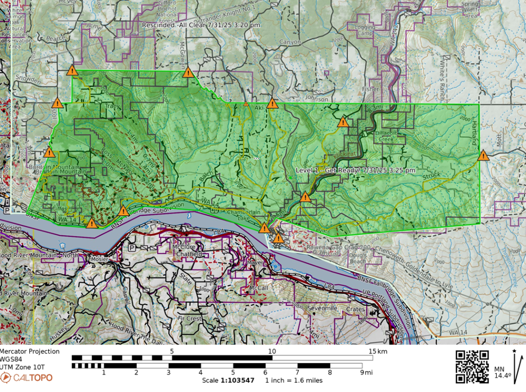
Burdoin Fire Evacuation update. The Klickitat County Sheriff’s Office has reduced all evacuation zones within the Burdoin Fire by one level. Level 2 is now a Level 1 and Level 1 is rescinded. All local roads within the fire area will continue to be for local access only.
For information on the most current evacuations and all road closures, check the interactive map at https://caltopo.com/m/0NL3FK3.
Contact and Information – Email – [email protected]
Emergency Operations Center (EOC) Phone – (509) 773-0570 (M-F 8am-5pm)
Facebook – https://www.facebook.com/KlickitatDEM911
To receive emergency notifications, please sign-up at https://www.smart911.com/smart911/ref/login.action?pa=klickitatco
7/31 9:00 a.m. update
7/30 9:00 a.m. update
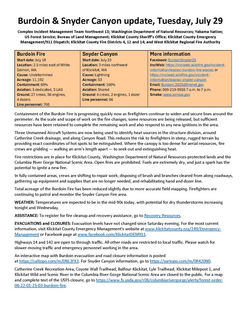
7/29 9:00 a.m. update
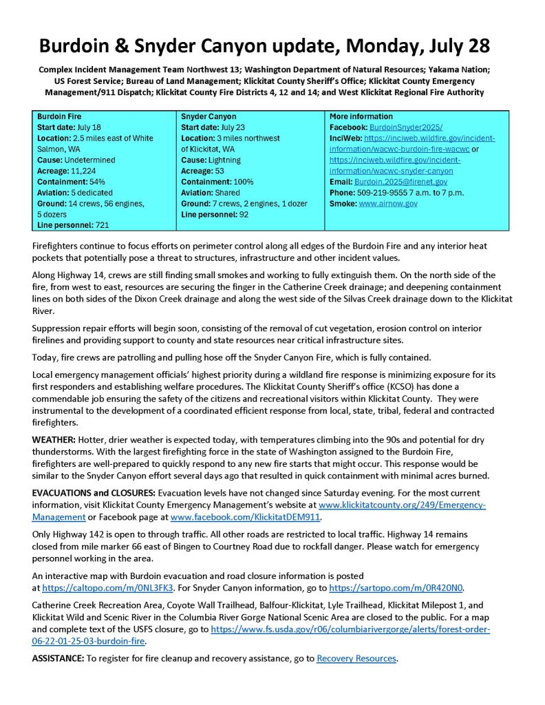
7/28 9:00 a.m. update

7/27 9:00 a.m. update
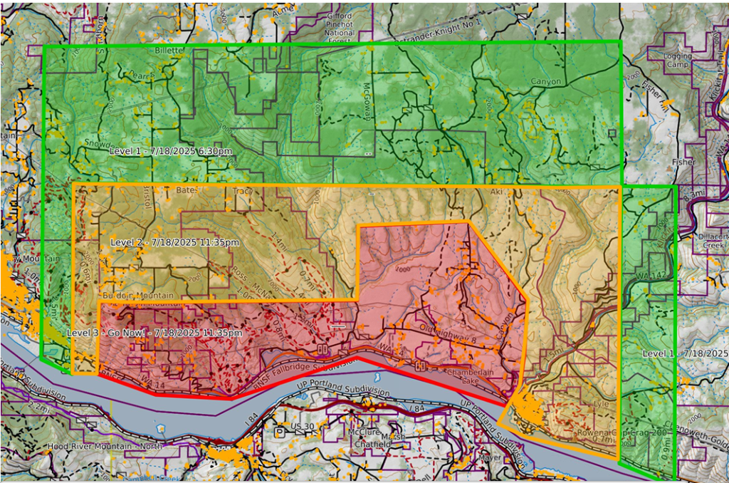
7/26 5:00 p.m. update
The Klickitat County Sheriff’s Office has updated the evacuation areas. All evacuation levels are being decreased.
• All Level 3 evacuation levels are being decreased to a Level 2 Be Set
• All prior Level 2 evacuation zones are being decreased to Level 1 Get Ready and the Eastern border of the evacuation zone has been adjusted on the east side o The eastern boarder now extends North from five-mile creek on Hwy 14 to the North East corner at the intersection of Red Tail Rd. and Schilling Rd.
• All prior Level 1 evacuation zones have been removed. All roads are being opened for local traffic only.
Parts of Hwy 14 are reopened, but the section of Hwy 14 between the East side of Bingen and Courtney Road will remain closed due to rock fall danger in the area of Mile Marker 69.
Check the interactive map for up-to-date information https://sartopo.com/m/0NL3FK3
Klickitat County Health Department has reentry kits available for those returning home.
7/26 9:00 a.m. update
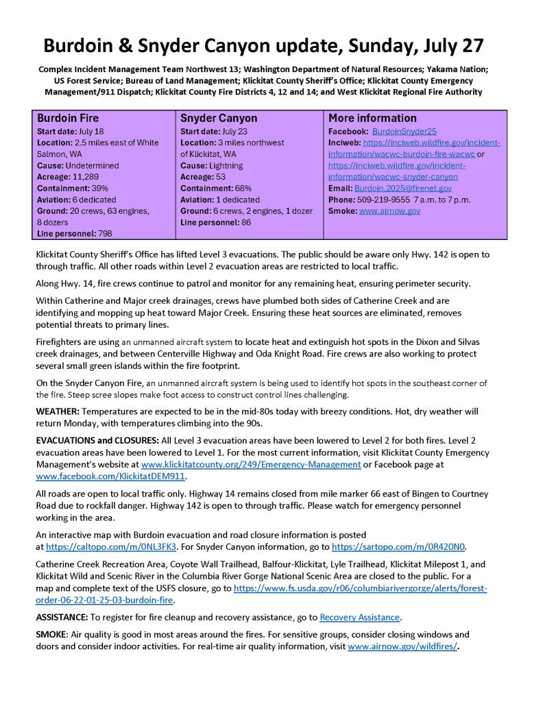
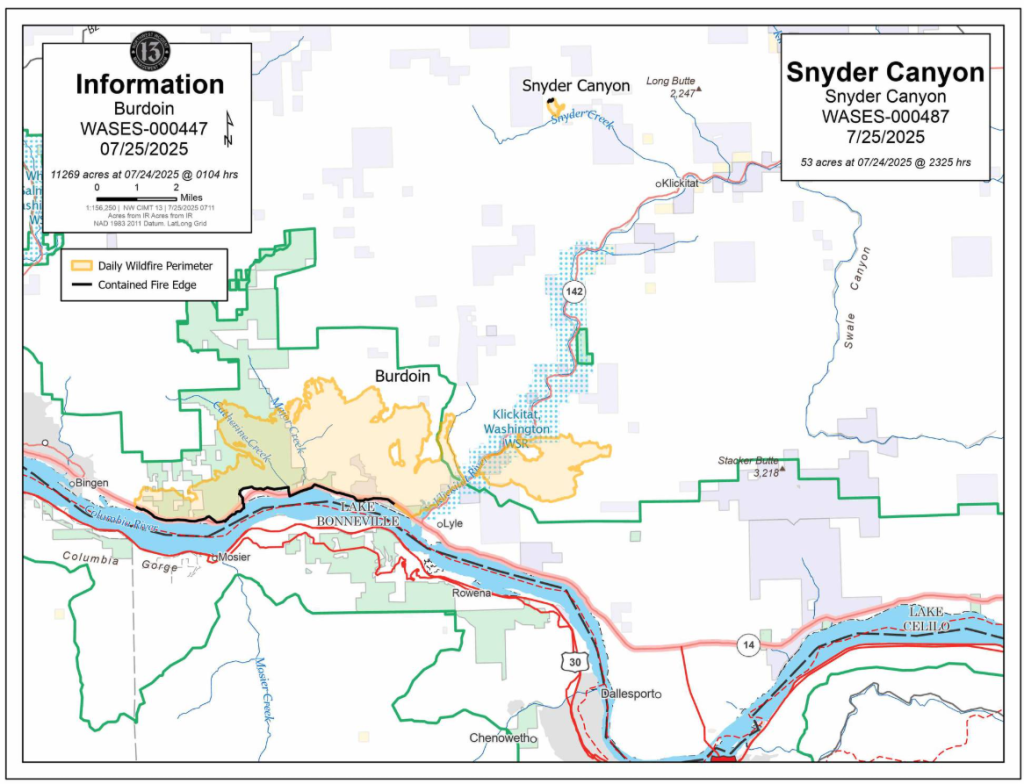
7/25 9:00 a.m. update
7/24 9:00 a.m. update
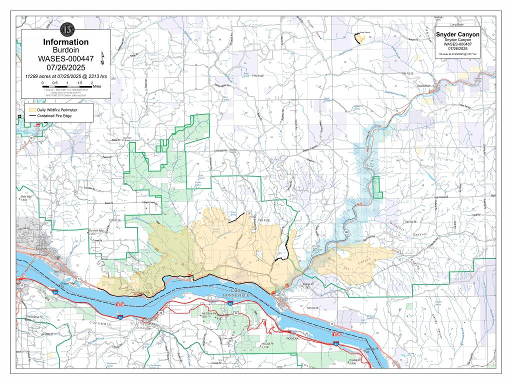
Fire size: 11,248 acres
Cause: Under investigation
Percent Contained: 13
Aviation: 5 dedicated
Full Suppression Fire
Ground: 86 engines, 7 dozers, 18 hand
Total personnel: 846
Tactical firing operations supported by aviation Wednesday closed the final gaps in lines around the Burdoin Fire perimeter, but it will take time to fully contain the fire.
Active burning, including isolated torching, is still taking place in many areas of the fire. Containment means the threat of a fire escaping its boundaries are significantly reduced. Due to the terrain and fuels in some areas of the fire, extensive work will be needed to achieve these conditions.
The structure protection group is continuously patrolling residential areas and extinguishing any signs of heat around homes.
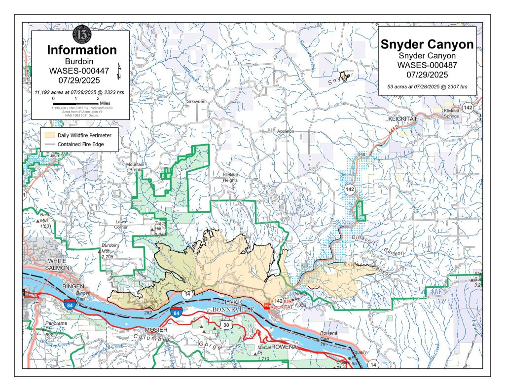
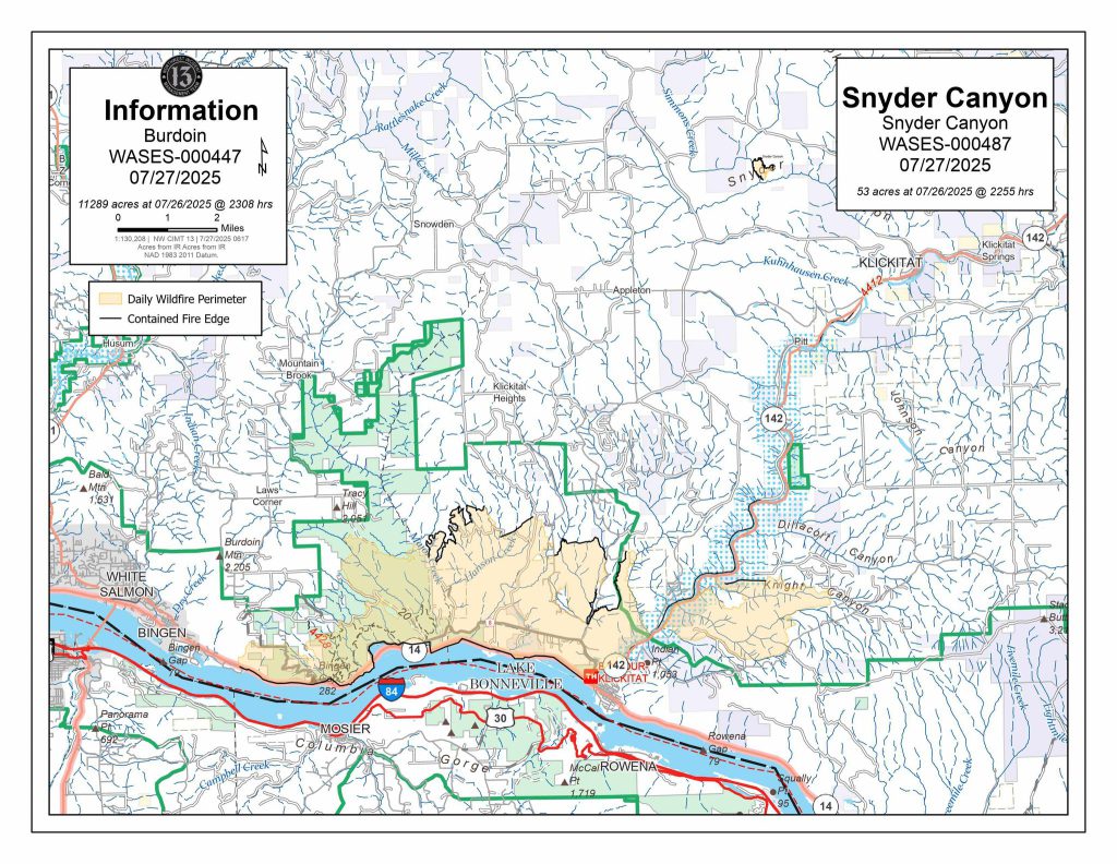
This morning, Complex Incident Management Team Northwest 13 also assumed command of the 52-acre Snyder Canyon Fire near Klickitat.
WEATHER: Today will be a critical day on the fire, with conditions very similar to the day the fire ignited. High temperatures, sustained winds of 20 miles per hour and gusts up to 35 mph are expected to test firelines and challenge firefighters today.
EVACUATIONS and CLOSURES: Evacuation levels have not changed for the Burdoin Fire. There are Level 3 – Go Now! and Level 2 – Get Set evacuation levels in and around the communities of Klickitat and Wahkiacus. An interactive map with evacuation and road closure information can be found at https://caltopo.com/m/0NL3FK3.
Highway 14 remains closed from mile marker 66 east of Bingen to mile marker 76 west of Lyle. Other closures include Highway 142 from Highway 14 north to mile marker 5, and Centerville Highway from Highway 14 to Schilling Road. Canyon Road is closed.
For the most current information, please visit Klickitat County Emergency Management’s website at www.klickitatcounty.org/249/Emergency-Management or Facebook page at www.facebook.com/KlickitatDEM911.
Catherine Creek Recreation Area, Coyote Wall Trailhead, Balfour-Klickitat, Lyle Trailhead, Klickitat Milepost 1, and Klickitat Wild and Scenic River in the Columbia River Gorge National Scenic Area are closed to the public. For a map and complete text of the USFS closure, go to https://www.fs.usda.gov/…/forest-order-06-22-01-25-03….
Red Cross Emergency Shelters are located at Grace Baptist Church, 1280 W. Jewett Blvd, in White Salmon, WA, and The Dalles Middle School, 1100 E. 12th St., The Dalles, OR. Red Cross staff can assist affected residents and property owners with identifying and accessing other resources. Anyone trying to locate a loved one should call 1-800-REDCROSS (733-2767)
SMOKE: Air quality is good in most areas around the fire. For sensitive groups, consider closing windows and doors and consider indoor activities. For real-time information on smoke and air quality, https://fire.airnow.gov/#9.35/45.5916/-121.3854.
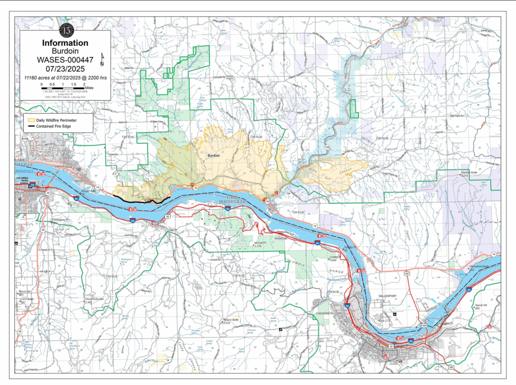
7/23 11:40 a.m. update
Klickitat PUD Burdoin Mountain Fire Power Restoration UPDATE 07/23/25
KPUD crews completed the majority of repairs to the damage in the Old Highway 8 area and have restored power to most services that were not damaged. One pole replacement remains; crews were unable to access it yesterday, but the KPUD dock crew is actively working on it and estimates completion by the end of today.
Today, KPUD and dock crews are completing repairs in the Courtney Road and Windy Bluff area. This work will restore power to all customers in the Burdoin Mountain area, except for those with damaged services. The estimated time of restoral is by end of day today.
The challenging access and terrain have made restoration efforts difficult. We appreciate your patience and understanding.
If you have any questions regarding your electric service or repairs that may be needed, please contact the Engineering Department at 800–548-8357.
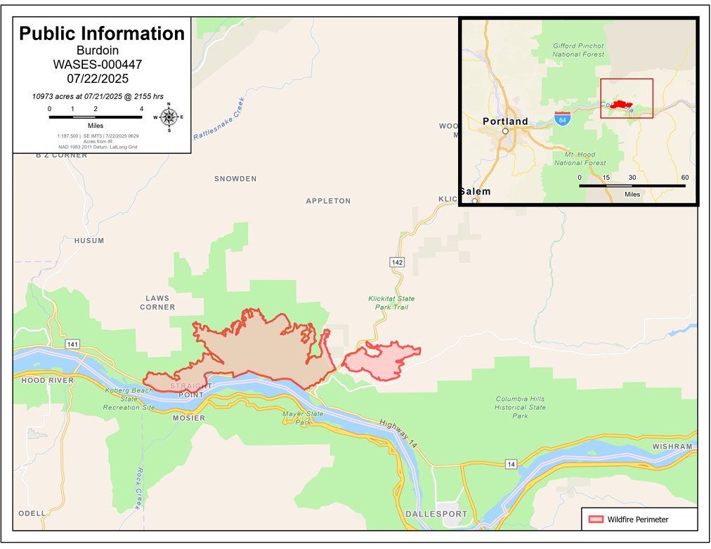
7/23 9:00 a.m. update
Fire start date: July 18
Location: 2.5 miles east of White Salmon, WA
Fire size: 10,993 acres
Cause: Under investigation
Percent Contained: 5
Aviation: 5 dedicated Full Suppression Fire
Ground: 105 engines, 3 dozers, 19 hand crews
Total personnel: 870
Fully extinguishing sources of heat around homes, structures and infrastructure is the highest priority for the Burdoin Fire suppression operation.
Throughout the fire area, the structure group is systematically assessing properties, finding and extinguishing flareups and any material still smoldering. Most properties have been hardened — meaning potential fuels have been removed — 50 to 100 feet, but fire officials want to expand these perimeters to 200 feet.
Until these areas are safe, Klickitat County Sheriff’s Office said evacuations will remain in place.
Ground crews have completed direct containment lines in many areas of the fire. Tuesday, crews used tactical ignitions to close unburned pockets of fuel and reinforce containment lines around the Catherine Creek drainage to the west and around the fire east of Klickitat River.
It will take some time to fully control fire in timbered areas of steep canyons. Burning forest litter can ignite larger deadfall fuels which burn very slowly, potentially smoldering for weeks or months.
WEATHER: Within the Columbia Gorge, increasing temperatures are accompanied by increased wind activity. Temperatures are expected to be above average today and Thursday, with sustained winds of 20 miles per hour and gusts up to 35 miles per hour.
CLOSURES: Highway 14 remains closed from mile marker 66 east of Bingen to mile marker 76 west of Lyle. Other closures include Highway 142 from Highway 14 north to mile marker 5, and Centerville Highway from Highway 14 to Schilling Road. County road closures are posted at https://caltopo.com/m/0NL3FK3. State highway closures can be found at https://wsdot.com/travel/real-time/. Travelers should find alternate routes.
Catherine Creek Recreation Area, Coyote Wall Trailhead, Balfour-Klickitat, Lyle Trailhead, Klickitat Milepost 1, and Klickitat Wild and Scenic River in the Columbia River Gorge National Scenic Area are closed to the public. For a map and complete text of the USFS closure, go to https://www.fs.usda.gov/r06/columbiarivergorge/alerts/forest-order-06-22-01-25-03-burdoin-fire.
EVACUATIONS: For the most current information, please visit Klickitat County Emergency Management’s website at www.klickitatcounty.org/249/Emergency-Management or Facebook page at www.facebook.com/KlickitatDEM911. An interactive map can be found at https://caltopo.com/m/0NL3FK3.
Red Cross Emergency Shelters are located at Grace Baptist Church, 1280 W. Jewett Blvd, in White Salmon, WA, and The Dalles Middle School, 1100 E. 12th St., The Dalles, OR. Red Cross staff can assist affected residents and property owners with identifying and accessing other resources.
SMOKE: Air quality is good in most areas around the fire. For sensitive groups, consider closing windows and doors and consider indoor activities. For more real-time air quality information, go to fire.airnow.gov/#9.35/45.5916/-121.3854.
7/22 9:00 a.m. update
Brian Gales, Incident Commander Eric Riener, Deputy Incident Commander
| Fire start date: July 18 | Location: 2.5 miles east of White Salmon, WA | Cause: Under investigation |
| Fire size: 10,993 acres | Percent Contained: 0 | Full Suppression Fire |
| Aviation: 5 dedicated | Ground: 105 engines, 3 dozers, 18 hand crews | Total personnel: 842 |
Nearly 850 personnel and fire resources are now engaged in suppressing the Burdoin Fire. This mixture of resources includes firefighters, wildland fire engines, structural engines, heavy equipment, aviation and support personnel.
At the west end of the fire, a dedicated structure group is assessing all damaged structures along Highway 14 and Old Highway 8. The structure group also ensures there is no potential for reburning and will provide additional protection for non-impacted residences.
Klickitat County Sheriff’s Office, Emergency Management and Assessors’ Office are working to visually confirm the number of structures damaged or destroyed. Individual property owners will be contacted directly by a county official.
Monday, fixed wing scoopers and heavy helicopters helped slow the fire’s movement while hand crews and dozers built lines from the west across Catherine Creek and east across Major Creek. This operational objective will connect the two lines on the ridges in between these drainages.
On the east side of the fire, ground crews completed hand and dozer lines around a large spot fire to the east of the Klickitat River and north of Centerville Highway. Work will continue to strengthen, secure, and monitor all firelines east of the river.
WEATHER: Showers and thunderstorms across the Cascades dropped minimal precipitation within the fire zone. Warmer, drier weather will return today and continue through Thursday, with wind potential up to 35 miles per hour later in the week.
Klickitat County Sheriff’s Office, Emergency Management and Assessors’ Office are working to visually confirm the number of structures damaged or destroyed. Individual property owners will be contacted directly by a county official.
SMOKE: Air quality is good in most areas around the fire. For sensitive groups, consider closing windows and doors and consider indoor activities. For more information on smoke and air quality, visit Washington Smoke Information at https://wasmoke.blogspot.com/
EVACUATIONS: Evacuation levels from Doug’s Beach east along Hwy. 14 to Horsethief Lake north have been reduced to a “Level 2 – Be Set” by the Klickitat County Sheriff’s Office. All other evacuation levels remain the same. For the most current information, please visit Klickitat County Emergency Management’s website at www.klickitatcounty.org/249/Emergency-Management or www.facebook.com/KlickitatDEM911. An interactive map can be found at https://caltopo.com/m/0NL3FK3.
Red Cross Emergency Shelters are located at Grace Baptist Church, 1280 W. Jewett Blvd, in White Salmon, WA, and The Dalles Middle School, 1100 E. 12th St., The Dalles, OR. Red Cross staff can assist affected residents and property owners with identifying and accessing other resources.
CLOSURES: Highway 14 remains closed from mile marker 66 east of Bingen to mile marker 76 west of Lyle. Other closures include Highway 142 from Highway 14 north to mile marker 5, and Centerville Highway from Highway 14 to Schilling Road. Additional closures are posted at https://wsdot.com/travel/real-time/. Travelers should find alternate routes.
Catherine Creek Recreation Area, Coyote Wall Trailhead, Balfour-Klickitat, Lyle Trailhead, Klickitat Milepost 1, and Klickitat Wild and Scenic River in the Columbia River Gorge National Scenic Area are closed to the public. For a map and complete text of the USFS closure,
go to https://www.fs.usda.gov/r06/columbiarivergorge/alerts/forest-order-06-22-01-25-03-burdoin-fire.
7/21 3:00 p.m. update
Northwest 13 Complex Incident Management Team has taken command of the suppression operation on the Burdoin Fire and is working very closely with Klickitat County Fire Districts 4, 14 and 12; West Klickitat Fire Authority; Klickitat County Sheriff’s Office, Klickitat County Emergency Management/911 Dispatch.
Evacuation levels from Doug’s Beach east along Hwy. 14 to Horsethief Lake north have been reduced to Level 2 – Be Set by the Klickitat County Sheriff’s Office. For specific information, check the interactive map at https://caltopo.com/m/0NL3FK3
Klickitat County Sheriff’s Office, Emergency Management and Assessors’ Office are working to visually confirm the number of structures damaged or destroyed. Individual property owners will be contacted directly by a county official.
No fatalities have been confirmed, and no individuals are known to be unaccounted for.
Hwy. 14, Old Hwy. 8, Hwy. 142 and Lyle-snowden Road will remain closed to the public until it is safe to reopen them. The top priority of all agencies and partners is the safety of the public and responders. Hazards within the fire footprint include rocks and other debris rolling downhill, falling trees, hot spots and downed power lines.
Today’s cooler, wetter weather has moderated fire behavior, but it is still burning actively, particularly in the timber understory where rainfall has not penetrated. Fire suppression work will continue until it is fully contained.
Red Cross shelters are located at Grace Baptist Church, 1280 W. Jewett Blvd, in White Salmon and at The Dalles Middle School, 1100 E. 12th St., The Dalles, Ore. In addition to temporary shelter, Red Cross staff can assist affected residents and property owners with identifying and accessing other resources.
####
CLOSURE: Columbia River Gorge National Scenic Area has issued a closure order for Catherine Creek Recreation Area, Coyote Wall Trailhead, Balfour-Klickitat, Lyle Trailhead, Klickitat Milepost 1, and Klickitat Wild and Scenic River. For a map and complete text of the closure, go to https://www.fs.usda.gov/…/forest-order-06-22-01-25-03…
FEMA Authorizes Funds to Fight Burdoin Fire in Washington
BOTHELL, Wash. – The Federal Emergency Management Agency (FEMA) authorized the use of federal funds to help with firefighting costs for the Burdoin Fire burning in Klickitat County, Washington, and on land of the Confederated Tribes and Bands of the Yakama Nation.
The state of Washington’s request for a declaration under FEMA’s Fire Management Assistance Grant (FMAG) program was approved by FEMA Region 10 Acting Administrator Vincent J. Maykovich on Saturday, July 19, 2025, at 5:15 p.m. PT. He determined that the Burdoin Fire threatened to cause such destruction as would constitute a major disaster. This is the first FMAG declaration in 2025 to help fight Washington wildfires.
At the time of the state’s request, the wildfire threatened homes in and around the communities of White Salmon, Bingen, Straight Point and Lyle. The fire also threatened roadways, railways and local powerlines. It was also impacting the Columbia River Scenic Area and turtle habitat in the area.
FMAGs make funding available to pay up to 75 percent of a state’s eligible firefighting costs for fires that threaten to become major disasters. Eligible items can include expenses for field camps, equipment use, materials, supplies and mobilization and demobilization activities attributed to fighting the fire. These grants do not provide assistance to individual home or business owners and do not cover other infrastructure damage caused by the fire.
###
7/21 8:30 a.m. update
Complex Incident Management Team Northwest 13 assumed command of the fire today at 6 a.m. We would like to thank initial attack and Southeast Washington Incident Management Team 2 for their hard work over the last several days.
The Burdoin Fire is being managed as a full suppression incident. Primary objectives are to minimize impacts to communities and community infrastructure in Bingen, Lyle, and High Prairie, Yakama Nation lands, and natural resources.
The fire is primarily moving to the north and northeast in steep terrain. Multiple scooper aircraft and helicopters are supporting resources on the ground with strategic water drops to cool the fire’s forward edge. Additional resources are en route and are being assigned as they arrive.
Significant aviation assets, including fixed wing scooper aircraft and Type 1 helicopters, are being utilized to minimize fire growth. These assets are using the Columbia River as their water source. River recreationists should be extra cautious between the Dalles Port and White Salmon.
A slop over on Lyle Snowden Road was halted Sunday. Overnight tactical ignition operations around a spot fire to the east were successful. Crews will continue working today to reinforce that work around Stupp Road. Crews will be working along the Catherine Creek drainage while an interagency hotshot crew scouts potential lines to tie into Major Creek.
On the northwest edge of the fire, a combination of hand and dozer line is holding, and ground crews are attacking the fire from this area as a secure point to engage the fire.
WEATHER: Cooler temperatures and higher humidity Sunday and today will help moderate fire behavior, however, it is still burning actively. Winds are expected to range from 7 to 21 miles per hour, with gusts up to 23 on the ridgetops.
SMOKE: Smoke may be visible to the northeast, where it is consuming fuels within the fire footprint along Catherine Creek. Air quality is good in most areas around the fire. For sensitive groups, consider closing windows and doors and consider indoor activities. For more information on smoke and air quality, visit Washington Smoke Information at https://wasmoke.blogspot.com/
EVACUATIONS: Evacuation levels have not changed and are coordinated through the Klickitat County Sheriff’s Office. Please visit Klickitat County Emergency Management’s website www.klickitatcounty.org/249/Emergency-Management or www.facebook.com/KlickitatDEM911 for the most current information. Red Cross Emergency Shelters are set up at Columbia High School, C Court Building, 1455 NW Bruin Country Road, White Salmon, WA, (access is from NW Simmons Road) and The Dalles Middle School, 1100 E. 12th St., The Dalles, OR, to assist with evacuation.
CLOSURES: Highway 14 remains closed from mile marker 66 east of Bingen to mile marker 76 west of Lyle. Other closures include Highway 142 from Highway 14 north to mile marker 5, and Centerville Highway from Highway 14 to Centerville. Travelers should find alternate routes.There is fire activity in and around the portions of the Columbia River Gorge National Scenic Area bordering the fire. For your safety and that of firefighters, please recreate in other areas.
7/20 9:30 p.m. update
Estimated Size: 8,776 acres (acreage adjustment is due to better mapping)
Containment: 0%
Start Date/Time: 7/18/2025 around 2:29 PM
Area of Fire: Klickitat County WA, Bingen/Lyle area
Cause: Undetermined Structures Damaged: Primary structures: 37 damaged, 14 destroyed; Minor structures: 50 damaged, 30 destroyed
Injuries: One firefighter transported
Evacuation Levels: Evacuation levels continue to change. Please visit Klickitat County Emergency Management’s website or check Facebook: https://www.klickitatcounty.org/249/Emergency-Management https://www.facebook.com/KlickitatDEM911
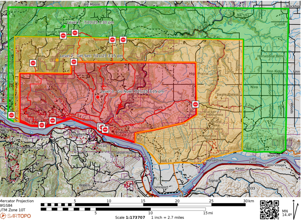
Level 3 “GO NOW” Go now! Danger in your area is current or imminent and you should evacuate immediately. Follow directions from law enforcement or fire departments and do not return home until officials have determined it is safe. Notification that it is safe to return home will be given as soon as possible.
Level 2 “GET SET” Be prepared for sudden or short-notice evacuation. People who need help or more time to evacuate — such as people with disabilities, people with small children, people with medical conditions, and people with large animals — should evacuate now. Ensure your evacuation plan checklist is complete and your Go! kit is in your vehicle. Stay informed and be aware of alerts from local law enforcement and fire departments. Always remember to leave if you feel unsafe, do not wait for an official evacuation order.
Level 1 “GET READY” Be aware of the danger in your area and start preparing for possible evacuation. Monitor local media and check on neighbors. If you do not already have an evacuation plan or a Go! kit, assemble these now. Conditions can change suddenly, and you may not receive a Level 2 “Be Set” warning before you are ordered to Level 3 “Go!” Prepare both the inside and outside of your home for fire. Leave if you feel unsafe — do not wait for an official evacuation order.
Columbia High School – C Court Building 1455 NW Bruin County Rd White Salmon, WA 98672 (Access is from NW Simmon Road. Follow the Red Cross signs to the back of the property.)
The Dalles Middle School 1100 E. 12th Street The Dalles, OR 97058
Update: The fire was active today. Crews continued with structure protection while others worked on securing fire lines around the perimeter of the fire. With the moderated weather conditions, ground forces were able to make progress on securing fire line on the west end of the fire. Interior crews continued to work to improve and mop-up around structures. Crews also worked throughout the day to improve and secure the spot fire north of Lyle. Additional resources were assigned to the Lyle-Snowden Road area to install and improve control lines.
Tomorrow morning Complex Incident Management Team – Northwest 13 will assume command of the Burdoin Fire. Their team arrived through the day on Sunday and coordinated with SE Washington IMT’s members. The larger team has more team members which will allow for broader span of control over the many different responders and equipment working and enroute to the Burdoin Fire.
Highway 14 remains closed from mile marker 66, east of Bingen to mile marker 76, west of Lyle. Other closures include Highway 142 from Highway 14 north to mile post 5, and Centerville Highway from Highway 14 to Centerville. Travelers should find alternate routes.
The closures in the fire area and evacuation levels are still in place. The Klickitat County Sheriff’s Office and Klickitat County Emergency Management are continuing discussions to develop a plan on when and how to coordinate allowing residents back into the burned area. For up-to-date information on closures and reopening follow Kittitas Emergency Management on their Facebook page or at their website: – – https://www.klickitatcounty.org/249/Emergency-Management https://www.facebook.com/KlickitatDEM911
Weather and Fire Behavior: Tonight we should see temps in the low 60s with west winds 1015 mph, gusts up to 25 mph becoming 5-10 mph, gusts up to 15 mph after 10 p.m.. Monday will have highs in the low 80s, west winds 3-7 mph becoming 6-12 mph with gusts up to 20 mph after 10 a.m.
Smoke: Air quality is good with haze and smoke possible. For sensitive groups, monitor for smoke, closing doors and windows as needed going indoors if you have symptoms. For more information on smoke and air quality, visit Washington Smoke Information (https://wasmoke.blogspot.com/).
Air Space Restrictions: There is a Temporary Flight Restriction (TFR) in place over the fire. Any unaccounted-for aircraft, including drones, puts aerial firefighting resources and lives at risk. If you fly, we can’t. All firefighting aircraft must be grounded if unmanned aircraft or drones are operating near the fire.
Resources: Nine strike teams. Five hand crews. Three dozers. 39 engines. Eight water tenders. Fire support is approximately 289 people.
###
7/20 7:00 p.m. update
Estimated Size: 8,776 acres (acreage adjustment is due to better mapping)
Containment: 0% Start Date/Time: 7/18/2025 around 2:29 PM
Area of Fire: Klickitat County WA, Bingen/Lyle area
Cause: Undetermined
Structures Damaged: Primary structures: 37 damaged, 14 destroyed; Minor structures: 50 damaged, 30 destroyed
Injuries: One firefighter transported
Evacuation Levels: Evacuation levels have changed. Please visit Klickitat County Emergency Management’s website or check Facebook: – https://www.klickitatcounty.org/249/Emergency-Management – https://www.facebook.com/KlickitatDEM911
Level 3 “GO NOW” Go now! Danger in your area is current or imminent and you should evacuate immediately. Follow directions from law enforcement or fire departments and do not return home until officials have determined it is safe. Notification that it is safe to return home will be given as soon as possible.
Level 2 “GET SET” Be prepared for sudden or short-notice evacuation. People who need help or more time to evacuate — such as people with disabilities, people with small children, people with medical conditions, and people with large animals — should evacuate now. Ensure your evacuation plan checklist is complete and your Go! kit is in your vehicle. Stay informed and be aware of alerts from local law enforcement and fire departments. Always remember to leave if you feel unsafe, do not wait for an official evacuation order.
Level 1 “GET READY” Be aware of the danger in your area and start preparing for possible evacuation. Monitor local media and check on neighbors. If you do not already have an evacuation plan or a Go! kit, assemble these now. Conditions can change suddenly, and you may not receive a Level 2 “Be Set” warning before you are ordered to Level 3 “Go!” Prepare both the inside and outside of your home for fire. Leave if you feel unsafe — do not wait for an official evacuation order.
Columbia High School – C Court Building 1455 NW Bruin County Rd White Salmon, WA 98672 (Access is from NW Simmon Road. Follow the Red Cross signs to the back of the property.)
The Dalles Middle School 1100 E. 12th Street The Dalles, OR 97058
Update: Steady wind and 25 mile per hour gusts are expected to push the fire north and northeast on Sunday. The fire is active up the Klickitat River drainage. Level 3 evacuations remain in place for Lyle and much of the surrounding area.
Approximately 250 structures are threatened by the fire and more crews are arriving to help with the primary objective of protecting life safety, structures, property, and critical infrastructure. It is labor intensive and requires a lot of resources. Because of the complexity of the Burdoin Fire, Complex Incident Management Team – Northwest 13 will arrive Sunday evening and assume management of the fire on Monday. The larger team has significantly more overhead to manage current and incoming resources assigned to the fire. This will also assist with span of control for resources and firefighters currently working on the fire.
Ground crews will continue to be supported by multiple aircraft, which are dipping water from the Columbia River. Recreationists in the area should be aware of fire activity and use of the waterway. Recreating in the fire area is prohibited. Please be aware of all evacuation areas and closures. Accessing closed areas can impede the work of firefighters.
Highway 14 remains closed from mile marker 66, east of Bingen to mile marker 76, west of Lyle. Other closures include Highway 142 from Highway 14 north to mile post 5, and Centerville Highway from Highway 14 to Centerville. Travelers should find alternate routes.
The closures in the fire area will remain closed. There are a lot of hazards, and some areas have a significant amount of heat with small jackpots of burning fuels. Firefighters are continuing to patrol the fire and work to extinguish flareups, identify hotspots, and evaluate fire lines. Klickitat County Sheriff’s Office and Klickitat County Emergency Management are working together to develop a plan on when and how to coordinate allowing residents back into the burned area. For up-to-date information on closures and reopening follow Kittitas Emergency Management on their Facebook page or at their website: – – https://www.klickitatcounty.org/249/Emergency-Management https://www.facebook.com/KlickitatDEM911
Weather and Fire Behavior: Overcast skies and a high of 79 are expected for Sunday. Steady west winds around 15 mph and gusts up to 25 mph will continue into the night. A slight chance of lightning is forecasted for Sunday night.
Smoke: Air quality is good in the morning with haze and smoke possible. Some areas have moderate to unhealthy air conditions. For sensitive groups, please consider closing all doors and windows and going indoors if you have symptoms. For more information on smoke and air quality, visit Washington Smoke Information (https://wasmoke.blogspot.com/).
Air Space Restrictions: There is a Temporary Flight Restriction (TFR) in place over the fire. Any unaccounted-for aircraft, including drones, puts aerial firefighting resources and lives at risk. If you fly, we can’t. All firefighting aircraft must be grounded if unmanned aircraft or drones are operating near the fire.
Resources: Nine strike teams. Five hand crews. Three dozers. 39 engines. Eight water tenders. Fire support is approximately 289 people.
###
The Burdoin Fire continues to actively burn, posing a significant threat. The Klickitat County Sheriff’s Office, Fire Districts and Departments, Department of Emergency Management/911 Dispatch, Emergency Operations Center, and additional county and city departments are closely coordinating emergency response efforts and are issuing urgent messages to protect public and responder safety.
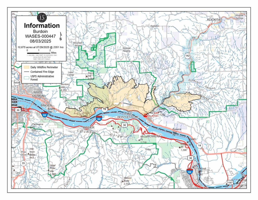
The fire is actively burning on both sides of the Klickitat River. On the West Side of the river the fire is continuing to burn Northwest towards Tracy Hill area (Major Creek and Bates Rd) and North in the Lyle Snowden Rd area South of McGowan Rd. On the East Side of the Klickitat River the fire is burning in the area of Oliver Point and heading East staying North of Centerville Highway. This Eastern finger of the fire spread to Struck Road Overnight. Residents can view the fire map and apply the fire activity layer located on the right side of the tool bar, to see the fire location.
Klickitat County Undersheriff Knopes: “The Level 3 Evacuation Zone remains closed to all residents at this time for the safety of first responders, prevention of potential looting, and the continued threat of additional wildfire spread. We have deputies in the area monitoring the ever changing fire behavior. Notification will be sent when you are allowed to return. If you need a residence checked, please call the Klickitat County Emergency Operations Center at 509-773-0570 and we will try to accommodate. The Klickitat County Sheriff’s Office will remain in the fire zones until the end of this event. Do not go around road closed signs, these are for your safety and everyone in the fire zones.”
The Burdoin Fire continues to actively burn, posing a significant threat. The Klickitat County Sheriff’s Office, Fire Districts and Departments, Department of Emergency Management/911 Dispatch, Emergency Operations Center, and additional county and city departments are closely coordinating emergency response efforts and are issuing urgent messages to protect public and responder safety.
The fire is actively burning on both sides of the Klickitat River. On the West Side of the river the fire is continuing to burn Northwest towards Tracy Hill area (Major Creek and Bates Rd) and North in the Lyle Snowden Rd area South of McGowan Rd. On the East Side of the Klickitat River the fire is burning in the area of Oliver Point and heading East staying North of Centerville Highway. This Eastern finger of the fire spread to Struck Road Overnight. Residents can view the fire map and apply the fire activity layer located on the right side of the tool bar, to see the fire location.
Klickitat County Undersheriff Knopes: “The Level 3 Evacuation Zone remains closed to all residents at this time for the safety of first responders, prevention of potential looting, and the continued threat of additional wildfire spread. We have deputies in the area monitoring the ever changing fire behavior. Notification will be sent when you are allowed to return. If you need a residence checked, please call the Klickitat County Emergency Operations Center at 509-773-0570 and we will try to accommodate. The Klickitat County Sheriff’s Office will remain in the fire zones until the end of this event. Do not go around road closed signs, these are for your safety and everyone in the fire zones.”
High Prairie Fire Chief Hancock: “If you are still in the High Prairie level 3 zone, you should evacuate immediately! Fire crews need clear access to protect homes and fight the fire. The entire High Prairie area is at risk.”
BoCC Chair Ron Ihrig: “I want to thank every one of our local volunteers, especially those assisting that have their own properties at risk, dispatchers, local law enforcement, and other departments that are assisting on this emergency.”
BoCC Lori Zoller: “We are in the midst of a terrible time for the people of this county. So many have invested time, money, and work to live in this beautiful area. Please remember stuff is replaceable. Be safe and help the firefighters and emergency personnel by following instructions. Let them do their job and keep them safe. We love and appreciate each of you and will be with you through and after this emergency.”
###
7/20 10:00 a.m. update
On the late afternoon of Saturday July 19th, 2025 the Burdoin Fire jumped the Klickitat River at Oliver Point and headed East, North of Centerville Highway. This finger of the fire spread to Struck Road overnight. Fire teams are working hard to contain the fire but everyone within the Level 3 Evacuation Zone needs to evacuate to ensure your safety and emergency responder safety. All evacuations that the Klickitat County Sheriff’s office issued at 4:15pm remain in effect until further notice (see fire map below).
High Prairie Fire Chief Hancock says “If you are still in High Prairie, you should evacuate immediately! Fire crews need clear access to protect homes and fight the fire. The entire High Prairie area is at risk.” Do not delay – ‘Level 3 Go Now’.
The live interactive evacuation map can be found here, the Klickitat County Emergency Management webpage (link), and the Klickitat County 911 Dispatch FaceBook page.
There are two Red Cross Emergency Shelters available. On the West Side the shelter is located at Columbia High School, C Court Building, off of NW Simmons Road in White Salmon. On the East Side the shelter is located at The Dalles Middle School in The Dalles, Oregon on East 12th Street.
For livestock and animal evacuation, shelter assistance, and general questions contact Klickitat County Emergency Operations Center at 509-773-0570. To receive emergency notifications, please Sign up.
7/19 6 p.m. update
Estimated Size: 6,506 acres
Containment: 0%
Start Date/Time: 7/18/2025 around 2:29 PM
Area of Fire: Klickitat County WA, Bingen/Lyle Area
Cause: Undetermined Structures Damaged: Primary structures: 37 damaged, 14 destroyed; Minor structures: 50 damaged, 30 destroyed
Evacuation Levels: Evacuation levels have changed. Please visit Klickitat County Emergency Management’s website or check Facebook: – https://www.klickitatcounty.org/249/Emergency-Management – https://www.facebook.com/KlickitatDEM911
Level 3 “GO NOW” Go now! Danger in your area is current or imminent and you should evacuate immediately. Follow directions from law enforcement or fire departments and do not return home until officials have determined it is safe. Notification that it is safe to return home will be given as soon as possible.
Level 2 “GET SET” Be prepared for sudden or short-notice evacuation. People who need help or more time to evacuate — such as people with disabilities, people with small children, people with medical conditions, and people with large animals — should evacuate now. Ensure your evacuation plan checklist is complete and your Go! kit is in your vehicle. Stay informed and be aware of alerts from local law enforcement and fire departments. Always remember to leave if you feel unsafe, do not wait for an official evacuation order.
Level 1 “GET READY” Be aware of the danger in your area and start preparing for possible evacuation. Monitor local media and check on neighbors. If you do not already have an evacuation plan or a Go! kit, assemble these now.
Conditions can change suddenly, and you may not receive a Level 2 “Be Set” warning before you are ordered to Level 3 “Go!” Prepare both the inside and outside of your home for fire. Leave if you feel unsafe — do not wait for an official evacuation order.
Shelter: Emergency Shelters are set up in White Salmon, Washington and in The Dalles, Oregon, to assist with evacuation.
Columbia High School – C Court Building 1455 NW Bruin County Rd White Salmon, WA 98672 (Access is from NW Simmons Road. Follow the Red Cross signs to the back of the property.)
The Dalles Middle School 1100 E. 12th Street The Dalles, OR 97058
Update: Wind continues to push the fire east where it crossed the Klickitat River and continued toward Lyle. The entire community of Lyle was placed on Level 3 evacuation Saturday afternoon.
Approximately 250 structures are threatened by the fire and crews are actively engaged in structure protection, spot fire management, and fire line construction. Progress was made on the west side of the fire, near Bingen as well as along Highway 14. Ground crews will work through the night, focusing specifically on the east front. Structural protection and active firefighting continue to be the priority. Efforts were assisted by multiple aircraft dipping from the Columbia River.
Highway 14 remains closed from mile marker 66, east of Bingen to mile marker 76, west of Lyle. Other closures include Highway 142 from Highway 14 north to mile post 5, and Centerville Highway from Highway 14 to Centerville. Travelers should find alternate routes.
Weather and Fire Behavior: Tonight the winds will continue. Tomorrow is expected to be mostly cloudy with continued wind, gusting up to 25 miles per hour in the afternoon.
Smoke: Air quality is good. For more information on smoke and air quality, visit Washington Smoke Information (https://wasmoke.blogspot.com/).
Air Space Restrictions: There is a Temporary Flight Restriction (TFR) in place over the fire. Any unaccounted-for aircraft, including drones, puts aerial firefighting resources and lives at risk. If you fly, we can’t. All firefighting aircraft must be grounded if unmanned aircraft or drones are operating near the fire.
Resources: Eight strike teams. Five hand crews. Three dozers. 39 engines. Eight water tenders. Fire support is approximately 289 people. Injuries: One firefighter transported for injury.
###
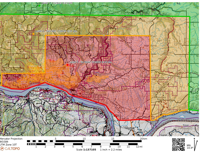
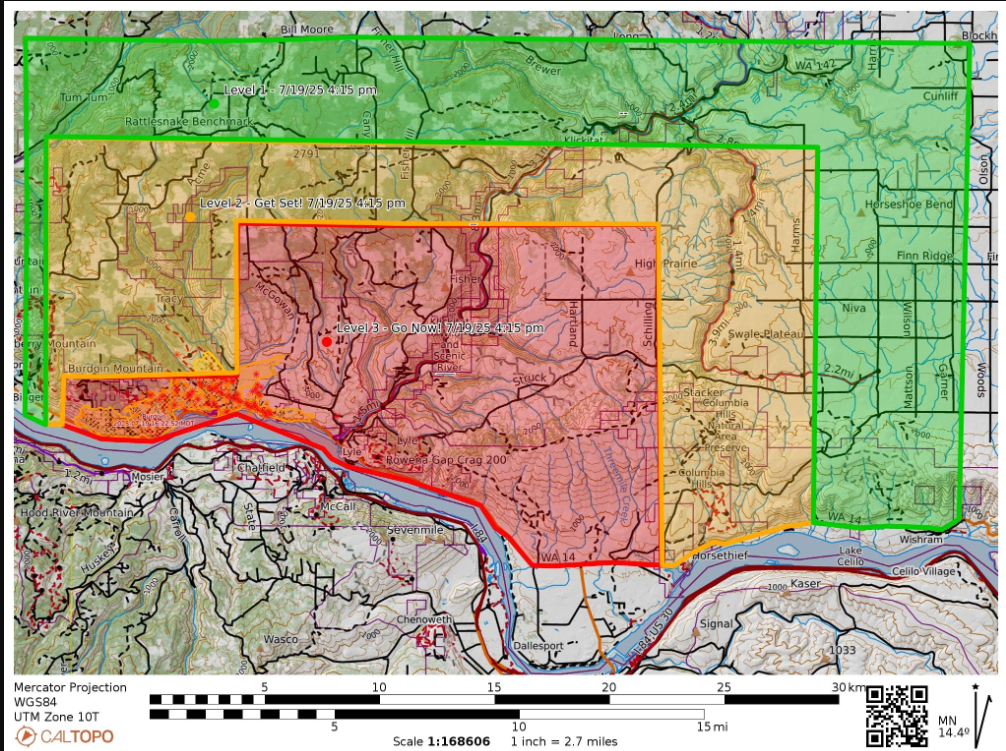
7/19 4:15 p.m. update
Expanded evacuation orders
7/19 2:00 p.m. update
The fire is continuing to progress North and East. The Klickitat County Sheriff’s office has expanded all evacuation zone levels to include areas further North and East.
The live interactive evacuation map can be found here, the Klickitat County Emergency Management webpage (link), and the Klickitat County 911 Dispatch FaceBook page.
There are two Red Cross Emergency Shelters available. On the West Side the shelter is located at Columbia High School, C Court Building, off of NW Simmons Road in White Salmon. On the East Side the shelter is located at The Dalles Middle School in The Dalles, Oregon on East 12th Street.
For livestock and animal evacuation and shelter assistance contact Klickitat County Emergency Operations Center.
The Southeast Washington InterAgency Incident Management Team (IMT) Type 3 took command at 6:30am.
Klickitat County Emergency Operations Center has been partially activated and can be reached at 509-773-0570 for information. To receive emergency notifications, please click here: Sign up
7/19 11:35 a.m. update
The fire is continuing to progress East and we have expanded the Level 3 evacuation zone to include the Town of Lyle.
The live interactive evacuation map can be found here , the Klickitat County Emergency Management webpage (link) , and the Klickitat County 911 Dispatch FaceBook page.
There are two Red Cross Emergency Shelters available. On the West Side the shelter is located at Columbia High School, C Court Building, off of NW Simmons Road in White Salmon. On the East Side the shelter is located at The Dalles Middle School in The Dalles, Oregon on East 12th Street.
For livestock and animal evacuation and shelter assistance contact Klickitat County Emergency Operations Center.
The State Type 3 Incident Management Team (IMT) took command at 6:30am. Klickitat County Emergency Operations Center has been partially activated and can be reached at 509-773-0570 for information.
To receive emergency notifications, please click here: Sign up
7/19 1:00 a.m. update
There is an active wildfire north of Highway 14 in Klickitat County. It began at approximately 2 pm near Courtney Road and Mile Post 68. Highway 14 is closed in both directions from the east end of Bingen to Lyle (Mile Marker 66-76).
Levels 1, 2, and 3 evacuations have been expanded as of 7/18/2025 at 11:30pm. The evacuation map as well as a hyperlink to the live interactive map can be found on the Klickitat County Emergency Management webpage (link) and Facebook page.
A Red Cross Emergency Shelter is located at Columbia High School, C Court Building, off of NW Simmons Road in White Salmon. For livestock and animal evacuation and shelter assistance contact Klickitat County Emergency Operations Center.
Klickitat County Emergency Operations Center has been partially activated and can be reached at 509-773-0570 for information.
To receive emergency notifications, please click here: Sign up
Klickitat PUD Responds to Burdoin Fire Damage in the Courtney Road Area Bingen, WA, July 18, 2025 – Klickitat PUD (KPUD) is actively responding to damage caused by the Burdoin Fire, which began Friday afternoon along Highway 14 in Bingen and spread through the Courtney Road area.
As the fire advanced, it damaged utility poles and power lines, initially leaving 52 customers without power. Additional damage occurred as the fire moved into more remote, difficult-to-access terrain.
KPUD crews have restored power to nine affected customers by rerouting service through an alternate feed from Snowden. Meanwhile, staff and line crews are continuing to assess the full extent of the damage. Due to the rugged landscape and limited access, assessments and repairs are expected to take place over the coming days. An update on overall structural loss will be provided as damage assessments continue.
To support restoration efforts, KPUD has mobilized a contractor crew from DJ’s Electrical and is utilizing specialized equipment to access and repair damaged infrastructure in challenging areas.
To ensure the safety of our crews, we will be suspending field work overnight and will resume repair efforts at daybreak on Saturday, July 19.
KPUD reminds all community members to stay far away from any downed power lines. Always assume lines are live and extremely dangerous. Never attempt to touch or move a downed line. Report it immediately to KPUD or call 911. Crews are making every effort to ensure the area is safe, but hazards may still exist in fire-affected areas.
Klickitat PUD thanks the community for their patience and understanding as we work to safely restore power. Our top priorities remain the safety of the public and our crews, and we remain committed to restoring power as quickly and safely as possible.
The Klickitat County Department of Emergency Management has established an emergency evacuation shelter at Columbia High School, located at 1455 NW Bruin Country Rd, White Salmon, WA 98672. Residents affected by the fire are encouraged to seek shelter and support at this location as needed.
State Fire Mobilization Authorized for the Burdoin Fire
Klickitat County – State fire assistance has been mobilized under the Washington State Fire Services Resource Mobilization Plan in support of local firefighters working to contain the Burdoin Fire located in Klickitat County, near the city of White Salmon. Washington State Patrol Chief John Batiste authorized the mobilization of state firefighting resources on July 18, 2025, at 5:15 p.m. at the request of Fire Chief Wes Long, West Klickitat Regional Fire Authority.
The Burdoin Fire started on July 18, 2025, at approximately 2:29 p.m. This fire is estimated at 2,000 acres and growing. It is burning in timber, brush, and grass and is threatening homes, crops, utilities, and cultural sites. Level 1, 2, and 3 evacuations are in effect at this time. The fire cause is currently under investigation.
The State Emergency Operations Center at Camp Murray is activated to Level 2, partial activation, to help coordinate state assistance for the Burdoin Fire. Mobilization specialists from the Fire Protection Bureau have ordered seven strike teams to aid in containment efforts. State Fire Marshal’s Office personnel are both en route to the scene and working remotely to coordinate the dispatch of resources.
Under the State Fire Services Resource Mobilization Plan, the Fire Protection Bureau coordinates the initial dispatch and continued administrative oversight of resources and personnel for the duration of the mobilization. The Mobilization Plan is implemented to provide a process to quickly notify, assemble and deploy fire service personnel, equipment and other resources from around the state when fires, disasters or other events exceed the capacity of local jurisdictions. More information about the Washington State Fire Services Resource Mobilization Plan is available at http://www.wsp.wa.gov/all-risk-mobilization/.
###