
9/05 9:33 am
Personnel: 333
Grasshopper Fire Acres: 93,993
Grasshopper Fire Percent Containment: 91%
Current Situation:
Crews were able to work on the Grasshopper Fire yesterday despite scattered showers throughout the day. The western side of the fire has received about 0.75 inches of rain in the last 72 hours. The diminished fire behavior gave firefighters a chance to extinguish remaining heat in a segment of the northwestern fire perimeter.
Crews working in the Boulder Creek drainage on Grasshopper’s southwest corner widened and secured fire line in the area where tethered logging equipment created breaks. The patience and hard work that have been focused on these critical areas has paid off and fire managers increased containment percentage to 91.
Today, firefighters are prepared to take advantage of similar conditions, working steadily towards full containment, and keeping a close eye on the risks that accompany significant moisture – falling rocks, slippery roads, and hazard trees.
Weather and Fire Behavior:
There is a slight chance of thunderstorms today, light rain, building to up to 0.25 of an inch of rain and breezy by Sunday. Warmer and dryer weather predicted for Thursday and Friday shows a return to temperatures in the 70s.
Smoke:
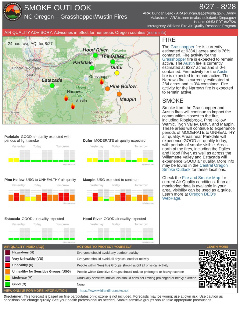
Air quality is looking good for most communities around the Grasshopper Fire today. Find timely, local air quality information at https://outlooks.airfire.org/outlook/50aab846
Evacuations and Closures:
Hood River and Wasco Counties have evacuation notices varying from Level 1 (Be Ready), Level 2 (Be Set), and Level 3 (Go Status). Check evacuations for Wasco and Hood River Counties at: https://perimetermap.com/
A forest closure is in place on Mt. Hood National Forest. The closure order and map are at: https://www.fs.usda.gov/r06/mthood/alerts/closure-place-grasshopper-fire
Fire Restrictions:
There are fire restrictions in place on Mt. Hood National Forest: https://www.fs.usda.gov/r06/mthood/alerts/fire-restrictions-effect-july-1. There are also burning and fire restrictions across the area. Check your local restrictions: https://www.oregon.gov/odf/fire/pages/restrictions.aspx
9/04 8:55 am
Personnel: 337
Grasshopper Fire Acres: 93,993
Grasshopper Fire Percent Containment: 84%
Current Situation:
The Mt. Hood National Forest announced a reduction in the Grasshopper Fire closure order yesterday, with increased fire containment and milder fire behavior factoring into the decision. Popular areas including Timberline Trail, Tamanawas Trail, and Rock Creek Campground and Day Use area are now accessible to the public.
Labor Day travellers should drive with caution near the Mt. Hood Meadows Ski Area which continues to serve as the Grasshopper Fire’s main camp. Yesterday’s lighter precipitation meant firefighters were able to get on the ground, fortifying containment features in the Boulder Creek drainage. Fire managers’ aim is to make the southwest corner of Grasshopper completely secure when the fire eventually backs down the mountain. Crews also worked near the northwest fire line on hot spots that persisted despite cold and wet conditions. Chipping, slash pile removal, suppression repair, and mop up took place throughout the fire area.
Weather and Fire Behavior:
Friday-Saturday we expect high temperatures in the 50s, up to 0.10” of rain, and winds of 15 mph. The return to more normal climate conditions makes the return of active fire behavior less likely.
Smoke:
Air quality is looking good for most communities around the Grasshopper Fire today. Find timely, local air quality information at https://outlooks.airfire.org/outlook/50aab846
Evacuations and Closures:
Hood River and Wasco Counties have evacuation notices varying from Level 1 (Be Ready), Level 2 (Be Set), and Level 3 (Go Status). Check evacuations for Wasco and Hood River Counties at: https://perimetermap.com/
A forest closure is in place on Mt. Hood National Forest. The closure order and map are at: https://www.fs.usda.gov/r06/mthood/alerts/closure-place-grasshopper-fire
Fire Restrictions:
There are fire restrictions in place on Mt. Hood National Forest: https://www.fs.usda.gov/r06/mthood/alerts/fire-restrictions-effect-july-1. There are also burning and fire restrictions across the area. Check your local restrictions: https://www.oregon.gov/odf/fire/pages/restrictions.aspx
9/03 9:50 am
Personnel: 393
Grasshopper Fire Acres: 93,993
Grasshopper Fire Percent Containment: 84%
Current Situation:
The rain predicted by Incident Meteorologist Sophia Adams arrived at the Grasshopper Fire yesterday, bringing around 0.25 inches to the east side of the fire, and more than 0.5 inches over the west side. As expected, fire activity was calm yesterday, allowing crews to make containment progress.
During this rainy period, firefighter safety will be emphasized due to the possibility of hazard trees, slick roads, and falling rocks. Crews will continue repair work today with heavy equipment and chipping along roads while conditions are safe to do so.
Weather and Fire Behavior:
Sporadic rain and a chance of thunderstorms are predicted today, accumulating in about 0.25 inches of precipitation. Winds will be lighter. Similar weather is expected tomorrow before warming and drying this weekend.
Smoke:
Air quality is looking good for most communities around the Grasshopper Fire today. Pine Hollow will have good air quality in the evening.
Find timely, local air quality information at https://outlooks.airfire.org/outlook/50aab846
Evacuations and Closures:
Hood River and Wasco Counties have evacuation notices varying from Level 1 (Be Ready), Level 2 (Be Set), and Level 3 (Go Status). Check evacuations for Wasco and Hood River Counties at: https://perimetermap.com/
A forest closure is in place on Mt. Hood National Forest: https://www.fs.usda.gov/r06/mthood/alerts/closure-place-grasshopper-fire
Fire Restrictions:
There are fire restrictions in place on Mt. Hood National Forest: https://www.fs.usda.gov/r06/mthood/alerts/fire-restrictions-effect-july-1. There are also burning and fire restrictions across the area. Check your local restrictions: https://www.oregon.gov/odf/fire/pages/restrictions.aspx
9/02 8:37 am
Personnel: 389
Grasshopper Fire Acres: 93,972
Grasshopper Fire Percent Containment: 83%
Current Situation:
The forecasted cold front started swirling around Mount Hood last night, bringing gusty winds, much cooler temperatures, and rain to the Grasshopper Fire. The next three days will be a marked contrast to Monday and Tuesday’s fire activity, which kept crews busy holding fire within containment lines and features in the northwest and southwest corners of the fire perimeter.
Fire personnel will carefully assess conditions today. If the predicted 0.75 inches of rain materializes, transportation routes crews and heavy equipment operators have been using may not allow safe travel. Another serious concern is hazard trees. Trees that have been burned will have their root structures further tested by moisture and gusty winds.
Grasshopper Fire Deputy Incident Commander Clay Stephens said the strategies firefighters have been employing over the past weeks have succeeded in keeping fire growth to a minimum, despite challenging terrain. He said the rain will definitely help with some of the stubborn pockets of heat but cautions that a few days of precipitation won’t be enough to put the fire out. “But it certainly points us in the right direction,” he said.
Weather and Fire Behavior:
Today will be much cooler gusts up to 40 mph at ridgetops, rainfall accumulations up to 1 inch, and overcast skies, limiting fire behavior. Saturday and Sunday will start to trend warmer.
Smoke:
Today’s precipitation and breezy conditions is expected to improve the air quality in all the communities impacted by the Grasshopper Fire.
Find timely, local air quality information at https://outlooks.airfire.org/outlook/50aab846
Evacuations and Closures:
Hood River and Wasco Counties have evacuation notices varying from Level 1 (Be Ready), Level 2 (Be Set), and Level 3 (Go Status). Check evacuations for Wasco and Hood River Counties at: https://perimetermap.com/
A forest closure is in place on Mt. Hood National Forest: https://www.fs.usda.gov/r06/mthood/alerts/closure-place-grasshopper-fire
Fire Restrictions:
There are fire restrictions in place on Mt. Hood National Forest: https://www.fs.usda.gov/r06/mthood/alerts/fire-restrictions-effect-july-1. There are also burning and fire restrictions across the area. Check your local restrictions: https://www.oregon.gov/odf/fire/pages/restrictions.aspx
9/01 8:41 am
Personnel: 511
Grasshopper Fire Acres: 93,972
Grasshopper Fire Percent Containment: 83%
Current Situation:
Despite slightly warmer and drier weather over the Grasshopper Fire yesterday, fire activity was relatively quiet. Firefighters patrolled containment lines in the north and east regions of the fire to ensure no spots breached containment. Meanwhile, crews utilized excavators, chippers, dump trucks, and other logging equipment to repair past firefighting efforts throughout the fire.
The expertise and home turf advantage of the Zigzag Hotshots has been an asset for securing containment lines in the southwest corner of the fire. This work will continue today as firefighters focus on building a contingency line outside of the wilderness area where terrain is easier and safer to work in.
The Wasco County Sheriff’s Office has downgraded all Level 2 and Level 1 evacuation notices for Wasco County. Level 3 are still the same and have not been updated. See the updated map here: https://perimetermap.com/
Weather and Fire Behavior:
Today, expect westerly winds, cooler temperatures, and a chance of thunderstorms over the Grasshopper Fire. Up to an inch of rain is predicted to fall over the fire tomorrow.
Smoke:
Communities north of the Grasshopper Fire should have good air quality today. Maupin will experience some smoke in the morning, and Pine Hollow will likely experience unhealthy air quality for most of the day.
Find timely, local air quality information at https://outlooks.airfire.org/outlook/50aab846
Evacuations and Closures:
Hood River and Wasco Counties have evacuation notices varying from Level 1 (Be Ready), Level 2 (Be Set), and Level 3 (Go Status). Check evacuations for Wasco and Hood River Counties at: https://perimetermap.com/
A forest closure is in place on Mt. Hood National Forest: https://www.fs.usda.gov/r06/mthood/alerts/closure-place-grasshopper-fire
Fire Restrictions:
There are fire restrictions in place on Mt. Hood National Forest: https://www.fs.usda.gov/r06/mthood/alerts/fire-restrictions-effect-july-1. There are also burning and fire restrictions across the area.
Check your local restrictions: https://www.oregon.gov/odf/fire/pages/restrictions.aspx
8/31 10:03 am
Personnel: 622
Grasshopper Fire Acres: 93,961
Grasshopper Fire Percent Containment: 83%
Current Situation:
Over the past several weeks, tethered logging, roadside debris removal, and other operations required a lot of heavy machinery and personnel. The completion of these missions has made it possible to release some of these resources from the Grasshopper Fire, reflected in the significant reduction of firefighting and support personnel as compared to two weeks ago.
Tomorrow, firefighters are ready for another sunny, dry day, and light eastern winds. Crews have prepared sprinkler systems in the Boulder Creek area to keep fire within designated containment features, which are east of Boulder Lake. Work to maintain and increase containment in the northwest part of the fire will continue.
Most of the schools in the communities impacted by the Grasshopper Fire are celebrating the first day of school today. Fire and support personnel will be driving with extra caution, and request that other motorists also pay attention to the change in traffic levels.
Weather and Fire Behavior:
Today’s temperatures will bump by about 5 degrees. Additionally, a thermal belt at 4500-6000 feet in elevation, will contribute to elevated fire behavior. As a low-pressure system moves in, Tuesday starts the transition to a cooler, wetter pattern with a chance of thunderstorms.
Smoke:
Maupin and communities north of the Grasshopper Fire should have good air quality today. Pine Hollow will have good air quality in the afternoon and evening. Find timely, local air quality information at https://outlooks.airfire.org/outlook/50aab846
Evacuations and Closures:
Hood River and Wasco Counties have evacuation notices varying from Level 1 (Be Ready), Level 2 (Be Set), and Level 3 (Go Status). Check evacuations for Wasco and Hood River Counties at: https://perimetermap.com/
A forest closure is in place on Mt. Hood National Forest: https://www.fs.usda.gov/r06/mthood/alerts/closure-place-grasshopper-fire
Fire Restrictions:
There are fire restrictions in place on Mt. Hood National Forest: https://www.fs.usda.gov/r06/mthood/alerts/fire-restrictions-effect-july-1. There are also burning and fire restrictions across the area. Check your local restrictions: https://www.oregon.gov/odf/fire/pages/restrictions.aspx
8/30 10:18
Personnel: 705
Grasshopper Fire Acres: 93,953
Grasshopper Fire Percent Containment: 83%
Current Situation:
Fire activity was largely quiet across most of the Grasshopper Fire yesterday, thanks to cooler and wetter weather. In the southwest corner, the fire followed its expected behavior by backing and creeping towards containment lines. Containment was added in the northwest corner as crews increased confidence in their lines.
Firefighters will continue to focus efforts on Boulder Creek drainage in the southwest corner today. Today’s warmer weather and predicted increase in winds have potential to increase fire activity in this part of the fire.
Weather and Fire Behavior:
Warm and dry weather with light southeast winds is expected today over much of the Grasshopper Fire. Much of the same is predicted for tomorrow. As a low-pressure system moves in, Tuesday may bring unstable air and a chance of thunderstorms before rain starts on Wednesday.
Smoke:
Maupin and communities north of the Grasshopper Fire should have good air quality today. Pine Hollow will likely experience moderate air conditions for most of the day.
Find timely, local air quality information at https://outlooks.airfire.org/outlook/50aab846
Evacuations and Closures:
Hood River and Wasco Counties have evacuation notices varying from Level 1 (Be Ready), Level 2 (Be Set), and Level 3 (Go Status).
Check evacuations for Wasco and Hood River Counties at: https://perimetermap.com/
A forest closure is in place on Mt. Hood National Forest: https://www.fs.usda.gov/r06/mthood/alerts/closure-place-grasshopper-fire
Fire Restrictions:
There are fire restrictions in place on Mt. Hood National Forest: https://www.fs.usda.gov/r06/mthood/alerts/fire-restrictions-effect-july-1. There are also burning and fire restrictions across the area. Check your local restrictions: https://www.oregon.gov/odf/fire/pages/restrictions.aspx
8/28 11:05 am
Personnel: 809
Grasshopper Fire Acres: 93,886
Grasshopper Fire Percent Containment: 76%
Current Situation:
Yesterday, the southwest corner of the Grasshopper Fire cooperated with the containment strategy designed by fire operations specialists. This part of the fire slowly backed down the slope in the Boulder Creek drainage toward containment line hand crews have been constructing for several days. This area will continue to be a focus for minimizing the Grasshopper Fire’s growth.
The northwest and north sections of the fire were fairly quiet, with most of the fire activity consisting of interior pockets of unburned fuel. Elsewhere, crews and heavy equipment made progress on the significant task of repairing critical areas of fire line on the Grasshopper Fire’s east side.
Most resources assigned to the Tygh Valley camp transferred to Mt. Hood Meadows Thursday to position personnel nearer to the most active areas of the fire and to streamline fire camp logistics.
Weather and Fire Behavior:
The weather will yo-yo for the next few days, cooling Saturday and warming back up Sunday, but incident meteorologists are now forecasting the chance of up to 0.25 inches of rain by Wednesday.
Smoke:
Air quality for most communities in the Grasshopper Fire area has improved. Pine Hollow may experience some periods of lower air quality in the morning and early afternoon. Find timely, local air quality information at https://outlooks.airfire.org/outlook/50aab846
Evacuations and Closures:
Hood River and Wasco Counties have evacuation notices varying from Level 1 (Be Ready), Level 2 (Be Set), and Level 3 (Go Status).
Check evacuations for Wasco and Hood River Counties at: https://perimetermap.com/
A forest closure is in place on Mt. Hood National Forest: https://www.fs.usda.gov/r06/mthood/alerts/clackamas-river-rd-fires.
Fire Restrictions:
There are fire restrictions in place on Mt. Hood National Forest: https://www.fs.usda.gov/r06/mthood/alerts/fire-restrictions-effect-july-1. There are also burning and fire restrictions across the area. Check your local restrictions: https://www.oregon.gov/odf/fire/pages/restrictions.aspx
8/27 10:30 am
Acreage: 93,841 — Percent Containment: 76%
Winds up to 25 mph created more aggressive fire behavior on parts of the Grasshopper Fire on Wednesday, but firefighters responded in kind, using water, hand crews, logging and other heavy equipment to keep the fire from moving. To the north, crews strengthened contingency line and added pumps and fire hose to ensure protection of the Fivemile Butte Lookout.
The Grasshopper Fire camp in Tygh Valley is moving to Mt. Hood Meadows to bring fire personnel nearer to the most active areas of the fire. This means that today, and possibly through the weekend, there will be an increase in traffic, including large trucks, trailers and heavy equipment. Most vehicles will travel the southern route using Highways 216 and 26. Please use extra caution in these areas.
For the complete update and more information about the Grasshopper Fire, go to: https://inciweb.wildfire.gov/incid…/ormhf-grasshopper-fire
Mt. Hood National Forest- US Forest Service
Hood River County Sheriff’s Office
8/26 10:04 am
Personnel: 905
Grasshopper Fire Acres: 93,806
Grasshopper Fire Percent Containment: 76%
Current Situation:
Wasco County Sheriff Lane Magill eased evacuation levels in some areas that have been impacted by the Grasshopper Fire for weeks. The move is a result of confidence in the containment of the fire’s eastern perimeter after extensive suppression work proved successful.
The incident management team’s fire behavior analyst, Chris Belliston, called most of Tuesday’s fire activity “docile,” thanks in part to shading from the Austin Fire’s drifting smoke layer. A large helicopter dropped water on the fire for six hours, as firefighters took advantage of the overcast conditions to slow the fire’s spread.
Heavy equipment operators worked to remove wood debris along Highway 35 with Oregon Department of Transportation providing traffic control.
Weather and Fire Behavior:
Wednesday’s forecast includes continued low humidity and winds gusting up to 35 mph in the late evening. Thursday brings a low-pressure system with slightly cooler temperatures and westerly winds. By Saturday, there is a slight chance of rain.
Smoke:
Communities to the east of the Grasshopper Fire are expected to experience poor air quality, especially in the morning and late evening. To the north, air quality will improve for Hood River and The Dalles. Find timely, local air quality information at https://outlooks.airfire.org/outlook/50aab846
Evacuations and Closures:
Hood River and Wasco Counties have evacuation notices varying from Level 1 (Be Ready), Level 2 (Be Set), and Level 3 (Go Status). Yesterday, Wasco County Sheriff lifted Evacuations for the Following Zones: WRR, SPA, SH, SVR, HH, RH, SCH, JH, BD1, BD, TV, PHW, SP
Check evacuations for Wasco and Hood River Counties at: https://perimetermap.com/.
A forest closure is in place on Mt. Hood National Forest: https://www.fs.usda.gov/r06/mthood/alerts/clackamas-river-rd-fires.
Fire Restrictions:
There are fire restrictions in place on Mt. Hood National Forest: https://www.fs.usda.gov/r06/mthood/alerts/fire-restrictions-effect-july-1. There are also burning and fire restrictions across the area. Check your local restrictions: https://www.oregon.gov/odf/fire/pages/restrictions.aspx
8/25 10:13 am
Personnel: 1,013
Grasshopper Fire Acres: 93,794
Grasshopper Fire Percent Containment: 76%
Current Situation:
Personnel on the Grasshopper Fire are preparing for another challenging day on the fireline today, with rising temperatures, declining humidity and gusty winds forecasted. Yesterday, similar conditions energized Grasshopper’s two most active zones – the Boulder Creek area in the southwest corner and the northwest corner east of Highway 35. Aviation resources aided firefighters on the ground to minimize fire growth.
Tethered logging operations are continuing to work to remove thick fuels in steep terrain, while other logging operators are removing wood and slash piles near Highway 35.
Where containment line has held on the eastern and southern parts of the fire, plans are being made to rehabilitate the dozer and hand lines to avoid erosion and other resource damage.
Weather and Fire Behavior:
Fire managers and personnel are watching today for critically dry fuels — like pine needles, live trees, dead trees, shrubs and grass – to become more volatile. Tree torching is possible, and more smoke may be visible than in previous days.
Smoke:
Communities on the east side of the Grasshopper Fire will experience deteriorating air quality today, in some cases reaching the Unhealthy level. Find up to date, local air quality information at https://outlooks.airfire.org/outlook/50aab846
Evacuations and Closures:
Hood River and Wasco Counties have evacuation notices varying from Level 1 (Be Ready), Level 2 (Be Set), and Level 3 (Go Status). Check evacuations for Wasco and Hood River Counties at: https://perimetermap.com/.
A forest closure is in place on Mt. Hood National Forest: https://www.fs.usda.gov/r06/mthood/alerts/clackamas-river-rd-fires.
Fire Restrictions: There are fire restrictions in place on Mt. Hood National Forest: https://www.fs.usda.gov/r06/mthood/alerts/fire-restrictions-effect-july-1. There are also burning and fire restrictions across the area. Check your local restrictions: https://www.oregon.gov/odf/fire/pages/restrictions.aspx
Please note that a Spanish version of this update is available upon request. If you would like to be added to our Spanish-language mailing list, please send an email to [email protected].
8/24 12:40 pm
Personnel: 1,116
Grasshopper Fire Acres: 93,744
Grasshopper Fire Percent Containment: 76%
Current Situation:
This morning, Great Basin Complex Incident Management Team 4 assumed command of the Grasshopper Fire, along with the Austin and The Narrows Fires.
The southwestern corner of the Grasshopper Fire, which had been more active on Saturday, moderated on Sunday, backing and creeping downhill toward containment lines. Firefighting personnel took advantage of the opportunity to establish and increase fire line and make progress on mop up throughout the fire area. Aircraft continued to be instrumental in cooling hot spots to help firefighters increase suppression on the ground. More than 1.3 million gallons of water have been dropped on the Grasshopper Fire since August 5 to protect homes, structures and communities in the area.
Weather and Fire Behavior:
Continued warm and dry conditions are expected Monday and Tuesday, with a high pressure system building. Light winds in the morning will shift to flow easterly in the afternoon and weakening in the evening. Humidity remains low overnight, elevating fire weather conditions.
Smoke:
Air quality improved over the weekend and is expected to be good to moderate early in the week. Find up to date, local air quality information at https://outlooks.airfire.org/outlook/50aab846
Evacuations and Closures:
Hood River and Wasco Counties have evacuation notices varying from Level 1 (Be Ready), Level 2 (Be Set), and Level 3 (Go Status). Check evacuations for Wasco and Hood River Counties at: https://perimetermap.com/.
A forest closure is in place on Mt. Hood National Forest: https://www.fs.usda.gov/r06/mthood/alerts/clackamas-river-rd-fires.
Fire Restrictions: There are fire restrictions in place on Mt. Hood National Forest: https://www.fs.usda.gov/r06/mthood/alerts/fire-restrictions-effect-july-1. There are also burning and fire restrictions across the area. Check your local restrictions: https://www.oregon.gov/odf/fire/pages/restrictions.aspx
8/23 11:19 am
Acres: 93,693
Percent Containment: 76%
Personnel: 1,303
Yesterday: Threats to the north, west and south continued to ease as containment held and mop-up, snagging and suppression repair progressed further into the interior. In the southwest, high-line logging was completed creating a containment line in steep terrain unsafe for firefighters to enter by foot. Hand crews worked to improve line that tied into the tethered logging area, strengthening the perimeter of the southwest corner. Aircraft dropped retardant and water to help cool the edge of the southwest corner of the fire as suppression efforts continued to reduce the threat to homes, structures and communities.
Today: Logging and chipping operations will continue along Highway 35 chipping is expected to complete in the coming week. Crews are proceeding with mop-up and suppression repairs along the fire boundary. Hand crews will continue tying the old trail system into containment lines in the southwest corner to strengthen the perimeter. Firefighters will also be finalizing installation of a sprinkler system along the containment lines in the southwest corner to increase the humidity and expand the constructed line. Aircraft will be used to limit fire spread as moderate winds remain in the early morning hours.
Great Basin Team 4 will shadow the Southern Area Blue Incident Management Team and Australia/New Zealand Incident Management Team 1 today and take over management Monday morning. Wildland firefighters will continue strengthening protection around homes, while local fire agencies remain available to respond to changes in fire activity.
If fire conditions change and the threat to structures exceeds the capabilities of local and wildland resources, OSFM stands ready to rapidly redeploy resources to support the incident.
Weather and Smoke: There will be elevated fire danger throughout the fire area this afternoon as the remnants of a cold front move through, bringing light, gusty outflow winds to an already warm and dry fire area. Expect sustained winds up to 10 mph and gusts up to 15 mph from the west and northwest on ridgetops on the southern and northern perimeters of the fire area.
Smoke will remain visible in communities east and southeast of the fire as winds continue to move smoke away from the fire area. A smoke outlook is available at https://outlooks.airfire.org/outlook/50aab846
Air quality: https://fire.airnow.gov/
Evacuations: Hood River and Wasco Counties have evacuation notices varying from Level 1 (Be Ready), Level 2 (Be Set), and Level 3 (Go Status). Check evacuations for Wasco and Hood River Counties at: https://perimetermap.com/.
Closures: There is a closure on Mt. Hood National Forest: https://www.fs.usda.gov/r06/mthood/alerts/closure-place-grasshopper-fire. A Temporary Flight Restriction (TFR) is in place for the fire area. Aerial firefighting is suspended when unauthorized UAS are in the area.
Travel: Motorists are asked to use caution along Highway 35, where firefighters, heavy equipment, and other emergency personnel continue to work in and around the roadway. Hazard tree mitigation work will continue. Drivers should slow down, remain alert, and follow directions from personnel working in the area.
Keep up to date on state and county road closures at https://tripcheck.com/
Fire Restrictions: There is a campfire ban in place on Mt. Hood National Forest: https://www.fs.usda.gov/r06/mthood/alerts/fire-restrictions-effect-july-1
There are also burning and fire restrictions across the area. Check your local restrictions:
https://www.oregon.gov/odf/fire/pages/restrictions.aspx
Grasshopper Fire InciWeb Page: https://inciweb.wildfire.gov/incident-information/ormhf-grasshopper-fire
8/22 11:02 am
Acres: 93,562
Percent Containment: 76%
Personnel: 1,487
Yesterday: Threats to the north, west and south continued to ease as containment held and mop-up, snagging and suppression repair progressed further into the interior. In the southwest, high-line logging was completed creating a containment line in steep terrain unsafe for firefighters to enter by foot. Hand crews worked to tie an old trail system into this containment line strengthening the perimeter of the southwest corner. Aircraft dropped retardant and water to help cool the edge of the southwest corner of the fire. With containment increasing to 76%, and suppression efforts continuing to reduce the threat to homes, structures, and communities, Oregon State Fire Marshal (OSFM) resources returned to their home agencies.
Today: Logging and chipping operations will continue along Highway 35. Crews are proceeding with mop-up and suppression repairs along the fire boundary. Hand crews will continue tying the old trail system into containment lines in the southwest corner to strengthen the perimeter. Firefighters will also be installing a sprinkler system along the containment lines in the southwest corner to increase the humidity in front of the constructed line. Aircraft will be used to limit fire spread as strong winds approach in the afternoon.
The Southern Area Blue Incident Management Team and Australia/New Zealand Incident Management Team 1 remain in command of the fire and will continue coordinating suppression efforts. Wildland firefighters will continue strengthening protection around homes, while local fire agencies remain available to respond to changes in fire activity.
If fire conditions change and the threat to structures exceeds the capabilities of local and wildland resources, OSFM stands ready to rapidly redeploy resources to support the incident.
Weather and Smoke: There will be elevated fire danger throughout the fire area this afternoon as a cold front passes through, bringing light, gusty outflow winds to an already warm and dry fire area. Expect sustained winds up to 20 mph and gusts up to 30 mph from the west and northwest on ridgetops on the southern and northern perimeters of the fire area.
Smoke will remain visible in communities east and southeast of the fire as winds continue to move smoke away from the fire area. A smoke outlook is available at https://outlooks.airfire.org/outlook/50aab846
Air quality: https://fire.airnow.gov/
Evacuations: Hood River and Wasco Counties have evacuation notices varying from Level 1 (Be Ready), Level 2 (Be Set), and Level 3 (Go Status). Check evacuations for Wasco and Hood River Counties at: https://perimetermap.com/.
Closures: There is a closure on Mt. Hood National Forest: https://www.fs.usda.gov/r06/mthood/alerts/closure-place-grasshopper-fire. A Temporary Flight Restriction (TFR) is in place for the fire area. Aerial firefighting is suspended when unauthorized UAS are in the area.
Travel: Motorists are asked to use caution along Highway 35, where firefighters, heavy equipment, and other emergency personnel continue to work in and around the roadway. Hazard tree mitigation work will continue. Drivers should slow down, remain alert, and follow directions from personnel working in the area.
Keep up to date on state and county road closures at https://tripcheck.com/
Fire Restrictions: There is a campfire ban in place on Mt. Hood National Forest: https://www.fs.usda.gov/r06/mthood/alerts/fire-restrictions-effect-july-1
There are also burning and fire restrictions across the area. Check your local restrictions:
https://www.oregon.gov/odf/fire/pages/restrictions.aspx
Grasshopper Fire InciWeb Page: https://inciweb.wildfire.gov/incident-information/ormhf-grasshopper-fire
8/21 10:03 am
Acres: 93,365
Percent Containment: 76%
Personnel: 1,832
Yesterday: Threats to the north, west and south continued to ease as containment held and mop-up, snagging and suppression repair progressed further into the interior. Pockets of dry fuel continued to be consumed well within the fire perimeter. On the southwest, high-line logging continued with crews prepping and cleaning the line out to secure it. Aircraft were utilized to help cool the edge of the southwest corner of the fire. Overnight patrols detected less residual heat. Additional resources were moved to the Austin Fire to assist with firefighting operations.
Today: Logging and chipping operations will continue along Highway 35. Crews are proceeding with mop up and suppression repairs throughout the fire boundary. Hand crews are tying old trail systems into containment lines to strengthen the perimeter in the southwest corner. With containment increasing to 76%, and suppression efforts continuing to reduce the threat to homes, structures, and communities, Oregon State Fire Marshal (OSFM) resources are returning to their home agencies this morning.
The Southern Area Blue Incident Management Team and Australia/New Zealand Incident Management Team 1 remain in command of the fire and will continue coordinating suppression efforts. Wildland firefighters will continue strengthening protection around homes, while local fire agencies remain available to respond to changes in fire activity.
If fire conditions change and the threat to structures exceeds the capabilities of local and wildland resources, OSFM stands ready to rapidly redeploy resources to support the incident.
Weather and Smoke: Elevated fire‑weather conditions will persist today as warm and dry air remains over the region. Expect another morning with very low humidity. Winds will start from the east to southeast along higher terrain before shifting to the west and northwest this afternoon. Showers or thunderstorms may develop this evening and early overnight. These storms could produce lightning, sudden gusty or erratic winds, and brief light rainfall. Activity is expected to move north of the area by sunrise on Saturday.
Smoke will remain visible in communities east and southeast of the fire as winds continue to move smoke away from the fire area. A smoke outlook is available at https://outlooks.airfire.org/outlook/50aab846
Air quality: https://fire.airnow.gov/
Evacuations: Hood River and Wasco Counties have evacuation notices varying from Level 1 (Be Ready), Level 2 (Be Set), and Level 3 (Go Status). Check evacuations for Wasco and Hood River Counties at: https://perimetermap.com/.
Closures: There is a closure on Mt. Hood National Forest: https://www.fs.usda.gov/r06/mthood/alerts/closure-place-grasshopper-fire. A Temporary Flight Restriction (TFR) is in place for the fire area. Aerial firefighting is suspended when unauthorized UAS are in the area.
Travel: Motorists are asked to use caution along Highway 35, where firefighters, heavy equipment, and other emergency personnel continue to work in and around the roadway. Hazard tree mitigation work will continue. Drivers should slow down, remain alert, and follow directions from personnel working in the area.
Keep up to date on state and county road closures at https://tripcheck.com/
Fire Restrictions: There is a campfire ban in place on Mt. Hood National Forest: https://www.fs.usda.gov/r06/mthood/alerts/fire-restrictions-effect-july-1
There are also burning and fire restrictions across the area. Check your local restrictions:
https://www.oregon.gov/odf/fire/pages/restrictions.aspx
Grasshopper Fire InciWeb Page: https://inciweb.wildfire.gov/incident-information/ormhf-grasshopper-fire
8/20 9:44 am
Acres: 92,456
Percent Containment: 66%
Personnel: 1,901
Yesterday: The fire is staying well within the perimeter along Forest Road 4421 as fuels become scarcer. The fire continued to burn in the northwest corner, reaching the control line and effectively holding. Mop-up progress continued and containment increased to 66%.
Suppression repairs began on the south-side of the fire and crews continued to monitor and extinguish any remaining heat found. High-line operations proceeded in the southwest corner, where equipment cut additional fuel breaks and removed hazard trees. Smoke impacted nearby communities, as an inversion formed over the fire area, causing smoke to stay close to the ground. This resulted in low visibility overnight, which impacted firefighting operations.
Pine Hollow Reservoir was reopened. Several evacuation levels were lifted in areas across Wasco and Hood River. Evacuation levels were lifted for Clackamas County, in areas pertaining to the Grasshopper Fire. The Red Cross shelter at The Dalles Middle School has closed. The public is encouraged to stay informed about fire activity and evacuation levels.
Today: Crews will continue mop-up, completing suppression repairs and strengthening protection around communities. Clean up will be ongoing along Highway 35 and Logging Gulch Road, as interior pockets of unburned fuels continue to be consumed. High-line equipment will improve the shaded fuel break on the southwest corner of the fire.
Coordinated suppression efforts have reduced the need for an extensive structural response. With containment increasing and control lines holding, the threat to structures has substantially decreased, allowing the Oregon State Fire Marshal (OSFM) to scale back the number of structural task forces assigned to the incident.
Remaining structural firefighters remain in place today, working alongside wildland crews to reinforce mop-up around homes, patrol neighborhoods. Structural crews, wildland resources, and heavy equipment are strategically positioned around the fire and are ready to respond if conditions change. Their continued presence provides an added layer of protection as crews work toward fully securing the fire area.
Weather and Smoke: Dry, unstable weather is expected to persist across the region. Winds should remain lighter than those experienced yesterday, shaped mostly by local terrain during the day before shifting to a northwesterly flow by late afternoon and evening. A dry cold front is anticipated to move through the area from late Friday into Saturday, which could bring a slight chance of thunderstorms and a period of stronger west to northwest winds. After the front passes, conditions are forecast to return to typical seasonal patterns.
Smoke will remain visible in communities east and southeast of the fire as winds continue to move smoke away from the fire area. A smoke outlook is available at https://outlooks.airfire.org/outlook/50aab846
Air quality: https://fire.airnow.gov/
Evacuations: Hood River and Wasco Counties have evacuation notices varying from Level 1 (Be Ready), Level 2 (Be Set), and Level 3 (Go Status). Check evacuations for Wasco and Hood River Counties at: https://perimetermap.com/.
Evacuation shelter: The Red Cross Shelter located at The Dalles Middle School, at 1100 East 12th St., The Dalles, OR 97058 has closed.
Closures: There is a closure on Mt. Hood National Forest: https://www.fs.usda.gov/r06/mthood/alerts/closure-place-grasshopper-fire. A Temporary Flight Restriction (TFR) is in place for the fire area. Aerial firefighting is suspended when unauthorized UAS are in the area.
Travel: Motorists are asked to use caution along Highway 35, where firefighters, heavy equipment, and other emergency personnel continue to work in and around the roadway. Hazard tree mitigation work will continue. Drivers should slow down, remain alert, and follow directions from personnel working in the area.
Keep up to date on state and county road closures at https://tripcheck.com/
Fire Restrictions: There is a campfire ban in place on Mt. Hood National Forest: https://www.fs.usda.gov/r06/mthood/alerts/fire-restrictions-effect-july-1
There are also burning and fire restrictions across the area. Check your local restrictions:
https://www.oregon.gov/odf/fire/pages/restrictions.aspx
Grasshopper Fire InciWeb Page: https://inciweb.wildfire.gov/incident-information/ormhf-grasshopper-fire
Please note that a Spanish version of this update is available upon request. If you would like to be added to our Spanish-language mailing list, please send an email to [email protected].
8/19 10:26 am
Acres: 92,408
Percent Containment: 61%
Personnel: 1,761
Yesterday: Containment increased to 61% due to increased confidence with firelines along the northeast corner. An increase in acreage occurred as infrared (IR) flights identified previously unburned pockets of vegetation well within the fire perimeter that have now been consumed. Weather was more stable than anticipated, with wind speeds remaining lower than expected throughout the day.
Unmanned Aircraft Systems (UAS) infrared flights identified several small heat signatures outside the northwest control line near Cooks Meadow. These heat signatures were no larger than the size of a dinner plate and were quickly extinguished by crews actively mopping up in the area.
Highway 35 containment held with no additional heats outside the line. The fire maintained its current footprint in the north and northeast, as control lines on Forest Road 4421 and Logging Gulch Road remained secure.
Fire crews continued to expand the mop‑up work along the east and southeast sides of the fire—from Friend Road through Kingsley Road, the Shadybrook Road area, and the Tygh Creek drainage. Firefighters have secured about 50 feet of mop‑up depth in these areas and are working toward a goal of 200 feet, to ensure the fire’s edge is thoroughly cooled and contained.
Winds pushed smoke to surrounding communities as pockets of vegetation continue to burn well inside the fire’s perimeter. UAS were deployed to eliminate these unburned pockets between the fire and control lines, further protecting The Dalles Watershed. These UAS operations have been essential to the firefighting effort and are now complete. Southern containment continues to strengthen, and the south end is in patrol status. Crews continued removing fire-damaged vegetation, downed trees and debris and found no additional heat. Additional control lines improved defensible space for structures in the Shadybrook area.
Highline equipment in the southwest corner of the fire perimeter successfully installed 1,500 feet of line in steep terrain. This work is well ahead of schedule and hand crews will tie the control line into existing trail systems, preventing the fire from spreading upslope.
Today: Firefighters are continuing extensive mop‑up, grid searches, and patrols as they work to strengthen and secure control lines across the incident. These efforts are essential for cooling remaining hot spots and reinforcing containment. High‑line operations near Crane Prairie, just north of Bonney Meadows, are also progressing through steep 80‑degree slopes. This will allow crews to navigate this challenging terrain to reduce remaining fuels, construct additional fireline, and improve access routes for firefighters. These combined actions are helping to further stabilize the incident and support safer, more efficient operations moving forward.
Cooperative efforts continue to drive steady progress on the fire, strengthening protection around homes and critical infrastructure. Structural crews continue to aggressively mop up around homes, with heat detections becoming fewer each day. The increase in containment reflects confidence in the work completed, with crews establishing greater depth around structures and reducing the potential threat to homes.
Weather and Smoke: Dry and warm weather will continue across the area, with some increasing afternoon instability. Winds will be lighter than yesterday and mainly influenced by local terrain during the day, then shift to a northwesterly direction by late afternoon and evening. A dry, cold front is forecast to move through late Friday into Saturday, bringing a small chance of thunderstorms and a period of stronger west‑to‑northwest winds. Conditions are expected to return to seasonal norms afterward.
Smoke will remain visible in communities east and southeast of the fire as winds continue to move smoke away from the fire area. A smoke outlook is available at https://outlooks.airfire.org/outlook/50aab846
Air quality: https://fire.airnow.gov/
Evacuations: Hood River, Wasco, and Clackamas Counties have evacuation notices varying from Level 1 (Be Ready), Level 2 (Be Set), and Level 3 (Go Status). Check evacuations for Wasco and Hood River Counties at: https://perimetermap.com/. Check Clackamas County at: https://www.clackamas.us/clackcoalerts.
Evacuation shelter: The Dalles Middle School, at 1100 East 12th St., The Dalles, OR 97058.
Closures: There is a closure on Mt. Hood National Forest: https://www.fs.usda.gov/r06/mthood/alerts/closure-place-grasshopper-fire. A Temporary Flight Restriction (TFR) is in place for the fire area. Aerial firefighting is suspended when unauthorized UAS are in the area.
Travel: Motorists are asked to use caution along Highway 35, where firefighters, heavy equipment, and other emergency personnel continue to work in and around the roadway. Hazard tree mitigation work will continue. Drivers should slow down, remain alert, and follow directions from personnel working in the area.
Keep up to date on state and county road closures at https://tripcheck.com/
Fire Restrictions: There is a campfire ban in place on Mt. Hood National Forest: https://www.fs.usda.gov/r06/mthood/alerts/fire-restrictions-effect-july-1
There are also burning and fire restrictions across the area. Check your local restrictions:
https://www.oregon.gov/odf/fire/pages/restrictions.aspx
Grasshopper Fire InciWeb Page: https://inciweb.wildfire.gov/incident-information/ormhf-grasshopper-fire
Please note that a Spanish version of this update is available upon request. If you would like to be added to our Spanish-language mailing list, please send an email to [email protected].
8/18 8:59 am
Acres: 90,768
Percent Containment: 49%
Personnel: 1,588
Yesterday: Strong coordinated efforts across the incident resulted in steady progress on the Grasshopper Fire, prompting evacuation levels to be reduced in the northeast and increasing containment to 49 percent.
Along the Highway 35 corridor, intermittent short-term closures supported hazard tree removal. On the northwest corner, crews completed UAS-assisted firing operations to eliminate unburned pockets between the fire and established control lines, tying line together to Meadows Creek. Operations in this area are being carefully carried out to minimize impacts to The Dalles Watershed. Along the northern perimeter, the fire continued to slowly back toward Forest Road 4421 while firefighters kept fire within established control lines. During an infrared (IR) flight last night, operators identified additional areas for firefighters to target with mop-up today along the northern boundary.
On the eastern edge, crews continued extensive mop-up to further secure control lines. Structural resources used handheld thermal imaging cameras (TICs) to locate and extinguish heat that may not be visible, including heat beneath ash, around roots and stumps, and near structures. This work adds depth to containment and reduces the risk of rekindles as residents begin returning to some areas. Residents are urged to remain alert and mindful of firefighters and other emergency personnel working throughout the area.
In the Sportsman’s Paradise area, crews responded to resident concerns about increased smoke. Firefighters confirmed there was no increased threat to the area and identified several heavy-timber areas burning well inside the fire perimeter. Winds carried additional smoke from these established interior fuels into the area, but there was no corresponding increase in fire threat.
The southeast edge showed minimal residual heat along control lines. An interior pocket of unburned fuels continued to consume as planned, reducing the amount of unburned vegetation remaining within the fire area. Along the southern boundary, crews continued removing fire-damaged vegetation, downed trees and debris and found no additional heat. Collaborative efforts to establish additional control lines and improve defensible space further reduced the threat to structures in the Shadybrook area.
Today: With potentially challenging weather expected today, firefighters are prepared for a dynamic day and are staffed and positioned to respond as conditions change. Initial attack resources have also been identified to support local agencies if new fires start during the elevated fire danger period.
Firefighters will continue extensive mop-up, gridding and patrol operations while strengthening and securing control lines across the incident. Crews will prioritize areas identified during last night’s IR flight and continue work around structures and in areas where fire-damaged vegetation and debris remain. High-line operations near Crane Prairie, just north of Bonney Meadows, will take place today, allowing crews to conduct fuels mitigation, construct fireline and improve access for firefighters working in challenging terrain.
Weather and Smoke: A Red Flag Warning is in effect for the eastern half of the fire area today. Strong winds, low humidity and high temperatures could create conditions that allow fire to start and spread quickly. The strongest winds and lowest relative humidity are expected across the eastern half of the fire, with gusts potentially exceeding 25 mph and areas east of the fire seeing gusts of up to 30 mph. These conditions are expected to peak between 4 and 8 p.m. today.
New fire starts could spread extremely quickly under these conditions. Everyone can help firefighters by avoiding activities that could start a wildfire and avoiding equipment that could produce heat, sparks or flames.
Smoke may remain visible in communities east and southeast of the fire as winds continue to move smoke away from the fire area. A smoke outlook is available at https://outlooks.airfire.org/outlook/50aab846
Air quality: https://fire.airnow.gov/
Evacuations: Hood River, Wasco, and Clackamas Counties have evacuation notices varying from Level 1 (Be Ready), Level 2 (Be Set), and Level 3 (Go Status). Check evacuations for Wasco and Hood River Counties at: https://perimetermap.com/. Check Clackamas County at: https://www.clackamas.us/clackcoalerts.
Evacuation shelter: The Dalles Middle School, at 1100 East 12th St., The Dalles, OR 97058.
Closures: There is a closure on Mt. Hood National Forest: https://www.fs.usda.gov/r06/mthood/alerts/closure-place-grasshopper-fire. A Temporary Flight Restriction (TFR) is in place for the fire area. Aerial firefighting is suspended when unauthorized UAS are in the area.
Travel: Motorists are asked to use caution along Highway 35, where firefighters, heavy equipment, and other emergency personnel continue to work in and around the roadway. Hazard tree mitigation work will continue. Drivers should slow down, remain alert, and follow directions from personnel working in the area.
Keep up to date on state and county road closures at https://tripcheck.com/
Fire Restrictions: There is a campfire ban in place on Mt. Hood National Forest: https://www.fs.usda.gov/r06/mthood/alerts/fire-restrictions-effect-july-1
There are also burning and fire restrictions across the area. Check your local restrictions:
Grasshopper Fire InciWeb Page: https://inciweb.wildfire.gov/incident-information/ormhf-grasshopper-fire
Please note that a Spanish version of this update is available upon request. If you would like to be added to our Spanish-language mailing list, please send an email to [email protected].
8/17 1:31 pm
Please see below for the latest wildfire and evacuation updates for Wasco County and surrounding areas.
Grasshopper Fire Incident Statistics
– Acres: 90,667
– Containment: 47%
– Personnel Assigned: 1,511
Evacuation Zone Updates
Zones PHW (Pine Hollow, Wamic), Zone PHR (Pine Hollow Road) and OR (Obrist Road) have been lowered to Level 1 Get Ready
Zones WRR (Wolf Run Road) and WM (Ward Mill) have been lowered to Level 2 Get Set
For real-time evacuation maps of Wasco County and Hood River County, please visit https://perimetermap.com/.
Wasco County Evacuations
Affected Homes in Wasco County
🔴Level 3 (GO NOW) – 221 Homes affected
🟡Level 2 (BE SET) – 911 Homes affected
🟢Level 1 (BE READY) – 986 Homes affected
Wasco County Evacuation Zones and levels
🔴FC – Fifteen Mile Creek
🔴SPA – Sportsman’s Paradise
🔴HH – Hix Road
🔴SH- Shell Rock Road
🔴RH – Rail Hollow Road
🔴DR- Dufur Gap Road
🔴JH – J Hix Road
🔴SCH – School (Friends)
🔴BD1 – Badger Creek
🔴BD – Badger Creek and Shady Brook Road
🔴NF 27 – National Forest RD 27
🔴FR 27 – Forest Road 27
🔴BC – Badger Campground
🔴GH – Grasshopper
🔴RB – Ross Point
🟡 WRR – Wolf Run Road
🟡 WM – Ward Mill Road
🟡 CB – Camp Baldwin
🟡 DF – City Of Dufur
🟡 FRG – Fargher Road
🟡 TRR – Tygh Ridge Road
🟡 HSR – Hulse Road
🟡 TV – Tygh Valley
🟡 SP – Sportsmans Park
🟡 WR – White River
🟡 RC – Rock Creek
🟡 WRB – White River Basin
🟡 BCC- Barlow Creek Campground
🟢 FLB – Frog Lake Buttes
🟢 KM – Keeper Mills Road
🟢 WRF – White River Falls
🟢 HLD – Highline Ditch
🟢 CNR – Conway Rd
🟢 SBR – Sherars Bridge Hwy
🟢 LDWT – Lower Deschutes Woosley Tract
🟢 UFM – Upper Five Mile Road – New
🟢 SG – Suicide Grade – New
🟢 MCR – Mill Creek Ridge/Road – New
🟢 OR – Obrist Road
🟢 PHR – Pine Hollow Road
🟢 PHW – Pine Hollow/Wamic
Hood River County Evacuation Zones and levels
🔴 Badger Creek
🟡 Elk Mountain
🟡 White River
🟡 Cougar Spur South
🟡 Mill Creek Butters
🟢 Gibson Prairie
🟢 Cooper Spur North
Shelter Information
– Residents: The Dalles Middle School, 1100 E 12th St, The Dalles, OR 97058
– Large Animals: Sherman County Fairgrounds, 66147 Lone Rock Rd, Moro, OR 97039
Closures & Additional Information
– Pine Hollow Reservoir is closed to the public due to ongoing emergency Aerial operations
– The closure area in Mt. Hood National Forest has expanded. For official details, visit: https://www.fs.usda.gov/r06/mthood/alerts/closure-place-grasshopper-fire
– For the latest official updates on the Grasshopper Fire, please visit: https://www.facebook.com/GrasshopperFire/
8/17 9:07 am
Acres: 90,667
Percent Containment: 47%
Personnel: 1,511
Yesterday: Containment increased to 47 percent as crews made progress strengthening and securing control lines. The largest increase was on the northeastern portion, where crews completed extensive mop-up and reported no new fire activity for several days.
Along Highway 35 and throughout the northern boundary of the fire, crews patrolled for isolated heat, addressed hazard trees, and continued mop-up. On the northwest corner, an Unmanned Aircraft System (UAS) supported firing operations and provided infrared (IR) capabilities to help crews identify heat and target mop-up around unburned pockets.
On the eastern edge, hand crews continued securing line, while an interior island of unburned fuels continued to consume, producing significant smoke but remaining well within the fire perimeter. Structural resources remained active in Timber Gulch, Fifteenmile Road, Hix Road and Friend Road, with assistance from National Guard resources.
Crews also made progress strengthening lines on the southeast, while structural preparation and protection planning continued in Shadybrook. The southern edge remained contained, with crews continuing efforts to tie the southwest portion into existing trail systems.
Overnight, fire behavior remained minimal on the south end. Crews in the northern area reported moderate activity, with fire backing toward control lines throughout the night. A glow was visible overnight from surrounding communities on the eastern edge, as fuels continued to consume an interior island of remaining fuels. This pocket is located about 2 miles within the eastern perimeter near Ball Point Road, north of Little Badger Creek.
Structure crews working near Winslow Road reported a flare-up within the existing fire perimeter during the evening hours. It was quickly extinguished, and extensive mop-up continued in the area throughout the night.
Today: Challenging weather is expected today, and crews remain engaged and ready to adapt. Operational and structure protection plans are in place for potentially increased fire activity, should it occur. Crews will continue strengthening and securing control lines, with an emphasis on the eastern and southeastern portions where westerly winds could drive fire towards the eastern edge. Aircraft remain available to support suppression efforts as conditions dictate.
Structural protection remains in place on the eastern flank of the fire. In the Friend Road, Rail Hollow, and Winslow Road areas, crews will continue gridding around structures. This is a methodical, detailed process of identifying, exposing, and extinguishing remaining hot spots to reduce potential for rekindles.
In the area of Shadybrook, which lies southeast of the fire area, structural resources have implemented structural protection plans. National Guard crews are working to bolster defensible space around homes, should fire conditions change.
Highline equipment has arrived to help firefighters establish control lines on the southwest corner. This heavy equipment is secured by a large cable system so they can safely operate on steep terrain. This will allow the installation and improvement of fireline where it is otherwise too steep or unsafe for conventional operations.
UAS operations will continue on the northwest corner, with an additional drone providing real-time intelligence to crews on the ground. These resources help identify hidden hot spots and monitor for increased fire activity, improving the effectiveness of mop-up operations and firefighter safety.
Additional temporary repeaters are being added to improve communications across the fire area. Smoke will remain visible today as fuels within the interior island continue to burn, and a glow is expected to be visible overnight; this activity remains well within the established fire perimeter.
Weather and Smoke: Winds increased from the northwest overnight as a drier air mass moved into the area. Relative humidity has declined, with warmer temperatures expected today. An inversion is present this morning and is expected to be followed by a rapid decrease in humidity as it lifts. Terrain-driven winds may challenge control lines, particularly on the eastern edge.
A Fire Weather Watch has been issued for Tuesday afternoon by the National Weather Service on the eastern half of the fire. Near-critical fire weather is expected, as winds and low relative humidity combine in the afternoon and evening hours to increase potential for fire activity.
Smoke may remain visible in communities east and southeast of the fire as winds continue to move smoke away from the fire area. A smoke outlook is available at https://outlooks.airfire.org/outlook/50aab846
Air quality: https://fire.airnow.gov/
Evacuations: Hood River, Wasco, and Clackamas Counties have evacuation notices varying from Level 1 (Be Ready), Level 2 (Be Set), and Level 3 (Go Status). Check evacuations for Wasco and Hood River Counties at: https://perimetermap.com/. Check Clackamas County at: https://www.clackamas.us/clackcoalerts.
Evacuation shelter: The Dalles Middle School, at 1100 East 12th St., The Dalles, OR 97058.
Closures: There is a closure on Mt. Hood National Forest: https://www.fs.usda.gov/r06/mthood/alerts/closure-place-grasshopper-fire. A Temporary Flight Restriction (TFR) is in place for the fire area. Aerial firefighting is suspended when unauthorized UAS are in the area.
Travel: Motorists are asked to use caution along Highway 35, where firefighters, heavy equipment, and other emergency personnel continue to work in and around the roadway. Hazard tree mitigation work will continue. Drivers should slow down, remain alert, and follow directions from personnel working in the area.
Keep up to date on state and county road closures at https://tripcheck.com/
Fire Restrictions: There is a campfire ban in place on Mt. Hood National Forest: https://www.fs.usda.gov/r06/mthood/alerts/fire-restrictions-effect-july-1
There are also burning and fire restrictions across the area. Check your local restrictions:
https://www.oregon.gov/odf/fire/pages/restrictions.aspx
8/16 8:47 am
Acres: 90,130
Percent Containment: 38%
Personnel: 1,696
Yesterday: Through strong collaborative efforts across the incident, containment on the Grasshopper Fire reached 38 percent as firefighters continued strengthening and securing control lines ahead of expected near-critical fire weather Monday and Tuesday. An infrared (IR) flight was completed overnight, providing updated fire mapping. The increase in reported acreage is primarily due to the availability of updated data after several days without an IR flight and does not represent a corresponding increase in fire activity.
Wetting rains that arrived Friday evening helped limit fire activity on the western edge and northwest corner Saturday. Cooler temperatures and increased humidity also contributed to minimal fire activity across the north, south and western edges overnight. Increased containment and minimal fire activity contributed to decreased evacuation levels along the Highway 35 corridor.
Overnight, the southeastern flank remained active, with the bulk of resources committed to the area while patrols continued around the fire perimeter and structures. A spot on the eastern edge just south of Elliott Road was rapidly caught and fully lined. Crews will continue strengthening and shoring up that area today.
Today: The primary focus remains the eastern flank, where firefighters are working to tie together established portions of line and strengthen the perimeter ahead of expected northwest winds and near-critical fire weather Monday and Tuesday. Crews are taking advantage of current conditions to complete line construction, reinforce existing control lines and increase depth where needed before weather conditions become more challenging.
Hotshots, dozers and wildland crews will continue working south of Elliott Road to tie portions of line together. Near Friend Road, dozers and structural resources continue working together to strengthen line around structures. Structural resources are also supporting mop-up along Forest Road 4421, Sportsman’s Paradise and Logging Gulch. In the Hix Road area, firefighters will continue building depth around structures previously impacted by fire and searching for and extinguishing hidden heat. In the Shadybrook Road area, structural resources continue to improve and expand structural preparation by removing combustible materials around structures, installing handline, improving access and developing protection plans. Aircraft will support suppression operations as conditions allow, with the eastern flank remaining the primary focus as crews work to increase containment and strengthen the fire’s position ahead of the incoming weather.
The southern perimeter remains contained, with some fire activity continuing in the southwestern area among steep, difficult-to-access terrain. Fire is backing into creek drainages in this area, where fuels are becoming less receptive and fire activity is decreasing. Hazard tree removal continues along Highway 35, where falling modules will continue addressing fire-damaged trees.
Along the northern edge, crews continue extensive mop-up near Fifteenmile Road, while masticators near Eightmile Campground and along Dufur Mill Road continue fuels mitigation and contingency-line work.
With near-critical fire weather expected Monday and Tuesday, crews are working with urgency to tie together and reinforce control lines while conditions remain favorable. Firefighter and public safety remain the priority as crews continue suppression, mop-up, line construction and structure protection operations across the incident.
Weather and Smoke: Conditions are beginning to transition into a warmer and drier airmass, with unstable conditions allowing for cumulus buildup during the afternoon hours over the higher Cascade ridges and peaks. Winds will remain largely terrain-driven in the morning before shifting more westerly in the afternoon. Humidity recoveries are expected to decrease beginning Monday morning. Critical fire weather conditions are expected Monday and Tuesday due to dry and windy conditions, with northwest winds and concerns peaking during the late afternoon and evening hours each day.
Smoke may remain visible in communities east and southeast of the fire as winds continue to move smoke away from the fire area. A smoke outlook is available at https://outlooks.airfire.org/outlook/50aab846
Air quality: https://fire.airnow.gov/
Evacuations: Hood River, Wasco, and Clackamas Counties have evacuation notices varying from Level 1 (Be Ready), Level 2 (Be Set), and Level 3 (Go Status). Check evacuations for Wasco and Hood River Counties at: https://perimetermap.com/. Check Clackamas County at: https://www.clackamas.us/clackcoalerts.
Evacuation shelter: The Dalles Middle School, at 1100 East 12th St., The Dalles, OR 97058.
Closures: There is a closure on Mt. Hood National Forest: https://www.fs.usda.gov/r06/mthood/alerts/closure-place-grasshopper-fire. A Temporary Flight Restriction (TFR) is in place for the fire area. Aerial firefighting is suspended when unauthorized UAS are in the area.
Travel: Motorists are asked to use caution along Highway 35, where firefighters, heavy equipment, and other emergency personnel continue to work in and around the roadway. Hazard tree mitigation work will continue. Drivers should slow down, remain alert, and follow directions from personnel working in the area.
Keep up to date on state and county road closures at https://tripcheck.com/
Fire Restrictions: There is a campfire ban in place on Mt. Hood National Forest: https://www.fs.usda.gov/r06/mthood/alerts/fire-restrictions-effect-july-1
There are also burning and fire restrictions across the area. Check your local restrictions:
https://www.oregon.gov/odf/fire/pages/restrictions.aspx
8/15 9:18 am
Acres: 86,974
Percent Containment: 30%
Personnel: 1,719
Yesterday: Containment increased on the Grasshopper Fire to 30 percent, due to additional containment established along the Highway 35 corridor. Increased column development was observed in the afternoon as the fire consumed unburned pockets of vegetation within and around established control areas. This activity helped reduce remaining fuels and shore up areas around Shadybrook. That area continued to consume available fuels throughout the night, with firefighters closely monitoring fire behavior. An infrared (IR) flight was unable to be conducted last night acreage will be updated once that information is available.
In the evening, fire pushed farther east along the middle portion of the eastern perimeter. Despite the increased fire activity, impacts around structures did not increase. Fixed-wing aircraft, including Super Scoopers, helicopters, dozers, and ground crews worked together to suppress the fire and strengthen control lines. Changing winds affected operations throughout the day, and crews adjusted tactics as conditions shifted.
A tactical firing operation was planned to help tie off the fire from the Shadybrook area. Firing is a slow, methodical process, and crews were unable to complete the operation last night. They will resume as conditions allow. The southeastern portion remained active overnight and continues to be a primary focus today. Just east of the northwest corner, firefighters completed a tactical firing operation to strengthen the control line, with additional work planned over the next few days. The remainder of the northern edge remains cool, with mop-up extending up to 100 feet into the fire footprint.
The southern containment lines continued to hold, with mop-up extending 100 feet or more into the fire footprint. On the southwest corner, where fire remains established in steep terrain and dense fuels, aircraft were unable to fly due to visibility. In the coming days, heavy equipment will conduct a high-angle operation in this area to address heavy fuels and establish control line in steep, difficult-to-access terrain.
Overnight, wetting rains were received along the Highway 35 corridor and the northern edge of the fire. These rains are beneficial in reducing the potential for light, flashy fuels to ignite and spread quickly, particularly in areas that received the most precipitation. However, they do not significantly improve moisture conditions in heavier fuels. Larger fuels can remain dry beneath the surface and continue to support fire activity once conditions become warm, dry, and windy again.
Today: This weekend provides an important opportunity for firefighters to take advantage of more favorable weather conditions to secure and strengthen control lines ahead of the very high to potentially critical fire weather expected early next week. Crews will continue to directly engage the fire where conditions allow, while reinforcing existing lines and preparing for the expected change in weather. This afternoon’s weather conditions, combined with planned firing operations, may contribute to increased smoke later today.
Structural resources continue to patrol and conduct mop-up throughout the Friend Road and Fifteenmile Creek Road areas and maintain a presence around structures in the Sportsman’s Paradise, Logging Gulch, and Camp Baldwin areas. In the Friend Road area, additional dozers will help extend, reinforce, and tie together existing control lines to strengthen protection for homes and structures.
In the Shadybrook Road area, structural resources continue preparation work in coordination with National Guard hand crews. Extensive collaborative efforts, including construction of handline and dozer line, continue to strengthen protection around structures and reinforce the broader suppression strategy in the area.
Air resources, including Super Scoopers capable of carrying more than 1,600 gallons of water per drop, will continue supporting operations along the southeastern edge of the fire, as they have throughout the past several days. A complement of helicopters will also support ground suppression efforts in key areas around the fire throughout the day, as weather and conditions allow.
Weather and Smoke: Thunderstorm activity is possible today, with the greatest potential near the Cascade crestline along the Highway 35 corridor, where wetting rain was received overnight. Isolated showers are also possible, and thunderstorms may produce sudden, erratic wind shifts that could affect fire behavior and operations. Looking ahead to Monday and Tuesday, increasingly dry conditions and strengthening northwest winds are expected, with winds creating elevated to potentially critical fire weather concerns and an increased potential for renewed fire activity and spread.
Smoke may remain visible in communities east and southeast of the fire as winds continue to move smoke away from the fire area. A smoke outlook is available at https://outlooks.airfire.org/outlook/50aab846
Air quality: https://fire.airnow.gov/
Evacuations: Hood River, Wasco, and Clackamas Counties have evacuation notices varying from Level 1 (Be Ready), Level 2 (Be Set), and Level 3 (Go Status). Check evacuations for Wasco and Hood River Counties at: https://perimetermap.com/. Check Clackamas County at: https://www.clackamas.us/clackcoalerts.
Evacuation shelter: The Dalles Middle School, at 1100 East 12th St., The Dalles, OR 97058.
Closures: There is a closure on Mt. Hood National Forest: https://www.fs.usda.gov/r06/mthood/alerts/closure-place-grasshopper-fire. A Temporary Flight Restriction (TFR) is in place for the fire area. Aerial firefighting is suspended when unauthorized UAS are in the area.
Travel: Motorists are asked to use caution along Highway 35, where firefighters, heavy equipment, and other emergency personnel continue to work in and around the roadway. Hazard tree mitigation work will continue. Drivers should slow down, remain alert, and follow directions from personnel working in the area.
Keep up to date on state and county road closures at https://tripcheck.com/
Fire Restrictions: There is a campfire ban in place on Mt. Hood National Forest: https://www.fs.usda.gov/r06/mthood/alerts/fire-restrictions-effect-july-1
There are also burning and fire restrictions across the area. Check your local restrictions:
https://www.oregon.gov/odf/fire/pages/restrictions.aspx
8/13 9:59 am
8/12 4:14 pm
Statement from the Wasco County Sheriff’s Office and Emergency Management:
We understand the community’s concern about reports of damaged structures from the Grasshopper Fire and the importance of providing timely, accurate information. We are working to share verified information as soon as possible.
Currently, we have identified six primary residences and 15 outbuildings that have been lost. Structural assessments will continue as conditions allow, and additional information will be shared as it is verified and appropriate for release.
The delay in providing additional details is due to ongoing fire activity and the need to prioritize active fire suppression, firefighter safety, emergency access, and the protection of lives and property. While we recognize that information about structural damage is important to the community, damage assessments must take a secondary priority while firefighters remain actively engaged in suppressing the fire and reducing immediate threats. Resources across the region, including within Wasco County, remain stretched thin as crews continue responding to the fire and protecting communities.
Our priority remains the safety of residents, firefighters, and emergency personnel. We will continue working with our fire partners and other agencies and will provide additional information as it becomes available.
Please see below for the latest wildfire and evacuation updates for Wasco County and surrounding areas.
Grasshopper Fire Incident Statistics
– Acres: 83,642
– Containment: 20%
– Personnel Assigned: 1,832
Evacuation Zone Updates
Due to high winds and active fire behavior, there have been numerous evacuation zone changes and additions in the northeast quadrant of the fire over the last two days.
For real-time evacuation maps of Wasco County and Hood River County, please visit https://perimetermap.com/.
Wasco County Evacuations
Affected Homes in Wasco County
🔴Level 3 (GO NOW) – 291 Homes affected
🟡Level 2 (BE SET) – 1561 Homes affected
🟢Level 1 (BE READY) – 145 Homes affected
Wasco County Evacuation Zones and levels
🔴FC – Fifteen Mile Creek
🔴SPA – Sportsman’s Paradise
🔴WRR – Wolf Run Road
🔴WM – Ward Mill Road
🔴HH – Hix Road
🔴SH- Shell Rock Road
🔴RH – Rail Hollow Road
🔴DR- Dufur Gap Road
🔴JH – J Hix Road
🔴SCH – School (Friends)
🔴BD1 – Badger Creek
🔴BD – badger Creek and Shady Brook Road
🔴NF 27 – National Forest RD 27
🔴FR 27 – Forest Road 27
🔴BC – Badger Campground
🔴GH – Grasshopper
🔴RB – Ross Point
🟡 CB – Camp Baldwin
🟡 OR – Obrist Road
🟡 PHR – Pine Hollow Road
🟡 DF – City Of Dufur
🟡 FRG – Fargher Road
🟡 TRR – Tygh Ridge Road
🟡 HSR – Hulse Road
🟡 TV – Tygh Valley
🟡 PHW – Pine Hollow/Wamic
🟡 SP – Sportsmans Park
🟡 WR – White River
🟡 RC – Rock Creek
🟡 WRB – White River Basin
🟡 BCC- Barlow Creek Campground
🟢 FLB – Frog Lake Buttes
🟢 KM – Keeper Mills Road
🟢 WRF – White River Falls
🟢 HLD – Highline Ditch
🟢 CNR – Conway Rd
🟢 SBR – Sherars Bridge Hwy
🟢 LDWT – Lower Deschutes Woosley Tract
🟢 UFM – Upper Five Mile Road – New
🟢 SG – Suicide Grade – New
🟢 MCR – Mill Creek Ridge/Road – New
Hood River County Evacuation Zones and levels
🔴 Badger Creek
🔴 Elk Mountain
🟡 White River
🟡 Cougar Spur South
🟡 Mill Creek Butters
🟢 Gibson Prairie
🟢 Cooper Spur North
Shelter Information
– Residents: The Dalles Middle School, 1100 E 12th St, The Dalles, OR 97058
– Large Animals: Sherman County Fairgrounds, 66147 Lone Rock Rd, Moro, OR 97039
Closures & Additional Information
– The closure area in Mt. Hood National Forest has expanded. For official details, visit: https://www.fs.usda.gov/r06/mthood/alerts/closure-place-grasshopper-fire
– For the latest official updates on the Grasshopper Fire, please visit: https://www.facebook.com/GrasshopperFire/
8/12 10:14 am
Statement from the Wasco County Sheriff’s Office and Emergency Management:
We understand the community’s concern about reports of damaged structures from the Grasshopper Fire and the importance of providing timely, accurate information. We are working to share verified information as soon as possible.
Currently, we have identified six primary residences and 15 outbuildings that have been lost. Structural assessments will continue as conditions allow, and additional information will be shared as it is verified and appropriate for release.
The delay in providing additional details is due to ongoing fire activity and the need to prioritize active fire suppression, firefighter safety, emergency access, and the protection of lives and property. While we recognize that information about structural damage is important to the community, damage assessments must take a secondary priority while firefighters remain actively engaged in suppressing the fire and reducing immediate threats. Resources across the region, including within Wasco County, remain stretched thin as crews continue responding to the fire and protecting communities.
Our priority remains the safety of residents, firefighters, and emergency personnel. We will continue working with our fire partners and other agencies and will provide additional information as it becomes available
8/11 11:01 am
Acres: 77,311
Percent Containment: 20%
Personnel: 1,680
Yesterday: Significant fire growth occurred overnight, with strong winds pushing the fire to the northeast, prompting revised evacuations. The Grasshopper Fire continues to present challenges with eastern progression toward Friend and Kingsley. The southern and eastern flanks of the fire remain secure where fire activity has moderated, with the exception of continued activity near Boulder Creek in the southwest corner. The western flank is being held on Highway 35, and falling operations are underway to address overhead hazards along the roadway. Crews continued to patrol and mop-up to further strengthen lines across these areas.
The Oregon State Fire Marshal (OSFM) Blue Incident Management Team arrived in the afternoon, along with additional task forces to bolster structural protection operations and joined CIIMT 6 in unified command. OSFM resources worked to strengthen structural protection throughout the Friend, Sportsman’s Paradise, and Camp Baldwin areas. As fire activity increased in the evening, resources surged to the northeastern edge of the fire to provide aggressive point protection for homes and structures.
Today: Operations have prioritized the northern flank along Forest Road 4421 Road, where aerial resources will work in coordination with ground crews and heavy equipment to strengthen primary and contingency lines. These efforts aim to prevent further eastward fire movement in the fine fuels, strong winds and topography with the objective of keeping the fire south of 4421 Road. Firefighters will continue suppression on the southwestern corner while reinforcing control features. Crews will also maintain patrol and mop-up to strengthen southern and eastern lines. Additional swing-shift resources will be added during peak fire activity hours to increase staffing and response capacity as conditions become more challenging.
Southern Area Team 2 will be assuming command of the Grasshopper Fire tomorrow, August 12, at 0700.
OSFM resources will continue to build upon overnight efforts, providing point protection in areas where fire is directly threatening homes, conducting mop-up around homes within the fire footprint, while also triaging and completing structure preparation work ahead of the fire front and developing protection plans in case conditions change.
The PUBLIC MEETING tonight has been CANCELLED due to fire operations.
Weather and Smoke: Late afternoon gusty, northwest winds continue to be forecast with little change in the weather in temperature and higher humidity for the next two days. Smoke may remain visible in communities east and southeast of the fire as winds continue to move smoke away from the fire area. A smoke outlook is available at https://outlooks.airfire.org/outlook/50aab846.
Air quality: https://fire.airnow.gov/
Evacuations: Hood River, Wasco, and Clackamas Counties have evacuation notices varying from Level 1(Be Ready), Level 2 (Be Set), and Level 3 (Go Status). Check your location: https://perimetermap.com/wascocounty-or. Clackamas County: https://www.clackamas.us/clackcoalerts.
Evacuation shelter: 1100 W. 12th St. The Dalles, OR 97058.
Closures: There is a closure on Mt. Hood National Forest: https://www.fs.usda.gov/r06/mthood/alerts/closure-place-grasshopper-fire. A Temporary Flight Restriction (TFR) is in place for the fire area. Aerial firefighting is suspended when unauthorized UAS are in the area.
Travel: Keep up to date on road closures at https://tripcheck.com/
Fire Restrictions: There is a campfire ban in place on Mt. Hood National Forest: https://www.fs.usda.gov/r06/mthood/alerts/fire-restrictions-effect-july-1
There are also burning and fire restrictions across the area. Check your local restrictions: https://www.oregon.gov/odf/fire/pages/restrictions.aspx
8/10 3:03 pm
Message from Sheriff Magill
Dear Community Members,
Incident Command Team 6 and their field teams continue to perform excellent work containing the Grasshopper Fire. Currently, the fire is holding along the established lines on the northeast side and has not breached containment.
However, due to current weather conditions, limited community access, and challenging terrain, I have consulted with Incident Command and Emergency Management. Based on these factors, the evacuation status for Sportsman’s Paradise and Shell Rock Road in the Friends Area is being upgraded to Level 3 (GO NOW).
Aircraft are actively dropping retardant in the Sportsman’s Paradise and Shellrock areas to strengthen contingency lines protecting nearby communities. It is critical that the public stay out of these areas. If community members are present, aircraft may be unable to safely make retardant drops, which reduces firefighters’ ability to protect communities.
An Oregon State Fire Marshal (OSFM) task force, in coordination with the Wasco County Sheriff’s Office, is currently working in the Shell Rock Road area. Additionally, the OSFM Blue Incident Management Team is arriving to support the unified response.
The Wasco County Sheriff, the OSFM command team, and Incident Command are actively monitoring the fires on the northeast side near Sportsman’s Paradise and the Shellrock area. We are coordinating closely with fire officials and monitoring conditions in these communities. The fire has not yet crossed the established management action point that would trigger consideration of changes to evacuation levels.
Please give firefighters and aircraft the space they need to work safely and effectively.
Sheriff Magill
Please see the latest update regarding the Grasshopper Fire:
Fire Status:
– Acres: 63,659
– Percent Containment: 23%
– Personnel: 1,656
New Evacuation Levels:
– Zone SPA (Sportsmans Paradise): Upgraded from Level 2 (GET SET) to Level 3 (GO NOW).
– Zone SH (Shell Rock Rd): Upgraded from Level 2 (GET SET) to Level 3 (GO NOW).
Shelter Information:
– General Shelter: Opens at 16:00 hrs (4:00 PM)
– Address: 1100 E 12th St, The Dalles, OR 97058
– District: North Wasco County School District 21
– Large Animal Shelter: Remains open
– Address: Sherman County Fairgrounds, 66147 Lone Rock Rd, Moro, OR 97039
Resources:
– To determine the evacuation levels in your specific area, please visit: https://perimetermap.com/wascocounty-or
– For the latest information regarding wildfire response actions and status, please visit: https://www.facebook.com/GrasshopperFire/
8/10 9:43 am
Acres: 63,659
Percent Containment: 23%
Personnel: 1,656
Yesterday: The fire continued to grow steadily throughout the day and overnight. Containment lines along the southern and eastern portions of the fire continued to hold. Along the northern perimeter, firefighters worked to slow the fire’s progression in the Fivemile Creek and Fifteenmile Creek areas. Crews continued monitoring the Highway 35 corridor, where containment lines remained secure. In the southwest portion of the fire, crews began direct suppression efforts in the Bennett Creek area. Resources assigned to the Grasshopper Fire also provided initial-attack assistance on the Narrows, Mitchell, and Austin fires, located southwest of the Grasshopper Fire on Mt. Hood National Forest.
Today: Crews will continue strengthening containment and contingency lines around the fire. Along the northern perimeter, firefighters will work to keep the fire south of Dufur Valley Road (Forest Road 44) and west of High Prairie. Crews will continue securing and monitoring containment lines along Highway 35. In the southwest, firefighters will continue direct suppression efforts where feasible and prepare Forest Road 4813 to the east, Wamic Road (Forest Road 48) to the south, and Forest Road 4911 to Pocket Creek as contingency lines. On the southern and eastern portions of the fire, crews will continue monitoring and patrolling established containment lines.
Community Meeting: A community meeting will be held Tuesday, August 11, at 6 p.m. at Dufur School, 802 NE 5th Street, Dufur, OR 97021.
Weather & Smoke: Improved humidity recovery is expected to help moderate fire behavior during the morning; however, warmer, drier, and windier conditions will return during the afternoon. Minimum relative humidity is expected to be around 22%, with northwest winds gusting up to 20 mph. Smoke may remain visible in communities east and southeast of the fire as winds continue to move smoke away from the fire area. A smoke outlook is available at https://outlooks.airfire.org/outlook/6aaf6480.
Air quality: https://fire.airnow.gov/
Evacuations: Hood River and Wasco counties have evacuation notices, including Level 3 “Go Now.” Check your location: https://perimetermap.com. Clackamas County has evacuation notices, including Level 1 “Ready.” Check your location: https://www.clackamas.us/clackcoalerts.
Shelter: The South Wasco County High School in Maupin has closed. Sherman County Fairgrounds, 66147 Lone Rock Road in Moro, continues serving as a large animal shelter.
Closures: There is a closure on Mt. Hood National Forest: https://www.fs.usda.gov/r06/mthood/alerts/closure-place-grasshopper-fire. A Temporary Flight Restriction (TFR) is in place for the fire area. Aerial firefighting is suspended when unauthorized UAS are in the area. Forest Road 44 south of Forest Road 17 is temporarily closed. A detour is available via Brooks Meadow up to Highway 35. Highway 35 is closed between Bennett Pass Snow Park and Baseline Rd. Use an alternate route. https://tripcheck.com/
Fire Restrictions: There is a campfire ban in place on Mt. Hood National Forest: https://www.fs.usda.gov/r06/mthood/alerts/fire-restrictions-effect-july-1
There are also burning and fire restrictions in place across the area. Check your local restrictions: https://www.oregon.gov/odf/fire/pages/restrictions.aspx
8/09 1:12 pm
Acres: 57, 087
Percent Containment: 23%
Personnel: 1,369
Yesterday: Despite Red Flag conditions, containment lines along the southern and eastern portions of the fire continued to hold. Most fire growth occurred along the northern perimeter, primarily in the Fivemile Creek and headwaters of Fifteenmile Creek areas, where westerly winds contributed to increased fire behavior. Crews continued firing operations along Highway 35 to establish and strengthen the western perimeter of the fire. Air operations continued to support firefighters on the ground.
Today: Crews will focus on direct suppression efforts along the northeastern perimeter to keep the fire south of Dufur Valley Road (Forest Road 44) and west of High Prairie. Along the western perimeter, firefighters will continue working to secure the fire along Highway 35. The fire has not crossed Highway 35. Firefighters will also continue focusing on the Bennett Pass area, preparing Forest Road 4813 to the east, Wamic Road (Forest Road 48) to the south, and Forest Road 4911 to Pocket Creek as an indirect fire line. Crews will continue identifying and improving contingency lines around the fire.
Weather & Smoke: Slightly cooler temperatures and elevated humidity are expected today following the passage of a cold front overnight. The increased humidity will help improve overnight fuel moisture recovery. Winds will continue from the northwest, with gusts up to 20 mph. Smoke may remain visible in communities east and southeast of the fire as winds continue to move smoke away from the fire area. A smoke outlook is available at https://outlooks.airfire.org/outlook/6aaf6480.
Air quality: https://fire.airnow.gov/
Evacuations: Hood River and Wasco counties have evacuation notices, including Level 3 “Go Now.” Check your location: https://perimetermap.com. Clackamas County has evacuation notices, including Level 1 “Ready.” Check your location: https://www.clackamas.us/clackcoalerts.
• Timberline Lodge and Government Camp remain open. Both areas are under a Level 1 “Be Ready” evacuation notice, not a mandatory evacuation.
Shelter: The South Wasco County High School in Maupin has closed. Sherman County Fairgrounds, 66147 Lone Rock Road in Moro, continues serving as a large animal shelter.
Closures: There is a closure on Mt. Hood National Forest: https://www.fs.usda.gov/r06/mthood/alerts/closure-place-grasshopper-fire. A Temporary Flight Restriction (TFR) is in place for the fire area. Aerial firefighting is suspended when unauthorized UAS are in the area. Forest Road 44 south of Forest Road 17 is temporarily closed. A detour is available via Brooks Meadow up to Highway 35. Highway 35 is closed between Bennett Pass Snow Park and Baseline Rd. Use an alternate route. https://tripcheck.com/
Fire Restrictions: There is a campfire ban in place on Mt. Hood National Forest: https://www.fs.usda.gov/r06/mthood/alerts/fire-restrictions-effect-july-1
There are also burning and fire restrictions in place across the area. Check your local restrictions: https://www.oregon.gov/odf/fire/pages/restrictions.aspx
8/07 9:52 am
Acres: 43,244
Percent Containment: 23%
Personnel: 1,405
Yesterday: Firefighters held the southern perimeter while responding to increased fire activity along the eastern edge. Crews quickly contained a spot fire east of the main incident and reinforced control lines. Along the southwest corner, crews adjusted suppression efforts to strengthen sections of dozer contingency line. Fire activity crossed Forest Road 2720 making a run towards the northwest, prompting a rapid response from firefighters to adjust to the spread. Heavy smoke reduced visibility, prompting closures along sections of Highway 35.
Today: Crews will focus on direct suppression efforts along the northern and western perimeters while reinforcing containment along the west side of the incident. Dozer and hand crews continue to strengthen control lines and fire within the Badger Butte and Pine Creek areas. Tactical firing operations may be used where conditions allow to secure established containment lines and limit further fire spread.
Weather: A Red Flag Warning is in effect starting this afternoon as hot and dry winds come in from the west. Heavy smoke is expected to impact areas north of the fire as winds push to the east.
Evacuations: Hood River and Wasco counties have evacuation notices, including Level 3 “Go Now.” Check your location: https://perimetermap.com. Clackamas County has evacuation notices, including Level 1 “Ready.” Check your location: https://www.clackamas.us/clackcoalerts.
Closures: There is a closure area on Mt. Hood National Forest: https://www.fs.usda.gov/r06/mthood/alerts/closure-place-grasshopper-fireA Temporary Flight Restriction (TFR) is in place for the fire area. Unauthorized drone (UAS) flights pose serious risks to firefighters. Aerial firefighting is suspended when unauthorized UAS are in the area.
Forest Road 44 south of Forest Road 17 is temporarily closed. A detour is available via Brooks Meadow up to Highway 35. Highway 35, is closed between Bennett Pass Snow Park and Baseline Rd. Use an alternate route. https://tripcheck.com/
Air quality: https://fire.airnow.gov/
Shelter: The South Wasco County High School in Maupin has closed. However, the Sherman County Fairgrounds, 66147 Lone Rock Road in Moro, continues serving as a large animal shelter.
Fire Restrictions: There is a campfire ban in place on Mt. Hood National Forest: https://www.fs.usda.gov/r06/mthood/alerts/fire-restrictions-effect-july-1
There are also burning and fire restrictions in place across the area. Check your local restrictions: https://www.oregon.gov/odf/fire/pages/restrictions.aspx
8/02 2:27 pm
Dear Residents,
Please see below for the latest wildfire and evacuation updates for Wasco County and surrounding areas.
Grasshopper Fire
– Acres: 43,244
– Containment: 23%
– Personnel: 1,405
Evacuation Zone Updates
Wasco County
– Level 3 (GO NOW): Zones JB, NF 27, FR 27, BC, GH, and RB
– Level 2 (GET SET): Zones FC, SH, RH, BD1, BD, TV, PHW, SP, WR, RC, WRB, and BCC
– Level 1 (GET READY): New Zones – FLB (Frog Lake Buttes) and KM (Keep Mills). Existing Zones – CB, SPA, HH, DR, and JH
Hood River County
– Level 3 (GO NOW): Badger Creek and Elk Mountain Zones
– Level 2 (GET SET): Mill Creek Buttes, Cooper Spur South, and White River
– Level 1 (GET READY): Cooper Spur North and Gibson Prairie Zones
Clackamas County
– Evacuation notices are in place, including Level 1 (GET READY). Please check your specific location at https://www.clackamas.us/ or via clackcoalerts.
Shelters
– The shelter in Maupin has been closed.
– The shelter for large animals remains open at the Sherman County Fairgrounds.
Address: 66147 Lone Rock Rd, Moro, OR 97039
Closures
– A closure area is in effect on the Mt. Hood National Forest. For details, please visit: https://www.fs.usda.gov/r06/mthood/alerts/closure-place-grasshopper-fire
To find the location of current evacuation zones, please utilize the following link:
https://perimetermap.com/wascocounty-or
If you have not done so already, please sign up for Citizen Alerts to receive evacuation notices if you are in the affected areas. You can sign up using the links below:
https://www.wascocountyor.gov/departments/emergency_management/index.php
https://member.everbridge.net/453003085612392/login
8/06 10:20 am
Acres: 43,244
Percent Containment: 23%
Personnel: 1,405
Yesterday: Firefighters continued mop up operations along the eastern edge of the fire while the southern perimeter remains secure. Along the north side, crews made steady progress tying together northwestern and northeastern control lines to strengthen containment. On the western flank, resources worked to advance north to improve long term control of the fire’s northwest corner. Highway 35 remains protected as firefighters continue to patrol the area, while structural task forces completed triage operations on the west side of the fire.
Today: Crews will continue building on recent progress with operations focused on the northern and western perimeters. Wind shifts have reduced fire intensity along the west perimeter, creating favorable conditions to further strengthen containment lines along the Highway 35 corridor. Firefighters will reinforce suppression efforts near Pine Creek and across the northwest. With structural triage complete, the Oregon State Fire Marshal’s (OSFM) Incident Management Team and the remaining task force will demobilize and return to their local communities, where they will remain available for future response if needed.
Weather: Hot, dry conditions will persist today. Westerly winds are expected to continue over the next several days.
Evacuations: Hood River and Wasco counties have evacuation notices, including Level 3 “Go Now.” Check your location: https://perimetermap.com. Clackamas County has evacuation notices, including Level 1 “Ready.” Check your location: https://www.clackamas.us/clackcoalerts.
Closures: There is a closure area on Mt. Hood National Forest: https://www.fs.usda.gov/r06/mthood/alerts/closure-place-grasshopper-fire
A Temporary Flight Restriction (TFR) is in place for the fire area. Unauthorized drone (UAS) flights pose serious risks to firefighters. Aerial firefighting is suspended when unauthorized UAS are in the area.
Forest Road 44 south of Forest Road 17 is temporarily closed. A detour is available via Brooks Meadow up to Highway 35. https://tripcheck.com/
Air quality:https://fire.airnow.gov/
Shelter: South Wasco County High School, 699 4th St. Maupin, OR 97037. The Sherman County Fairgrounds, 66147 Lone Rock Road in Moro, continues serving as a large-animal shelter.
Fire Restrictions: There is a campfire ban in place on Mt. Hood National Forest: https://www.fs.usda.gov/r06/mthood/alerts/fire-restrictions-effect-july-1
There are also burning and fire restrictions in place across the area. Check your local restrictions: https://www.oregon.gov/odf/fire/pages/restrictions.aspx
8/05 9:55 am
Acres: 39,439
Percent Containment: 20%
Personnel: 1,323
Yesterday: Firefighters made significant progress in the northeast, securing the slopover and mopping up while reinforcing new control lines. On the northwest perimeter, the fire reached Bennett Pass and continued around Lookout Mountain as crews strengthened contingency lines north of Flag Point. Southern containment lines continue to hold as suppression efforts extend eastward. Although the fire remains several miles away, structural task forces completed triage around Mt. Hood Meadows Resort.
Today: The fire’s northwestern edge is projected to move toward Bennett Pass and the Badger Bowl area. A reduction in fire intensity is expected as the fire approaches the Highway 35 corridor, and there are currently no closures to the highway. Hand crews and dozers will continue fire suppression east of Highway 35. Structural task forces will continue their triage work on the west side of the fire and as the winds shift crews will assist with burn operations along the northern edge of the fire.
Weather: Winds will be lighter today but remain easterly with hotter, drier conditions. A shift to westerly winds is expected from mid-afternoon to early evening, reducing fire spread potential toward the Highway 35 corridor.
Evacuations: Hood River and Wasco counties have evacuation notices, including Level 3 “Go Now.” Check your location: https://perimetermap.com. Clackamas County has evacuation notices, including Level 1 “Ready.” Check your location: https://www.clackamas.us/clackcoalerts.
Closures: There is a closure area on Mt. Hood National Forest: https://www.fs.usda.gov/r06/mthood/alerts/closure-place-grasshopper-fire
A Temporary Flight Restriction (TFR) is in place for the fire area. Unauthorized drone (UAS) flights pose serious risks to firefighters. Aerial firefighting is suspended when unauthorized UAS are in the area.
Forest Road 44 south of Forest Road 17 is temporarily closed. A detour is available via Brooks Meadow up to Highway 35.
Air quality: https://fire.airnow.gov/
Shelter: South Wasco County High School, 699 4th St. Maupin, OR 97037. The Sherman County Fairgrounds, 66147 Lone Rock Road in Moro, continues serving as a large-animal shelter.
Fire Restrictions: There is a campfire ban in place on Mt. Hood National Forest: https://www.fs.usda.gov/r06/mthood/alerts/fire-restrictions-effect-july-1
There are also burning and fire restrictions in place across the area. Check your local restrictions: https://www.oregon.gov/odf/fire/pages/restrictions.aspx
8/04 9:51 am
Acres: 34,659
Percent Containment: 19%
Personnel: 1,264
Yesterday: Fire activity increased along the western perimeter near the Pine Creek area, where firefighters, dozers, and aircraft worked together to slow fire spread. A flare up developed near Flag Point toward Bennett Pass, where crews worked diligently to mitigate impacts. Along the southern perimeter, control lines near Badger Creek and Forest Road 27 held through recent weather conditions as firefighters continued securing the area. Crews also engaged a slopover near Forest Road 2720 and are working to tie it into Forest Road 2730 north of the affected area. Oregon State Fire Marshal task forces continued patrolling communities and assessing structures.
Today: Crews will continue efforts in the northwest to address increased fire activity and reinforce contingency features ahead of anticipated weather. Increased fire activity may impact the Highway 35 corridor. Along the southern perimeter, firefighters will expand mop up operations to further secure established lines. Preparations will continue near the Jordan Creek area as crews strengthen holding features on the northern edge. As structural protection resources are reduced, two Oregon State Fire Marshal task forces will return home, while the remaining task force continues community patrols and coordination with local firefighting resources.
Weather: A Red Flag Warning has been issued due to warmer temperatures and strengthening easterly winds. Northern Oregon can expect impacts from widespread smoke due to fires in the north (Washington) as well as Grasshopper Fire.
Evacuations: Both Hood River County andWasco County have issued evacuation levels notices, including Level 3 “Go Now,” in place. View the map and enter your location: https://perimetermap.com.
Closures: There is a closure area on Mt. Hood National Forest: https://www.fs.usda.gov/r06/mthood/alerts/closure-place-grasshopper-fire
A Temporary Flight Restriction (TFR) is in place for the fire area. Unauthorized drone (UAS) flights pose serious risks to firefighters. Aerial firefighting is suspended when unauthorized UAS are in the area.
Air quality: https://fire.airnow.gov/
Shelter: South Wasco County High School, 699 4th St. Maupin, OR 97037. The Sherman County Fairgrounds, 66147 Lone Rock Road in Moro, continues serving as a large-animal shelter.
Fire Restrictions: There is a campfire ban in place on Mt. Hood National Forest: https://www.fs.usda.gov/r06/mthood/alerts/fire-restrictions-effect-july-1
There are also burning and fire restrictions in place across the area. Check your local restrictions: https://www.oregon.gov/odf/fire/pages/restrictions.aspx
8/03 8:47 am
Acres: 31,571
Percent Containment: 17%
Personnel: 854
Yesterday: Firefighters strengthened control lines and expanded mop up operations along the southern perimeter, advancing up Badger Creek along FR 27 toward Tygh Creek to secure the area. A successful firing operation along the 160 Road and FR27 reduced the potential for fire spread towards the Friend community. As fire activity diminished near Pine Hollow and Sportsman’s Park, two task forces were reassigned to other regional fires, with remaining structural resources focused near Friend Road and Badger Creek Road.
Today: Along the northern edge of the fire, firefighters will continue preparing and strengthening FRs 2720 and 2730 Roads to improve holding features. Crews have been positioned along northwest contingency lines ahead of anticipated east winds early next week. On the southern perimeter, efforts will focus on securing established control lines while expanding mop up operations. As fire conditions improve, the Oregon State Fire Marshal is adjusting structural protection resources. Two task forces will return home today, while three remain assigned to prepare structures and patrol communities.
Weather: Warmer temperatures are expected today, with light, dry easterly winds developing around midday.
Evacuations: Both Hood River County Wasco County have issued evacuation levels notices, including Level 3 “Go Now,” in place. View the map and enter your location: https://perimetermap.com.
Closures: There is a closure area on Mt. Hood National Forest: https://www.fs.usda.gov/r06/mthood/alerts/closure-place-grasshopper-fire
A Temporary Flight Restriction (TFR) is in place for the fire area. Unauthorized drone (UAS) flights pose serious risks to firefighters. Aerial firefighting is suspended when unauthorized UAS are in the area.
Air quality: https://fire.airnow.gov/
Shelter: South Wasco County High School, 699 4th St. Maupin, OR 97037. The Sherman County Fairgrounds, 66147 Lone Rock Road in Moro, continues serving as a large-animal shelter.
Fire Restrictions: There is a campfire ban in place on Mt. Hood National Forest: https://www.fs.usda.gov/r06/mthood/alerts/fire-restrictions-effect-july-1
There are also burning and fire restrictions in place across the area. Check your local restrictions: https://www.oregon.gov/odf/fire/pages/restrictions.aspx
8/02 8:35 am
Acres: 30,729
Percent Containment: 0%
Personnel: 854
Yesterday: Firefighters made steady progress along the southern perimeter, where control lines held despite increased winds. Air support assisted crews building line around a slopover near Tygh Creek along Forest Road 27, and an overnight spot fire approximately 400 acres northeast of the perimeter was successfully contained. Although firefighters made every effort, the Flag Point Lookout on the northern perimeter was lost. As Red Flag conditions intensified, two structural task forces deployed from The Dalles after the fire crossed Forest Road 27 and a new spot fire was detected. They worked alongside wildland firefighters overnight to secure the area and strengthen containment near Friend.
Today: Crews will continue building control line around the slopover in the northeast, where a break in winds is expected to bring cooler temperatures and provide favorable conditions for firefighting efforts. Along the northern edge of the fire, firefighters will continue strengthening contingency lines ahead of anticipated east winds early next week. In the south, crews will continue securing established control lines while advancing mop up operations. Structural task forces will be working to triage and prep homes on the east side of the fire.
Weather: Cooler temperatures and lighter winds this morning will briefly ease fire weather conditions before gusty northwest winds return this afternoon. A light to moderate east wind event begins tomorrow morning.
Evacuations: Wasco County Sheriff’s Office has issued evacuation levels notices, including Level 3 “Go Now,” in effect. View the map and enter your location: https://perimetermap.com/wascocounty-or. There is a shelter operating at South Wasco CountyHigh School.
Closures: There is a closure area on Mt. Hood National Forest: https://www.fs.usda.gov/r06/mthood/alerts/closure-place-grasshopper-fire
A Temporary Flight Restriction (TFR) is in place for the fire area. Unauthorized drone (UAS) flights pose serious risks to firefighters. Aerial firefighting is suspended when unauthorized UAS are in the area.
Air quality:https://fire.airnow.gov/
Shelter: South Wasco County High School, 699 4th St. Maupin, OR 97037. The Sherman County Fairgrounds, 66147 Lone Rock Road in Moro, continues serving as a large-animal shelter.
Fire Restrictions: There is a campfire ban in place on Mt. Hood National Forest: https://www.fs.usda.gov/r06/mthood/alerts/fire-restrictions-effect-july-1
There are also burning and fire restrictions in place across the area. Check your local restrictions: https://www.oregon.gov/odf/fire/pages/restrictions.aspx
8/01 9:31 pm
For the most up-to-date information, please use the following resources:
– Grasshopper Fire Updates: https://www.facebook.com/GrasshopperFire/
– Little Buck Fire (Hay Creek Complex) Updates: https://www.facebook.com/HayCreekComplex2026/
– Evacuation Updates and Changes: The Wasco County Sheriff’s Office Facebook page will be used primarily for these alerts.
Grasshopper Fire (Mount Hood National Forest near Grasshopper Point)
– Acres: 26,308
– Containment: 0%
– Personnel Assigned: 854
– Incident Command: California Interagency Incident Management Team 6 in Unified Command with the Oregon State Fire Marshal.
– Evacuation Levels (Remain Unchanged):
– Level 3 (Go Now): Mount Hood National Forest – Grasshopper Advisory Zone, Zone JB (Jordan Butte), Zone GH (Grasshopper), Zone FR27 (Forest road 27), Zone NF 27, Sportsman Park (SP Zone), Pine Hollow, and Wamic (PHW).
– Level 2 (Be Set): Smock Road, White River Crossing (WR), Zone BD1, Badger Creek (BD), Shadybrook Rd (BD), Tygh Valley (TV), Zone FC (Fifteen Mile Creek), and Zone SH (Shell Rock), Zone WRB (White River Basin), Zone BC (BarlowCreek)
– Level 1 (Get Ready): Zone CB (Camp Baldwin), Zone SPA (Sportsman Paradise), Zone RH (Rail Hollow), and Zone JH (J-Hix).
– Closures: A closure order remains in effect for Mount Hood National Forest. Detailed information is available at https://www.fs.usda.gov/r06/mthood/alerts/closure-place-grasshopper-fire.
– Shelter Locations:
– General Shelter: Maupin High School, 699 4th St, Maupin, OR 97037.
– Large Animal Shelter: Sherman County Fairgrounds, 66147 Lone Rock Rd, Moro, OR 97039.
Little Buck Fire (Hay Creek Complex)
– Size: 43,818+ acres
– Containment: 50%
– Evacuation Levels (Remain Unchanged):
– Level 2 (Be Set): Young Life.
– Level 1 (Get Ready): Shaniko, Hwy 97 from Shaniko to the Sherman County Border, Antelope, Bennett Rd, and Clairno.
8/01 11:34 am
Acres: 26,306
Percent Containment: 0%
Personnel: 732
Highlight: A change in weather has prompted a Red Flag Warning
Yesterday: Firefighters worked diligently on the north side of the fire despite intense winds, slowing the fire’s spread toward the lookout near Flag Point. Long stretches of control line have been successfully established along the south. In the evening, members of Unified Command met with community members. Their engagement, questions, and concerns served as a great reminder of the importance of continued fire suppression and containment efforts. Task forces with the Oregon State Fire Marshal (OSFM) triaged and prepped structures in and around the fire perimeter.
Today: Operational objectives include mop up efforts along Roads 4810 and 4811 and the Highland Ditch area on the southern portion of the fire. In the Tygh Creek area crews will continue strengthening control lines. In the north, efforts to strengthen contingency lines are underway, with continued preparation along Roads 2720 and 2730 in advance of possible planned burn operations. OSFM task forces will be continuing their triage and structure prep work near the Northeast area of the fire and within the community of Friend.
Weather: A dry weather system is expected to bring strong west winds between 11:00 and 23:00, prompting a Red Flag Warning. Firefighters are reminded to remain situationally aware and closely monitor their surroundings as conditions change throughout the day.
Evacuations: Wasco County Sheriff’s Office has issued evacuation levels notices, including Level 3 “Go Now,” in effect. View the map and enter your location: https://perimetermap.com/wascocounty-or. There is a shelter operating at South Wasco CountyHigh School.
Closures: There is a closure area on Mt. Hood National Forest: https://www.fs.usda.gov/r06/mthood/alerts/closure-place-grasshopper-fire
Fire Restrictions: There is a campfire ban in place on Mt. Hood National Forest: https://www.fs.usda.gov/r06/mthood/alerts/fire-restrictions-effect-july-1
There are also burning and fire restrictions in place across the area. Check your local restrictions: https://www.oregon.gov/odf/fire/pages/restrictions.aspx
Air quality:https://fire.airnow.gov/
Shelter: South Wasco County High School, 699 4th St. Maupin, OR 97037. The Sherman County Fairgrounds, 66147 Lone Rock Road in Moro, continues serving as a large-animal shelter.
7/31 12:00 pm
Acres: 23,672
Percent Containment: 0%
Personnel: 423
Highlight: A community meeting will be held at South Wasco County High School Cafeteria at 6 pm.
Yesterday: Fire resources worked diligently to mop up, improve and strengthen containment lines in all areas
of the Grasshopper Fire. Air resources were utilized to extinguish heat in the Flag Point area. Ground resources
were able to quickly extinguish and secure a slopover that occurred on the southern perimeter.
An Incident Management Team with the Oregon State Fire Marshal (OSFM) and two task forces from Utah
arrived yesterday and joined the three structural task forces that provided immediate response to the fire. These
resources are committed to protecting homes under threat from the fire and the community at large.
Today: Firefighters will continue improving and securing containment lines along the southern perimeter of the
fire. On the northern edge of the fire, crews are preparing Forest Road 2720 and constructing indirect handline
north towards Flag Point. On the western flank, crews will continue to mop up, patrol and go direct along the
fire’s edge. On the eastern portion of the fire, crews continue to mop up and secure Badger Creek and Tygh
Creek.
OSFM’s Incident Management Team is working in unified command with the California Interagency Incident
Management Team #6. This collaborative approach strengthens decision making, resource coordination, and
communication, allowing for safe, efficient and effective response to this complex incident.
Weather: Mostly sunny, warmer and drier conditions with max temperatures of 78- 90 degrees over the fire
area. Relative humidity 23-28% at higher elevations and 18-23% in the lower elevations. Winds light in
morning and gusting to 10mph on exposed landscapes later in the day.
Evacuations: Wasco County Sheriff’s Office has issued evacuation levels notices, including Level 3 “Go
Now,” in effect. View the map and enter your location: https://perimetermap.com/wascocounty-or. There is a
shelter operating at South Wasco County High School.
Closures: There is a closure area on Mt. Hood National Forest:
https://www.fs.usda.gov/r06/mthood/alerts/closure-place-grasshopper-fire
A Temporary Flight Restriction (TFR) is in place for the fire area. Unauthorized drone (UAS) flights pose
serious risks to firefighters. Aerial firefighting is suspended when unauthorized UAS are in the area.
Air quality: https://fire.airnow.gov/
Shelter: South Wasco County High School, 699 4th St. Maupin, OR 97037. The Sherman County Fairgrounds,
66147 Lone Rock Road in Moro, continues serving as a large-animal shelter.
7/30 8:20 pm
GRASSHOPPER FIRE COMMUNITY MEETING
Community members are invited to attend a Grasshopper Fire community meeting on Friday, July 31, at 6:00 p.m. at the South Wasco County High School Cafeteria in Maupin.
Incident personnel will provide the latest information on fire activity, suppression efforts, evacuation information, and planned operations, followed by an opportunity for questions.
Please submit questions to: [email protected]
Grasshopper Fire (Mount Hood National Forest near Grasshopper Point)
– Size: 21,126+ acres
– Incident Command: California Interagency Incident Management Team 6 in Unified Command with the Oregon State Fire Marshal.
– Evacuation Levels (Remain Unchanged):
– Level 3 (Go Now): Mount Hood National Forest – Grasshopper Advisory Zone, Zone JB (Jordan Butte), Zone GH (Grasshopper), Zone FR27 (Forest road 27), Zone NF 27, Sportsman Park (SP Zone), Pine Hollow, and Wamic (PHW).
– Level 2 (Be Set): Smock Road, White River Crossing (WR), Zone BD1, Badger Creek (BD), Shadybrook Rd (BD), Tygh Valley (TV), Zone FC (Fifteen Mile Creek), and Zone SH (Shell Rock).
– Level 1 (Get Ready): Zone CB (Camp Baldwin), Zone SPA (Sportsman Paradise), Zone RH (Rail Hollow), and Zone JH (J-Hix).
– Closures: A closure order remains in effect for Mount Hood National Forest. Detailed information is available at https://www.fs.usda.gov/r06/mthood/alerts/closure-place-grasshopper-fire.
– Shelter Locations:
– General Shelter: Maupin High School, 699 4th St, Maupin, OR 97037.
– Large Animal Shelter: Sherman County Fairgrounds, 66147 Lone Rock Rd, Moro, OR 97039.
Little Buck Fire (Hay Creek Complex)
– Size: 43,818+ acres
– Containment: 50%
– Evacuation Levels:
– Level 2 (Be Set): Young Life.
– Level 1 (Get Ready): Shaniko, Hwy 97 from Shaniko to the Sherman County Border, Antelope, Bennett Rd, and Clairno.
7/30 12:56 pm
Acres: 21,126
Percent Containment: 0%
Personnel: 373
On Wednesday, firefighters worked to strengthen existing firelines along the fire’s edge that protect the Pine Hollow and Sportsman Park communities. Crews successfully accomplished a firing operation to secure the fire’s edge along Forest Road 27 and crews will continue strengthening and improving those containment lines. Structure protection continues in the communities of Sportsmans Park and Pine Hollow. Firefighters were able to quickly contain several small spot fires that developed on the eastern edge of the fire perimeter.
Today, in the Northwest portion of the fire, crews will identify, construct and prepare indirect handline from Flag Point to the fire’s edge. On the eastern portion of the fire, crews will mop up and secure Badger Creek. Containment lines will be improved along Forest Road 27. On the southern edge, Firefighting resources will secure and strengthen containment lines along the 4810 and 4811 road systems. On the western flank, crews will continue to mop up, patrol and go direct along the fire’s edge. A contingency group has been established to assess and develop a plan for contingency line construction.
California Interagency Incident Management Team 6 is in Unified Command with the Oregon State Fire Marshal managing the Grasshopper Fire. This collaborative approach strengthens decision making, resource coordination, and communication, allowing for safe, efficient and effective response to this complex incident.
Weather: Max temperature in the mid 70’s to mid 80’s. Relative humidity 35-40% at higher elevations and 28-33% in the lower elevations. Winds light in morning and gusting to 12mph on exposed landscapes later in the day.
Evacuations: Wasco County Sheriff’s Office has issued evacuation levels notices, including Level 3 “Go Now,” in effect. View the map and enter your location: https://perimetermap.com/wascocounty-or. There is a shelter operating at Maupin High School.
Closures: There is a closure area on Mt. Hood National Forest: https://www.fs.usda.gov/r06/mthood/alerts/closure-place-grasshopper-fire
Air quality:https://fire.airnow.gov/
7/29 8:47 pm
Please find below the latest wildfire status and evacuation update for Wasco County. For additional information regarding the Grasshopper Fire and the Hay Creek Complex, please refer to the attached documents.
8-Mile Fire
– Size: 532 acres
– Containment: 100%
10-Mile Fire & 586 Fire (Near Trout Creek / Jefferson & South Wasco County border)
– Containment: 100%
– 10-Mile Fire Size: 4,834 acres
– 586 Fire Size: 191 acres
– Evacuations: All evacuation orders have been lifted.
Grasshopper Fire (Mount Hood National Forest near Grasshopper Point)
– Size: 18,136+ acres
– Responding Units: Interagency Type 3 team (Wildland Fire Service and US Forest Service), Oregon Department of Forestry, and Oregon State Fire Marshal.
– Evacuation Levels (Remaining Unchanged):
– Level 3 (Go Now): Mount Hood National Forest – Grasshopper Advisory Zone, Zone JB (Jordan Butte), Zone GH (Grasshopper), Zone FR27 (Forest road 27), Zone NF 27, Sportsman Park (SP Zone), Pine Hollow, and Wamic (PHW).
– Level 2 (Be Set): Smock Road, White River Crossing (WR), Zone BD1, Badger Creek (BD), Shadybrook Rd (BD), Tygh Valley (TV), Zone FC (Fifteen Mile Creek), and Zone SH (Shell Rock).
– Level 1 (Get Ready): Zone CB (Camp Baldwin), Zone SPA (Sportsman Paradise), Zone RH (Rail Hollow), and Zone JH (J-Hix).
– Closures: A closure order remains in effect for Mount Hood National Forest. Detailed information is available at https://www.fs.usda.gov/r06/mthood/alerts/closure-place-grasshopper-fire.
– Shelter Locations:
– General Shelter: Maupin High School, 699 4th St, Maupin, OR 97037.
– Large Animal Shelter: Sherman County Fairgrounds, 66147 Lone Rock Rd, Moro, OR 97039.
Little Buck Fire (Hay Creek Complex)
– Size: 43,818+ acres
– Containment: 50%
– Evacuation Level Updates (Wasco County Sheriff’s Office):
– Level 2: Young Life.
– Lowered from Level 2 to Level 1: Shaniko, Hwy 97 from Shaniko to the Sherman County Border, Antelope, Bennett Rd, and Clarno.
– Lifted: The Level 1 zone for Upper Tubs Rd to Cold Camp Rd has been lifted.
7/29 11:46 am
The fire line was tested with wind yesterday. Firefighters successfully held the existing line that directly protects Pine Hollow and Sportsman Park. New line construction was focused on the eastern finger of the fire closest to Pine Hollow. The fire line along Highland Ditch was reinforced with retardant by airtankers prior to the increase in fire behavior. Three hotshot crews worked until midnight, north of Pine Hollow Airport to tie fire line in with work along Forest Road (FR) 27. Aircraft supported suppression efforts throughout the day.
Overnight 5 engines supported the work along the eastern finger and provided patrol on FR 4810. Three Oregon State Fire Marshal (OSFM) task forces continue to provide structure protection for Sportsmans Park and Pine Hollow 24 hours a day. Each task force group has 5 engines.
Today firefighters will continue to complete line on FR 27, working to pinch off the eastern flank of the fire. The completed line along the south side of the fire will begin mop up. Additional scouting for fire line location in the vicinity of FR 2730 is underway.
California Interagency Incident Management Team 6 (CIIMT 6) arrived yesterday and assumed command of the fire at 6:00 a.m. today.
Weather: Max temperature 72-75 at higher elevations and 80-85 near Pine Hollow. Relative humidity 30-35% at higher elevations and 20-25& near Pine Hollow. Winds light in morning and gusting to 25mph on exposed landscapes later in the day.
Evacuations: Wasco County Sheriff’s Office has issued evacuation levels notices, including Level 3 “Go Now,” in effect. View the map and enter your location: https://perimetermap.com/wascocounty-or. There is a shelter operating at Maupin High School.
Closures: There is a closure area on Mt. Hood National Forest: https://www.fs.usda.gov/r06/mthood/alerts/closure-place-grasshopper-fire
Air quality: https://fire.airnow.gov/
Facts:
Acres: 18,136 (as of 10:00 p.m. July 28) Personnel: 231
Engines: 37 Heavy equipment: 21
7/29 10:17 am
From the Wasco County Sheriff’s Office Facebook page
Grasshopper Fire CURRENT (as of 10:20AM) Abbreviation and Evacuation Levels in Wasco County. We encourage you to log on to https://perimetermap.com/ and zoom in on the map. You will be able to see the roads in better detail.
 Level 3 (GO NOW)
 Level 2 (BE SET)
 Level 1 (BE READY)
SP: Sportsman Park
PHW: Pine Hollow and Wamic
NF 27: Forest RD 27
FR 27: FS 2700
JB: Jordan Butte
FC: Fifteenmile Creek
SH: Shell Rock
TV: Tygh Valley
WR: White River
BD: Badger Creek RD/Shadybrook RD area
BD1: Badger Creek Rd
SPA: Sportsmans Paradise
CB: Camp Baldwin
RH: Rail Hollow
JH: J Hix Rd
7/28 8:01 pm
Grasshopper Fire (Mount Hood National Forest near Grasshopper Point)
– Size: 13,611+ acres
– Evacuation Levels:
– Level 3 (Go Now): Mount Hood National Forest – Grasshopper Advisory Zone, Sportsman Park, Pine Hollow, Wamic, Zone FR 27, NF 27, and Forest Rd NF 27.
– Level 2 (Be Set): Smock Road, White River Crossing, Badger Creek, Shadybrook Rd, Tygh Valley, Zone FC (Fifteenmile Creek), Zone SH (Shell Rock), NF 160, NF 190, NF 131, NF 150, NF 120, NF 240, Shell, FR 4421, Camp Friend Rd, Springer Ridge Rd, Shell Rock Rd, and Springer Mill Road.
– Level 1 (Get Ready): Forest Rd 27 to Friend Rd; Elliot Rd to Friend Rd to Hwy 197. Zone SPA (Sportsman Paradise), Zone CB (Camp Baldwin), Zone RH (Rail Hollow), Zone JH (J Hix Rd), Rail Hollow Rd, Winslow Rd, Hix Road, Friend Rd to Heberlein Rd, South Valley Road, Sportsman Paradise, Camp Baldwin, NF 120, NF 191, NF 190, NF 160, NF 014, and NF 130.
– Closures: A closure order is in effect for Mount Hood National Forest. Detailed information is available at https://www.fs.usda.gov/r06/mthood/alerts/closure-place-grasshopper-fire.
– Shelter Locations:
– General Shelter: Maupin High School, 699 4th St, Maupin, OR 97037.
– Large Animal Shelter: Sherman County Fairgrounds, 66147 Lone Rock Rd, Moro, OR 97039.
10-Mile Fire & 586 Fire (Near Trout Creek / Jefferson & South Wasco County border)
– 10-Mile Fire: 4,834 acres (100% contained)
– 586 Fire: 191 acres (100% contained). Command has been transferred back to local units.
– Evacuation Level Changes:
– Level 2 lowered to Level 1 (Get Ready): From the Wasco/Jefferson County border on Hwy 97 to the Antelope Hwy/Hwy 97 intersection, to Milepost 3 on Hwy 293, and to the Jefferson County line.
– Level 1 (Get Ready) Lifted: From Highway 97 on the Jefferson County line to the Highway 97/197 intersection, south of South Junction Road to the Deschutes River, and from the Hwy 97/Antelope Hwy intersection to milepost 68 on Hwy 97.
– River Closures: The Prineville District Bureau of Land Management has issued a closure order for all BLM lands, launches, access points, and backcountry campsites from the Warm Springs launch at Hwy 26 to the Locked Gate on the Deschutes River Access Road.
Little Buck Fire (Haycreek Complex)
– Size: 36,003+ acres
– Evacuation Level Updates:
– Level 3 lowered to Level 2: Shaniko, Hwy 97 from Shaniko to the Sherman County Border, Antelope, Bennett Rd, Young Life, and Clarno.
– Level 2 lowered to Level 1 (Be Ready): Upper Tubs Rd to Cold Camp Rd.
7/28 12:16 pm
Please find below the latest wildfire status and evacuation update for Wasco County:
* 8-Mile Fire
– Containment: 80%
– Evacuation Zones: None active at this time.
* 10-Mile Fire & 586 Fire (Near Trout Creek / Jefferson & South Wasco County border)
– 10-Mile Fire Size: 4,834 acres
– 586 Fire Size: 191 acres
– Responding Units: BLM, ODF, and Ashwood Antelope RFPA.
– Evacuation Level Changes:
– Level 2 lowered to Level 1 (Get Ready): From the Wasco/Jefferson County border on Hwy 97 to the Antelope Hwy/Hwy 97 intersection, to Milepost 3 on Hwy 293, and to the Jefferson County line.
– Level 1 (Get Ready) Lifted: From Highway 97 on the Jefferson County line to the Highway 97/197 intersection, south of South Junction Road to the Deschutes River, and from the Hwy 97/Antelope Hwy intersection to milepost 68 on Hwy 97.
– River Closures: The Prineville District Bureau of Land Management has issued a closure order for all BLM lands, launches, access points, and backcountry campsites from the Warm Springs launch at Hwy 26 to the Locked Gate on the Deschutes River Access Road.
* Grasshopper Fire (Mount Hood National Forest near Grasshopper Point)
– Size: 13,611+ acres
– Responding Units: Interagency Type 3 team (Wildland Fire Service and US Forest Service), Oregon Department of Forestry, and Oregon State Fire Marshal.
– Evacuation Levels (Remaining Unchanged):
– Level 3 (Go Now): Mount Hood National Forest – Grasshopper Advisory Zone, Sportsman Park, Pine Hollow, and Wamic.
– Level 2 (Be Set): Smock Road, White River Crossing, Badger Creek, Shadybrook Rd, and Tygh Valley.
– Level 1 (Get Ready): Forest Rd 27 to Friend Rd; Elliot Rd to Friend Rd to Hwy 197.
– Closures: A closure order is in effect for Mount Hood National Forest. Detailed information is available at https://www.fs.usda.gov/…/closure-place-grasshopper-fire.
– Shelter Locations:
– General Shelter: Maupin High School, 699 4th St, Maupin, OR 97037.
– Large Animal Shelter: Sherman County Fairgrounds, 66147 Lone Rock Rd, Moro, OR 97039.
* Little Buck Fire (Haycreek Complex)
– Size: 36,003+ acres
– Evacuation Level Updates (Wasco County Sheriff’s Office):
– Level 3 lowered to Level 2: Shaniko, Hwy 97 from Shaniko to the Sherman County Border, Antelope, Bennett Rd, Young Life, and Clarno.
– Level 2 lowered to Level 1 (Be Ready): Upper Tubs Rd to Cold Camp Rd.
7/28 9:00 am
July 28, 2026, Tuesday 9:00 a.m. Grasshopper Fire Update
Active fire behavior continued across the fire yesterday. Areas within the Badger Creek Wilderness observed increased activity due to alignment of the terrain and fuel conditions. Although conditions were challenging, crews were able to successfully establish containment line along the southeast corner of the fire and were able to maintain and secure line along the southern edge of the fire, in particular along Forest Road 4810. Aviation support continues to be a critical asset to the fire with fixed-wing scoopers and helicopters dropping water throughout the day. Overnight, night-shift personnel continued to secure fire line near the fire perimeter and provided support to the Oregon State Fire Marshal taskforces for structure protection.
The Oregon State Fire Marshal has been providing structure protection to the communities of Sportsmans Park and Pine Hollow, and those resources will remain in place as long as needed.
Today, crews and heavy equipment will continue constructing fire line along the west side of the incident. On the southern flank crews will focus on mopping up completed line and scouting opportunities to build contingency line to the west and east. Along the eastern perimeter, personnel will assess options for additional control line construction while maintaining established fire lines to help protect nearby communities.
A complex incident management team is expected to arrive today and will be taking command of the fire in the near future. Complex incident management teams provide the personnel and structure needed to manage the various operational components of a large incident. The team will be formally in-briefed by the existing incident managers and provided time for shadowing to support a seamless transition.
Weather: Forecast for today brings in cooler temperatures at 69-74 degrees, relative humidity minimum 40-45%, and west winds 5 to 10 mph with gusts up to 20 mph in the afternoon. A warming, drying trend is predicted for the rest of the week. The NW Coordination Center has issued a Fuels and Fire Behavior Advisory which includes the Grasshopper Fire and surrounding areas; https://gacc.nifc.gov/…/Fuels_and_Fire_Behavior…
Evacuations: Wasco County Sheriff’s Office has issued evacuation levels notices, including Level 3 “Go Now,” in effect. View the map and enter your location: https://perimetermap.com/wascocounty-or. There is a shelter operating at Maupin High School.
Closures: There is a closure area on Mt. Hood National Forest: https://www.fs.usda.gov/…/closure-place-grasshopper-fire
Inciweb: https://inciweb.wildfire.gov/incident…/ormhf-grasshopper
Air quality: https://fire.airnow.gov/
Facts:
Acres: 13,612 Personnel: 200
Engines: 32 Heavy equipment: 15
email: [email protected]
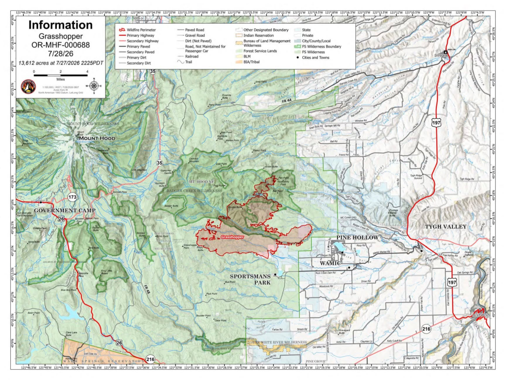
7/27 12:06 pm
Wasco County wildfire update for the 8 mile Road Fire
Update on the 8-Mile Fire (Eightmile Road area, roughly 5 miles west of Dufur):
According to an official Oregon Department of Forestry update from The Dalles Unit Forester Chase D. Duncan, the fire started on July 24, 2026. It received heavy initial attack from ODF, mutual-aid partners, aircraft, contract resources, and local landowners. Forward progression was stopped that same night at 532 acres.
Crews have since been strengthening containment lines and mopping up hotspots. As of July 26, the fire stood at 35% containment, with further increases expected as mop-up continues deeper from the edge. This fire remains relatively small and is showing steady progress under active management.
Several wildfires continue to burn in and near Wasco County, including the Grasshopper Fire (Mount Hood National Forest area near Wamic/Pine Hollow), the Little Buck Fire (part of the Hay Creek Complex near Shaniko/Antelope/Clarno), and the 10 Mile Fire area near the Jefferson County border. Sizes and activity have changed with weather, and fire behavior can shift quickly.
UPDATE 10 Mile Wildfire & 586 Fire (Near Trout Creek / Jefferson & South Wasco County border)
– 10 Mile Fire Size: 4,834 acres (Cause: Unknown)
– 586 Fire Size: 191 acres (Cause: Lightning, adjacent to 10 Mile fire)
– Responding Units: BLM, ODF, Ashwood Antelope RFPA
– Evacuation Levels:
– Level 3 lowered to Level 2 Get Set: From the Wasco/Jefferson County border on Hwy 97 to the Antelope Hwy/Hwy 97 intersection, to Milepost 3 on Hwy 293, and to the Jefferson County line.
– Level 2 lowered to Level 1 Get Ready: From Highway 97 on the Jefferson County line to the Highway 97/197 intersection, south of South Junction Road to the Deschutes River, and from the Hwy 97/Antelope Hwy intersection to milepost 68 on Hwy 97.
– Level 1 lifed: From north of South Junction Road to the Deschutes River, to Hwy 97, and to Milepost 63 on Hwy 197.
– Road open: South Junction Road
– River Closures: The Prineville District Bureau of Land Management has implemented a closure order for all BLM lands, launches, access points, and backcountry campsites from Warm Springs launch at Hwy 26 to the Locked Gate on the Deschutes River Access Road.
Grasshopper Fire (Mount Hood National Forest near Grasshopper Point) Evacuation Zones
– Size: 10,742+ acres
– Cause: Unknown
– Responding Units: Interagency Type 3 team (Wildland Fire Service and US Forest Service), Oregon Department of Forestry, Oregon State Fire Marshal
– Evacuation Levels:
– Level 3 (Go Now) Mount Hood National Forest – Grasshopper Advisory Zone
– Level 3 (Go Now): Sportsman Park, Pine Hollow, and Wamic.
– Level 2 (Be Set): Smock Road, White River Crossing, Badger Creek, Shadybrook Rd, and Tygh Valley.
– Level 1 (Get Ready): Forest Rd 27 to Friend Rd; Elliot Rd to Friend Rd to Hwy 197.
– Closures: A closure order is in effect for Mount Hood National Forest. Details are available at: https://www.fs.usda.gov/r06/mthood/alerts/closure-place-grasshopper-fire
– Shelter Location: Maupin High School, 699 4th St, Maupin, OR 97037
– Large Animal Shelter – Sherman County Fairgrounds, 66147 Lone Rock Rd, Moro, OR 97039
Little Buck Fire (Haycreek Complex)- Evacuations Remain the Same
– Size: 33,4723+ acres
– Cause: Unknown
– Evacuation Levels (Updated by Wasco County Sheriff’s Office):
– Level 3 (Go Now): Shaniko, Hwy 97 from Shaniko to the Sherman County Border, Antelope, Bennett Rd, Young Life, and Clarno.
– Level 2 (Be Set): Upper Tubs Rd to Cold Camp Rd
– Shelter Location: St. Patrick Catholic Church, 341 SW J St, Madras, OR 97741
Deep Canyon Fire
Size: 8089 acres
– Level 1 Has been lifted
Why Level 3 (“Go Now”) orders can be in place even when a fire appears miles away: High winds (including periods of Red Flag conditions) can cause rapid spread, spotting, and sudden changes in direction. Officials issue and adjust evacuation levels based on current fire activity, forecasted winds, terrain, fuels, and the need to give people safe time to leave before conditions worsen. These decisions prioritize public safety over proximity alone. Levels remain dynamic and can be raised, lowered, or lifted as containment improves or risks change.
The Wasco County Sheriff’s Office and Emergency Management work to provide the most current information possible. Citizen safety is the clear priority.
For the latest, most accurate details:
- Check the live interactive map at perimetermap.com/wascocounty-or. Enter your address to see if you are in an evacuation zone, view current levels, shelters, and related information. This is the recommended primary source for real-time perimeter and evacuation status.
- Follow official updates from the Wasco County Sheriff’s Office (Facebook and other channels) and Oregon wildfire resources.
Sign up for Citizen Alert notifications: Visit the Wasco County Emergency Management website and use the Citizen Alert signup link (Everbridge system). Registering ensures you receive direct alerts for your location by phone, text, or email about evacuations, road issues, and other emergencies. Traditional landlines may receive some notices, but signing up covers additional devices and locations you designate.
Stay informed through these official channels rather than unofficial reports. If you are in an affected area, follow any Level 3 instructions immediately, prepare go-kits if at Level 1 or 2, and monitor conditions. Resources such as shelters (examples have included Maupin High School and locations in Madras) are listed on the Perimeter map and official updates when activated.
Thank you for checking official sources. Conditions can evolve, so the map and Citizen Alert remain the best ways to stay current and prepared.
7/26 9:49 pm
Please find the latest wildfire activity and evacuation updates for Wasco County below:
Grasshopper Fire (Mount Hood National Forest near Grasshopper Point)
– Size: 15,000+ acres
– Cause: Unknown
– Responding Units: Interagency Type 3 team (Wildland Fire Service and US Forest Service), Oregon Department of Forestry, Oregon State Fire Marshal
– Evacuation Levels:
– Level 3 (Go Now): Sportsman Park, Pine Hollow, and Wamic.
– Level 2 (Be Set): Smock Road, White River Crossing, Badger Creek, Shadybrook Rd, and Tygh Valley.
– Level 1 (Get Ready): Forest Rd 27 to Friend Rd; Elliot Rd to Friend Rd to Hwy 197.
– Closures: A closure order is in effect for Mount Hood National Forest. Details are available at: https://www.fs.usda.gov/r06/mthood/alerts/closure-place-grasshopper-fire
– Shelter Location: Maupin High School, 699 4th St, Maupin, OR 97037
– Large Animal Shelter – Sherman County Fairgrounds, 66147 Lone Rock Rd, Moro, OR 97039
Little Buck Fire (Haycreek Complex)
– Size: 28,253+ acres
– Cause: Unknown
– Evacuation Levels (Updated by Wasco County Sheriff’s Office):
– Level 3 (Go Now): Shaniko, Hwy 97 from Shaniko to the Sherman County Border, Antelope, Bennett Rd, Young Life, and Clarno.
– Level 2 (Be Set): Upper Tubs Rd to Cold Camp Rd
– Shelter Location: St. Patrick Catholic Church, 341 SW J St, Madras, OR 97741
10 Mile Wildfire & 586 Fire (Near Trout Creek / Jefferson & South Wasco County border)
– 10 Mile Fire Size: 4,834 acres (Cause: Unknown)
– 586 Fire Size: 191 acres (Cause: Lightning, adjacent to 10 Mile fire)
– Responding Units: BLM, ODF, Ashwood Antelope RFPA
– Evacuation Levels:
– Level 3 (Go Now): From the Wasco/Jefferson County border on Hwy 97 to the Antelope Hwy/Hwy 97 intersection, to Milepost 3 on Hwy 293, and to the Jefferson County line.
– Level 2 (Be Set): From Highway 97 on the Jefferson County line to the Highway 97/197 intersection, south of South Junction Road to the Deschutes River, and from the Hwy 97/Antelope Hwy intersection to milepost 68 on Hwy 97.
– Level 1 (Get Ready): From north of South Junction Road to the Deschutes River, to Hwy 97, and to Milepost 63 on Hwy 197.
– Road closure: South Junction Road is closed except for local traffic. Deschutes River Segment 1 is closed from Warm Springs to Locket Gate.
– River Closures: The Prineville District Bureau of Land Management has implemented a closure order for all BLM lands, launches, access points, and backcountry campsites from Warm Springs launch at Hwy 26 to the Locked Gate on the Deschutes River Access Road.
8 Mile Fire
– Size: 532 acres
– Containment: 35%
– Cause: Unknown
For the most up-to-date evacuation notices and maps, please visit https://perimetermap.com/
7/25 10:49 pm
Grasshopper Fire (Mount Hood Forest near Grasshopper Point)
– Size: 4,000+ acres
– Cause: Unknown
– Responding Units: Interagency Type 3 team (Wildland Fire Service and US Forest Service), Oregon Department of Forestry, Oregon State Fire Marshal
– Evacuations:
– Level 3 (Go Now): Sportsman Park, Pine Hollow, and Wamic.
– Level 2 (Be Set): Smock Road, White River Crossing, Badger Creek, Shadybrook Rd, and Tygh Valley.
– Level 1 (Get Ready): Forest Rd 27 to Friend Rd; Elliot Rd to Friend Rd to Hwy 197.
– Shelter Location: Maupin High School, 699 4th St, Maupin, OR 97037
Little Buck Fire
– Size: 12,382+ acres
– Cause: Unknown
– Evacuations (Updated by Wasco County Sheriff’s Office):
– Level 3 (Go Now): Shaniko, Hwy 97 from Shaniko to the Sherman County Border, Antelope, Bennett Rd, Young Life, and Clarno.
– Level 2 (Be Set): Upper Tubs Rd, and Bennett Rd to the Hwy 218 Milepost.
– Shelter Location: St. Patrick Catholic Church, 341 SW J St, Madras, OR 97741
10 Mile Wildfire & 586 Fire (Near Trout Creek / Jefferson & South Wasco County border)
– 10 Mile Fire Size: 4,774+ acres (Cause: Unknown)
– 586 Fire Size: 191 acres (Cause: Lightning, adjacent to 10 Mile fire)
– Responding Units: BLM, ODF, Ashwood Antelope RFPA
– Road Closures: South Junction Road is closed except for local traffic.
– Evacuations:
– Level 3 (Go Now): From the Wasco/Jefferson County border on Hwy 97 to the Antelope Hwy/Hwy 97 intersection, to Milepost 3 on Hwy 293, and to the Jefferson County line.
– Level 2 (Be Set): From Highway 97 on the Jefferson County line to the Highway 97/197 intersection, south of South Junction Road to the Deschutes River, and from the Hwy 97/Antelope Hwy intersection to milepost 68 on Hwy 97.
– Level 1 (Get Ready): From north of South Junction Road to the Deschutes River, to Hwy 97, and to Milepost 63 on Hwy 197.
For the most up-to-date evacuation notices and maps, please visit https://perimetermap.com/
For Rowe Creek Complex and Hay Creek Complex please see attached documents
7/24 9:20 pm
Please see the following update regarding the ongoing wildfires in Wasco County:
Little Buck Fire
– Size: 4,000+ acres
– Cause: Unknown
– Evacuations (Updated by Wasco County Sheriff’s Office):
– Level 3 (Go Now): Shaniko, and Hwy 97 from Shaniko to the Sherman County Border.
– Level 2 (Be Set): Antelope, and Bennet Rd to the Hwy 218 Milepost.
– Shelter Location: St. Patrick Catholic Church, 341 SW J St., Madras, OR 97741.
8 Mile Rd Fire
– Size: 250+ acres
– Cause: Unknown
– Responding Units: Oregon Department of Forestry, Wamic RFPD, Tygh Valley Fire, Dufur Fire and Ambulance, Petersburg RFPA, Mid Columbia Fire and Rescue, Single Engine Scoopers, and the Sheriff’s Office.
– Evacuations: None at this time.
Grasshopper Fire (Mount Hood Forest near Grasshopper Point)
– Size: 60+ acres
– Cause: Unknown
– Responding Units: Interagency Type 3 team (Wildland Fire Service and US Forest Service), Oregon Department of Forestry.
– Evacuations: Level 1 (Get Ready) for Sportsman Park, Pine Hollow, and Wamic.
10 Mile Wildfire & 586 Fire (Near Trout Creek / Jefferson & South Wasco County border)
– 10 Mile Fire Size: 4,774+ acres (Cause: Unknown)
– 586 Fire Size: 191 acres (Cause: Lightning, adjacent to 10 Mile fire)
– Responding Units: BLM, ODF, Ashwood Antelope RFPA.
– Road Closures: South Junction Road is closed except for local traffic.
– Evacuations:
– Level 3 (Go Now): From the Wasco/Jefferson County border on Hwy 97 to the Antelope Hwy/Hwy 97 intersection, to Milepost 3 on Hwy 293, and to the Jefferson County line.
– Level 2 (Be Set): From Highway 97 on the Jefferson County line to the Highway 97/197 intersection, and south of South Junction Road to the Deschutes River.
– Level 2 (Be Set): From the Hwy 97 – Antelope Hwy intersection to milepost 68 on Hwy 97.
– Level 1 (Get Ready): From north of South Junction Road to the Deschutes River, to Hwy 97, and to Milepost 63 on Hwy 197.
Containment Updates
– Hay Creek Complex & Wilcox Fire
– Rowe Creek Complex (Deep Canyon, Incident 432, and Crosswhite): 100% contained. Crews have secured the western border of the Crosswhite fire on the John Day River.
– Deep Canyon Fire: 8,089 acres (100% contained).
– Incident 432 (Antelope Fire): 2,182 acres.
For the most up-to-date evacuation notices and maps, please visit https://perimetermap.com/wascocounty-or.
7/23 4:30 pm
Following recent storm activity, Wasco County has experienced several spot fires. While most have been immediately contained, local ranchers are actively fighting several lightning-strike fires in the south county.
Additionally, the 10 Mile Wildfire is impacting Jefferson County and South Wasco County and moving toward Highway 97 on the Jefferson-Wasco county border. Consequently, the Wasco County Sheriff’s Office has issued new evacuation levels for the affected areas:
– Level 3 (Go Now): In effect from the Wasco/Jefferson County border on Hwy 97 to the Antelope Hwy/Hwy 97 intersection, to Milepost 3 on Hwy 293, and to the Jefferson County line. There is extreme danger in this area.
– Level 2 (Be Set): In effect for the area extending from Highway 97 on the Jefferson County line to the Highway 97/197 intersection, and south of South Junction Road to the Deschutes River.
– Level 2 (Be Set): In effect from the Hwy 97 – Antelope Hwy intersection to milepost 68 on Hwy 97.
– Level 1 (Get Ready): In effect from north of South Junction Road to the Deschutes River, to Hwy 97, and to Milepost 63 on Hwy 197.
Please note that South Junction Road is closed except for local traffic.
Fire Updates:
– Hay Creek Complex (including the Wilcox Fire): Incident Command has made significant progress securing the perimeter, including the southwestern portion impacting Wasco County.
– Rowe Creek Complex (including Deep Canyon, Incident 432, and Crosswhite): Both wildfires are now 100% contained. Crews have secured the western border of the Crosswhite fire on the John Day River.
Based on this progress, the Wasco County Sheriff’s Office has updated the following evacuations:
– Sherman County Border & Shaniko: The evacuation zone adjacent to Sherman County has been lifted. The Shaniko evacuation level has been lowered to Level 1.
– Lifted: Level 1 evacuation zones for Clarno, Young Life, and the designated portion of Hwy 293.
– Lowered: Evacuation zones for Antelope and the section of Hwy 293 adjacent to the Deep Canyon Fire have been reduced to Level 1.
Please view the most up-to-date evacuation notices and maps at https://perimetermap.com/wascocounty-or.
7/23 1 pm
Here is an update on the wildfire evacuation levels and containment progress for South Wasco County.
Hay Creek Complex (including the Wilcox Fire)
Incident Command has made significant progress securing the perimeter, including the southwestern portion impacting Wasco County.
Rowe Creek Complex (including Deep Canyon, Incident 432 and Crosswhite)
Both wildfires are now 100% contained, and crews have secured the western border in Wheeler County of the Crosswhite fire on the John Day River.
Based on this progress, the Wasco County Sheriff’s Office has updated evacuations as follows:
– Sherman County Border & Shaniko: The evacuation zone adjacent to Sherman County has been lifted. The Shaniko evacuation level has been lowered to Level 1 (Get Ready).
– Lifted: Level 1 evacuation zones for Clarno, Young Life, and the designated portion of Hwy 293.
– Lowered: Evacuation zones for Antelope and the section of Hwy 293 adjacent to the Deep Canyon Fire have been reduced to Level 1.