
6/22 at 5 p.m.
Rowena Fire Daily Update – June 22, 2025
Senator Wyden Visits the Fire as Containment Increases
The Dalles, Ore. – This will be the last update from the Type 3 team between Mid-Columbia Fire & Rescue, Oregon Department of Forestry, and USFS-Columbia River Gorge National Scenic Area Public Information.
Yesterday, Senator Ron Wyden visited local officials and the Type 3 team staff to show support and tour the affected area of Rowena before attending a town hall in Hood River, OR.
Today, firefighters will address the few remaining areas of suppression repair while the majority begin to demobilize and travel home. In the coming week, the Type 3 team will transition out and hand the fire back to local resources. A plan of action has been formed to meet the remaining containment needs for local resources to patrol and monitor. Interior smoke may be present for several weeks if hidden hotspots emerge under heat or wind.
As a reminder, Wasco County will hold two Multi-Agency Resource Center (MARC) events next week to continue to assist individuals and families who have lost their homes or experienced significant damage due to the Rowena Wildfire. Public, private, and nonprofit organizations will join at the Gloria Center, located at 2505 W 7th St in The Dalles, to offer a wide range of services and resources. MARC events will be held on Monday, June 23 from 12 to 3 PM and Wednesday, June 25 from 4 to 6 PM. For questions about the MARC, call 541-506-2724.
All evacuations have been lifted by the Wasco County Sheriff’s Office: www.facebook.com/WascoCountySheriff
The Rowena Fire Facebook page will remain open for now. A local Public Information Officer will remain available for further inquiry about the Rowena Fire via the email above.
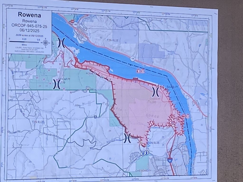
Estimated Size: 3,700 acres
Containment: 96%
Cause: Under Investigation
Estimated Cost: $9,236,811.00
Number of Personnel: 73
ODF Incident Commander: Brian Reel
6/21 at 4 p.m.
Rowena Fire Daily Update – June 21, 2025
Suppression Repair Continues Ahead of Inclement Weather
The Dalles, Ore. – The local Type 3 has made progress on wildfire suppression repair, chipping slash and using heavy equipment to restore areas affected by wildfire suppression efforts. As the restoration continues, crews will begin a glide path to demobilizing.
Today, there is a 70% chance of rain with west winds ranging 10-20 mph, gusts up 25 mph, and a slight chance of lightning. Given the forecast, firefighters are preparing for inclement weather. A soft closure of Highway 30 remains in place, local traffic only advised.
Wasco County will hold two Multi-Agency Resource Center (MARC) events next week to continue to assist individuals and families who have lost their homes or experienced significant damage due to the Rowena Wildfire. Public, private, and nonprofit organizations will join at the Gloria Center, located at 2505 W 7th St in The Dalles, to offer a wide range of services and resources. MARC events will be held on Monday, June 23 from 12 to 3 PM and Wednesday, June 25 from 4 to 6 PM. For questions about the MARC, call 541-506-2724.
All evacuations have been lifted by the Wasco County Sheriff’s Office: www.facebook.com/WascoCountySheriff
The Rowena Fire Facebook page will remain open for now. A local Public Information Officer will remain available for further inquiry about the Rowena Fire via the email above.
Estimated Size: 3,700 acres
Containment: 93%
Cause: Under Investigation
Estimated Cost: $9,135,821.00
Number of Personnel: 80
ODF Incident Commander: Brian Reel
If your mailbox was damaged or destroyed by the Rowena Fire, mail is available for pick up during normal hours at the Post Office in The Dalles (101 W. 2nd St.).
A donation page has been established by United Way of the Columbia Gorge to accept contributions specifically for the Rowena Fire Relief Recovery Fund.
Scan the QR code or visit https://uwcg.ejoinme.org/RowenaFireReliefRecoveryFund to donate today.
For those who prefer to donate by check, contributions can be mailed to:
United Way of the Columbia Gorge
PO Box 2
Hood River, OR 97031
Please include “Rowena Fire Relief Recovery Fund” in the memo line.
6/19 at 1 p.m.
Rowena Fire Daily Update- June 19, 2025
Final Fire Update from the ODF IMT
Rowena, Ore. – Today is the last day the Oregon Department of Forestry’s Incident Management Team will be managing the fire. At 6:00PM. this evening, command will officially transition to a local Type 3 team in unified command between Mid-Columbia Fire & Rescue, ODF’s Central Oregon District – The Dalles Unit, and USFS-Columbia River Gorge Scenic Area. The incoming team will continue working toward the same objectives of completing mop up and containment and working on suppression repair.
Hot and windy conditions are expected again today, with gusty winds likely this afternoon and evening.
With the successful work in building strong fire lines and the increase of containment, the Wasco County Sheriff’s Office has lifted all evacuation levels around the Rowena Fire.
Because of the removal evacuation levels, the Red Cross will close the shelter today.
Temporary Flight Restriction (TFR): A “TFR” is in place at an altitude from the surface up to and including 6500 feet, daily (24 hours) until further notice. Complete information is available at https://tfr.faa.gov/tfr3/?page=detail_5_2600. Flying a drone near or around a wildfire compromises the safety of pilots and interferes with firefighting efforts. This restriction will remain in place until 6PM today.
This will be the final update from the ODF IMT. The ODF Incident Management Team sincerely thanks all cooperating agencies and the public for their support throughout this response. We are especially grateful to the local community. Their support played a vital role in our success.
Waste Connections drivers will be attempting garbage service along Highway 30 on Friday, June 20. They will be inspecting cans/recycling but will not accept any fire debris.
For residents who are not directly on Highway 30, they can take non-fire related garbage and recycling to the transfer station (1317 W 1st St, The Dalles) to dispose of the equivalent amount of the normal paid service. Let the gate staff know they are current customers in good standing and they will waive gate fees.
Residents should not bring fire debris to the transfer station. More information on how to dispose of fire debris will be posted soon.
6/19 at Noon
Rowena Fire Update 1200
All evacuation levels have been lifted. Thank you to all the agencies that have responded to this event. We will continue to post updates for response and recovery efforts.
The Red Cross Shelter at The Dalles Middle School will be closing today at 12 PM today. Mid-Columbia Community Action Council will open the pallet shelter Friday at the Gloria Center at 10 AM.
If you need immediate assistance please call the Disaster Case Management Hotline at 1-833-669-0554.
6/18 at 10: a.m.
Rowena Fire Daily Update- June 18, 2025
Continued progress towards containment
Rowena, Ore. – Firefighters have made significant progress this week, steadily increasing containment on the Rowena Fire each day. Now one week since the fire began, the crews’ tireless efforts are paying off. The southern edge of the fire has up to 150 feet of cold, black line, with other parts of the fire up to 100 feet deep.
Overnight, firefighters continued to patrol for hot spots and mark areas of concern for the incoming day shift. Today, crews will resume detailed grid searches across the fire zone to locate and address any remaining trouble spots. Crews will also continue suppression repair where needed around the fire.
As the situation improves, more crews are being demobilized and are either returning to their home districts or being reassigned to other fires in need of support.
Level 1 and 2 evacuations remain in place. Check the latest perimeter map for up-to-date evacuation information.
The Red Cross shelter remains open at The Dalles Middle School at 1100 East 12th Street. Livestock and horses can be taken to the Wasco County Fairgrounds at 81849 Fairgrounds Road.
I-84 remains open; however, firefighters are continuing to work near the roadway; be aware of crews when driving through the area.
Temporary Flight Restriction (TFR): A “TFR” is in place at an altitude from the surface up to and including 6500 feet, daily (24 hours) until further notice. Complete information is available at https://tfr.faa.gov/tfr3/?page=detail_5_2600. Flying a drone near or around a wildfire compromises the safety of pilots and interferes with firefighting efforts.
If you may need long-term housing assistance related to the Rowena Fire, please join us at the Multi-Agency Resource Center (MARC) today from 4 – 7 PM, or call the Disaster Case Management Hotline at 1-833-669-0554.
The Disaster Case Management hotline can connect you with a dedicated case manager. They’ll help you navigate immediate needs like food, water, and shelter, while also guiding you through long-term recovery and connecting you with vital resources. Call the DCM hotline for personalized support and advocacy.
6/17 at 11:00 a.m.
Rowena Fire Update 1100
https://perimetermap.com/wascocounty-or
LEVEL 2 BE SET Evacuation
– Evacuation from Rowena Ferry Rd, southwest to Highway 30, south to intersection Highway 30 and Dell Rd.
– Rowena Ferry Rd east to Tooley Lake and Simonelli Rd., Basalt Rd., and Adeline Way neighborhood, north to Highway 30.
LEVEL 1 BE SET Evacuation
– **NEW DOWNGRADE** Seven Mile Hill Rd to Mountain View Dr., south to area north of Chenowith Creek Rd and Browns Creek Rd., northeast to The Dalles Country Club
– **NEW DOWNGRADE** Rowena River Rd, north to the Columbia, and to the Simonelli/Basalt/Adeline Way neighborhood.
All previous Level 1 Evacuations have been dropped.
6/16 at 10:00 p.m.
Rowena Fire Evening Update 6/16/25
CONTINUED PROGRESS BUILDS DEPTH OF FIRE LINE
Rowena, Ore. – The Rowena Fire is becoming more secure with each passing day as firefighters from the Oregon Department of Forestry worked strategically around the fire perimeter extinguishing hot embers near the edge of the fire. The containment increased to 37% due to efficient firefighting by our air and ground resources. The southeast side of the fire experienced strong gusty winds this afternoon, forcing firefighters to pause felling operations of hazard trees due to increased safety concerns. They will continue falling efforts tomorrow morning when winds are lighter.
Level 3 evacuations on the fire were lifted today at 12:00 pm by the Wasco County Sheriff’s Office allowing landowners the opportunity to return home and assess the condition of their property. Level 1 and 2 evacuation levels remain in effect in the fire area
The Red Cross shelter remains open at The Dalles Middle School at 1100 East 12th Street. Livestock and horses can be taken to the Wasco County Fairgrounds at 81849 Fairgrounds Road.
I-84 remains open, however firefighters are continuing to work near the roadway; be aware of crews when driving through the area.
Closures: Due to the fires, Mayer State Park is closed to the public. More information is available here: https://stateparks.oregon.gov/index.cfm?do=park.profile…
Temporary Flight Restriction (TFR): A “TFR” is in place at an altitude from the surface up to and including 6500 feet, daily (24 hours) until further notice. Complete information is available at https://tfr.faa.gov/tfr3/?page=detail_5_2600. Flying a drone near or around a wildfire compromises the safety of pilots and interferes with firefighting efforts.
This will be the final evening update unless conditions change.
6/16 at Noon
Rowena Fire Update 1200
https://perimetermap.com/wascocounty-or
**NEW DOWNGRADE** Evacuation from Rowena Ferry Rd in the east, west to Highway 30, south to intersection of Mountain View Rd. and Seven Mile Hill Rd., southeast the area north of Chenowith Creek Rd and Browns Creek Rd., northeast to the area north of Murray’s Addition and Foley Lakes.
– Rowena River Rd, north to the Columbia
– Basalt St, Simonelli Rd., Morris Ln, Adeline Way, and Hwy 30 west to Tooley Lake.
LEVEL 1 BE SET Evacuation
– **NEW DOWNGRADE** The Dalles Country Club
– **NEW DOWNGRADE** Foley Lakes & Murray’s Addition
– **NEW DOWNGRADE** From The Dalles Country Club, east to I-84, south to River Rd., west to W. 7th St., south to Chenoweth Loop Rd., and west to 10th St.
– Highway 30 west to Dell Rd. and State Rd., south to Seven Mile Hill Rd. east to Mountain View Dr.
– Snipes, west to Chenoweth Loop Rd., Chenowith Creek Rd, to Browns Creek Rd.
All previous Level 1 Evacuations have been dropped.
6/16 at 10:00 a.m.
Morning Update
Fire Containment Increases as Firefighters Dig Deeper into the Fire.
Rowena, Ore. – Last night, firefighters continued to strengthen the fire line using sophisticated handheld infrared devices to search for buried heat below the surface. Today, firefighters will mop up identified hot spots and continue to build depth around the fire perimeter utilizing engines and hand crews. Today’s weather will be slightly cooler, but winds will increase with gusts reaching the mid 40 mph range.
With the threat to structures diminishing, the OSFM Green Team is demobilizing this morning ending the unified command with the Oregon Department of Forestry’s IMT2. Oregon Department of Forestry’s work continues as IMT2 took sole command of the fire at 6:00 am this morning. Two OSFM task forces and three overhead personnel will remain for ongoing structural mitigation. We’d like to thank OSFM and the Oregon Fire Service for their immediate response to the Rowena Fire, and the continued partnership with Federal, State, and local agencies. The relationships that are built and maintained keep the unified command model a success when responding to Oregon’s emergency situations.
Level 1, 2 and 3 evacuations remain in effect under the Wasco County Sheriff’s Office’s direction. You can search for specific addresses here: https://perimetermap.com/wascocounty-or
The Red Cross shelter remains open at The Dalles Middle School at 1100 East 12th Street. Livestock and horses can be taken to the Wasco County Fairgrounds at 81849 Fairgrounds Road.
I-84 remains open, however firefighters are continuing to work near the roadway; be aware of crews when driving through the area.
Closures: Due to the fires, Mayer State Park is closed to the public. More information is available here: https://stateparks.oregon.gov/index.cfm?do=park.profile…
Temporary Flight Restriction (TFR): A “TFR” is in place at an altitude from the surface up to and including 6500 feet, daily (24 hours) until further notice. Complete information is available at https://tfr.faa.gov/tfr3/?page=detail_5_2600. Flying a drone near or around a wildfire compromises the safety of pilots and interferes with firefighting efforts.
6/15 at 10:00 p.m.
Rowena Fire Evening Update 6/15/25
Rowena, Ore. – Today, conditions aligned favorably for firefighters to successfully carry out a strategic firing operation in the southwestern area of the fire. Crews burned the remaining “green” fuel located between the fire’s edge and the control lines to reduce the risk of reignition and strengthen containment efforts. At the end of shift today the fire will be completely lined with handline and control line.
Tonight, firefighting crews will continue patrolling fire lines and conducting mop-up operations around the fire area.
Infrared cameras will be used overnight to detect hotspots that may not be visible to the naked eye. These areas will be marked so crews on the day shift can fully extinguish them tomorrow.
In coordination with Mid-Columbia Fire & Rescue and the Wasco County Sheriff’s Office Emergency Management, team members from the Oregon State Fire Marshal (OSFM) have completed a comprehensive assessment of the fire-affected area.
The assessment resulted in identifying a total of 56 residential structures and 91 additional structures—including sheds, barns, and shops— being confirmed lost in this devastating incident.
Today, OSFM resources have begun a gradual demobilization as containment and mitigation work continues around affected residences. Unified Command with the Oregon Department of Forestry’s (ODF) Incident Management Team will cease at 6:00 am tomorrow leaving the ODF fire team in sole control of the incident.
Level 1, 2 and 3 evacuations remain in effect under the Wasco County Sheriff’s Office’s direction. You can search for specific addresses here: https://perimetermap.com/wascocounty-or
The Red Cross shelter remains open at The Dalles Middle School at 1100 East 12th Street. Livestock and horses can be taken to the Wasco County Fairgrounds at 81849 Fairgrounds Road.
I-84 remains open, however firefighters are continuing to work near the roadway; be aware of crews when driving through the area.
Closures: Due to the fires, Mayer State Park is closed to the public. More information is available here: https://stateparks.oregon.gov/index.cfm?do=park.profile…
Temporary Flight Restriction (TFR): A “TFR” is in place at an altitude from the surface up to and including 6500 feet, daily (24 hours) until further notice. Complete information is available at https://tfr.faa.gov/tfr3/?page=detail_5_2600. Flying a drone near or around a wildfire compromises the safety of pilots and interferes with firefighting efforts.
6/15 at 1:00 p.m.
Firefighters are performing a back burn in Seven Mile Hill area at 1 PM. You may see an increase in smoke or fire activity.
6/15 at Noon
June 15, 2025 – In coordination with Mid-Columbia Fire & Rescue and the Wasco County Sheriff’s Office Emergency Management, team members from the Oregon State Fire Marshal (OSFM) have completed a comprehensive assessment of the fire-affected area. This assessment has yielded accurate data regarding structural losses resulting from the recent wildfire.
As of this official count, a total of 56 residential structures and 91 additional structures—including sheds, barns, and shops—have been confirmed lost in this devastating incident. It’s also important to note, that as of the release of this information we have no confirmed lost lives. While the damage is significant, it is important to recognize the extraordinary efforts of the initial firefighting teams and ongoing response personnel. Thanks to their dedication and swift action, many homes were preserved.
Today, OSFM resources have begun a gradual demobilization as containment and mitigation work continues around affected residences. Several task forces remain in the area and are actively engaged in patrolling the perimeter, monitoring for hotspots and other potential hazards to ensure continued public safety.541-993-8173
6/15 at 10:00 a.m.
Rowena Fire Update 1000
https://perimetermap.com/wascocounty-or
LEVEL 3 GO NOW! Evacuation from Rowena Ferry Rd in the east, west to Highway 30, south to intersection of Mountain View Rd. and Seven Mile Hill Rd., southeast the area north of Chenowith Creek Rd and Browns Creek Rd., northeast to the area north of Murray’s Addition and Foley Lakes.
LEVEL 2 BE SET Evacuation
– **NEW DOWNGRADE** Rowena River Rd, north to the Columbia River
– Basalt St, Simonelli Rd., Morris Ln, Adeline Way, and Hwy 30 west to Tooley Lake.
– The Dalles Country Club
– Foley Lakes & Murray’s Addition
– From The Dalles Country Club, east to I-84, south to River Rd., west to W. 7th St., south to Chenoweth Loop Rd., and west to 10th St.
– Highway 30 west to Dell Rd. and State Rd., south to Seven Mile Hill Rd. east to Mountain View Dr.
– Snipes, west to Chenoweth Loop Rd., Chenowith Creek Rd, to Browns Creek Rd.
LEVEL 1 BE READY Evacuation
– Port area of The Dalles
– I-84 MP 75, west to MP 73, south to intersection of State Rd and Marsh Cut Off Rd., east to Dell Rd.
– Intersection of Dell Rd and State Rd., west to Morgensen Rd., south to Dry Creek Rd., east to State Rd.
– Dry Creek Rd., west to Carroll Rd and Catron Rd., south to Osborn Cutoff Rd. northeast to Dry Creek Rd.
– Intersection of Dry Creek Rd and Osborn Cutoff Rd, south to Vensel Rd., southeast to Chenowith Creek Rd. and northeast to Seven Mile Hil Rd.
– From the intersection of Seven Mile Hill Rd, east to Browns Creek Rd, East to Snipes St. to Cherry Heights Rd, south to Browns Creek Rd.
Note that the area of Snipes St., east to Cherry Heights Rd, north to I-84 and south to The City of The Dalles border have had evacuation levels dropped.
Rowena proper will remain at a LEVEL 3 GO NOW! Evacuation due to dangerous conditions and falling trees. We will continue to evaluate the situation.
6/15 at 9:00 a.m.
Rowena Fire Morning Update 6/15/25
Rowena Fire resources focus on bolstering containment line
Rowena, Ore. – Firefighters on the Rowena Fire made steady progress through the night, continuing mop-up operations across the incident. Sunday’s dayshift will pick up where night crews left off, finding hotspots, or areas that are still holding heat or embers that could flare up again in warm, windy conditions. As firefighters extinguish these areas, the line around the fire’s perimeter grows stronger and containment will naturally increase.
Overnight, firefighters continued prepping two small areas on the fire’s south line that, weather depending, may be tactically burned today to build a stronger containment feature. These operations would be extremely beneficial to overall progress on the incident, as these portions of the line still hold unburned fuel and an increased risk for fire to reignite. If weather conditions allow, these operations will begin in the morning and may put off more smoke than has been recently visible. Firefighters will be prepared with resources in place to safely and sufficiently conduct the operation.
Additionally, hazard tree removal remains another focus across the fire, especially in areas along I-84 and Highway 30, and around homes. As firefighters remove these trees, it becomes a safer environment for them to work in, as well as a safer place for residents to return to. Structural resources are continuing to slowly demobilize as progress continues and is completed around houses.
The Wasco County Sheriff’s Office still has Level 1, 2 and 3 evacuation levels in place. You can search for specific addresses here: https://perimetermap.com/wascocounty-or
The Red Cross shelter remains open at The Dalles Middle School at 1100 East 12th Street. Livestock and horses can be taken to the Wasco County Fairgrounds at 81849 Fairgrounds Road.
Firefighters continue to work along I-84, which is open to traffic. When traveling through the area, please be aware of resources working near the road.
Closures: Due to the fires, Mayer State Park is closed to the public. More information is available here: https://stateparks.oregon.gov/index.cfm?do=park.profile…
Temporary Flight Restriction (TFR): A “TFR” is in place at an altitude from the surface up to and including 6500 feet, daily (24 hours) until further notice. Complete information is available at https://tfr.faa.gov/tfr3/?page=detail_5_2600
Flying a drone near or around a wildfire compromises the safety of pilots and interferes with firefighting efforts.
6/15 at 8:00 a.m.
Volunteers with the Wasco County Sheriff’s Office has begun calling individuals whose homes in Rowena were damaged or destroyed. We’ll be asking to confirm information like your name and property address to help with our records.
We understand that phone scams are common, and we want to assure you that these are legitimate calls from the Sheriff’s Office. If you have any doubts or wish to verify the call, please do not hesitate to contact our non-emergency line directly at 541-296-5454.
Your cooperation is appreciated as we work to support our community. Please help us spread the word to your friends and neighbors in Rowena.
6/14 at 9:00 p.m.
Mop up operations, hazard tree removal become main focus on Rowena Fire, some evacuations downgraded
Rowena, Ore. – Firefighters assigned to the Rowena Fire are continuing to make steady progress across the incident. With Saturday’s dayshift complete, the focus of the fire has largely turned to completing control lines around the fire perimeter, mop-up operations and continued hazard tree removal.
On the southwest portion of the fire, resources were able to connect existing lines, securing the perimeter in those areas and completing that section. Firefighters working in the same area tonight will continue to strengthen this length of fireline in preparation for potential burn operations tomorrow to remove unburned fuel between the fires edge and the fire line. This will ultimately strengthen the line and provide a better control feature.
Across the rest of the incident, mop-up continues, especially around homes and structures along I-84 and Highway 30. In most of these areas, mop-up has been completed 100 feet out from the structures.
Tomorrow, an additional four hand crews are arriving to the incident to assist in mop-up efforts across the fire. Meanwhile, structural resources continue to slowly demobilize, as the threat to homes and communities continues to diminish.
The Wasco County Sheriff’s Office downgraded the area of The Dalles Country Club from a Level 3 to a Level 2 – Be Set Evacuation level, allowing them reopening for business today, June 14, 2025, at 12:00 PM. Additionally, Basalt St, Simonelli Rd., Morris Ln, Adeline Way, and Hwy 30 west to Tooley Lake was downgraded to a Level 2 – Be Set. You can search for specific addresses here: https://perimetermap.com/wascocounty-or
The Red Cross shelter remains open at The Dalles Middle School at 1100 East 12th Street. Livestock and horses can be taken to the Wasco County Fairgrounds at 81849 Fairgrounds Road.
Firefighters continue to work along I-84, which is open to traffic. When traveling through the area, please be aware of resources working near the road.
Closures: Due to the fires, Mayer State Park is closed to the public. More information is available here: https://stateparks.oregon.gov/index.cfm?do=park.profile…
Temporary Flight Restriction (TFR): A “TFR” is in place at an altitude from the surface up to and including 6500 feet, daily (24 hours) until further notice. Complete information is available at https://tfr.faa.gov/tfr3/?page=detail_5_2600
Flying a drone near or around a wildfire compromises the safety of pilots and interferes with firefighting efforts.
6/14 at 6:00 p.m.
Rowena Fire Update 1800
https://perimetermap.com/wascocounty-or
LEVEL 3 GO NOW! Evacuation from Rowena River Rd in the east, west to Highway 30, south to intersection of Mountain View Rd. and Seven Mile Hill Rd., southeast the area north of Chenowith Creek Rd and Browns Creek Rd., northeast to the area north of Murray’s Addition and Foley Lakes.
LEVEL 2 BE SET Evacuation
– **NEW DOWNGRADE** Basalt St, Simonelli Rd., Morris Ln, Adeline Way, and Hwy 30 west to Tooley Lake.
– The Dalles Country Club
– Foley Lakes & Murray’s Addition
– From The Dalles Country Club, east to I-84, south to River Rd., west to W. 7th St., south to Chenoweth Loop Rd., and west to 10th St.
– Highway 30 west to Dell Rd. and State Rd., south to Seven Mile Hill Rd. east to Mountain View Dr.
– Snipes, west to Chenoweth Loop Rd., Chenowith Creek Rd, to Browns Creek Rd.
LEVEL 1 BE READY Evacuation
– Port area of The Dalles
– I-84 MP 75, west to MP 73, south to intersection of State Rd and Marsh Cut Off Rd., east to Dell Rd.
– Intersection of Dell Rd and State Rd., west to Morgensen Rd., south to Dry Creek Rd., east to State Rd.
– Dry Creek Rd., west to Carroll Rd and Catron Rd., south to Osborn Cutoff Rd. northeast to Dry Creek Rd.
– Intersection of Dry Creek Rd and Osborn Cutoff Rd, south to Vensel Rd., southeast to Chenowith Creek Rd. and northeast to Seven Mile Hil Rd.
– Snipes St, east to River Rd, south to Bargeway Rd., west to I-84
– From the intersection of Seven Mile Hill Rd, east to Browns Creek Rd, East to Snipes St. to Cherry Heights Rd, south to Browns Creek Rd.
Rowena proper will be evaluated on a continuous basis and as areas are determined safe for re-entry, they be downgraded.
EMERGENCY NOTICE:
North Central Public Health District has identified underground septic hazards in wildfire-affected areas.
If you see yellow and black caution tape at your home, do not enter that area—danger is present. No tape does not guarantee safety of any given area. Some septic systems remain unidentified or unmarked.
Know your septic system location, avoid the area, and mark it clearly from a safe distance to protect others.
Extreme heat can damage septic systems and cause collapse risk.
Be alert for potential underground hazards.
6/14 at 5:00 p.m.
We know that tensions can be high in emergency situations like this. We would like to let everyone know that Wasco County Emergency Management is working with Christine Carter, the State District District Veterinarian, to support all animal needs as they are reported to us.
We are getting information from survey teams in the fire zone, and as they come across these instances, we are responding swiftly and safely.
We have donations of feed, hay, and other supplies and deploy these when notified.
6/14 at 2:00 p.m.
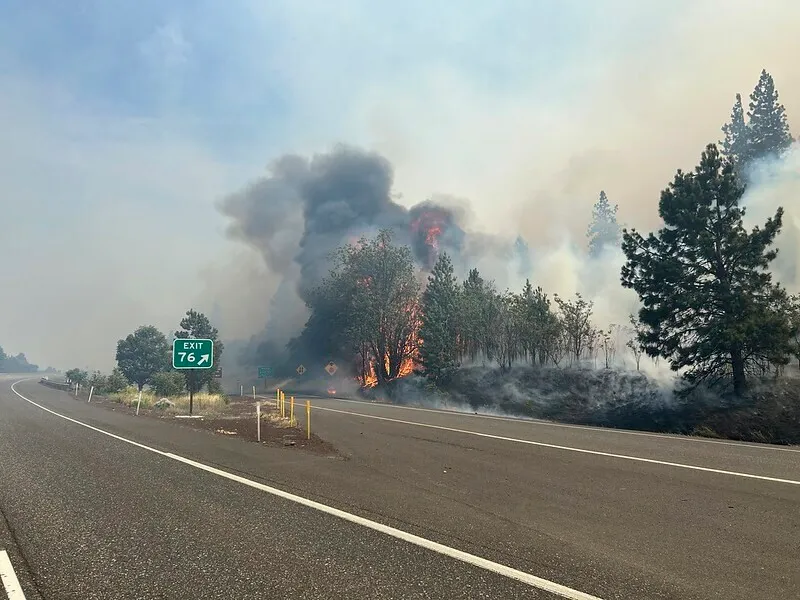
Crews on the Rowena Fire have faced a wide range of conditions over the past few operational periods. In some areas, firefighters were able to work in flatter terrain with good access for engines and heavy equipment. In others, they navigated steep slopes and rugged ground, where winds swirled unpredictably and access was limited to foot travel.
Strong gusts, especially along ridgelines, complicated efforts and increased fire activity in several locations. These photos and videos highlight the diverse and often difficult environments firefighters have been working in.
We’re proud of the hard work and resilience shown by every crew member across the fireline.
6/14 at Noon
Rowena Fire Update 1200
https://perimetermap.com/wascocounty-or
LEVEL 3 GO NOW! Evacuation from Rowena River Rd in the east, west to Highway 30, south to intersection of Mountain View Rd. and Seven Mile Hill Rd., southeast the area north of Chenowith Creek Rd and Browns Creek Rd., northeast to the area north of Murray’s Addition and Foley Lakes.
LEVEL 2 BE SET Evacuation
– **NEW DOWNGRADE** The Dalles Country Club
– **NEW DOWNGRADE** Foley Lakes & Murray’s Addition
– From The Dalles Country Club, east to I-84, south to River Rd., west to W. 7th St., south to Chenoweth Loop Rd., and west to 10th St.
– Highway 30 west to Dell Rd. and State Rd., south to Seven Mile Hill Rd. east to Mountain View Dr.
– Snipes, west to Chenoweth Loop Rd., Chenowith Creek Rd, to Browns Creek Rd.
LEVEL 1 BE READY Evacuation
– Port area of The Dalles
– I-84 MP 75, west to MP 73, south to intersection of State Rd and Marsh Cut Off Rd., east to Dell Rd.
– Intersection of Dell Rd and State Rd., west to Morgensen Rd., south to Dry Creek Rd., east to State Rd.
– Dry Creek Rd., west to Carroll Rd and Catron Rd., south to Osborn Cutoff Rd. northeast to Dry Creek Rd.
– Intersection of Dry Creek Rd and Osborn Cutoff Rd, south to Vensel Rd., southeast to Chenowith Creek Rd. and northeast to Seven Mile Hil Rd.
– Snipes St, east to River Rd, south to Bargeway Rd., west to I-84
– From the intersection of Seven Mile Hill Rd, east to Browns Creek Rd, East to Snipes St. to Cherry Heights Rd, south to Browns Creek Rd.
SHELTERS: A Red Cross Shelter at The Dalles Middle School (1100 E 12th St, The Dalles, OR 97058).
The Wasco County Fairgrounds (81849 Fairgrounds Rd, Tygh Valley, OR 97063) is open for livestock, horses, and people with trailers.
Hwy 30 between Rowena and The Dalles Country Club is still closed. The Riverfront Trail is closed from The Discovery Center to Klindt Dr.
49 homes have been destroyed, but this is not a comprehensive list of damaged or destroyed homes. Property owners will be contacted in the near future and we have established a Multi-Agency Resource Center (MARC) for our community members to assist with the recovery and rebuilding effort. Once we have a location and hours, more information will be provided.
There are no known fatalities at this time.
6/14 at 9:30 a.m.
Crews Hold Ground on Rowena Fire; Resource Levels Adjust
Rowena, Ore. – Incident priorities remain unchanged today as firefighters continue making steady progress on the Rowena Fire.
Despite sustained winds reaching up to 30 mph overnight, crews had a productive shift. Night operations focused on prepping line along the west and southwest portions of the fire, while patrol and mop-up continued in the southern areas. Fire activity flared up in the northern interior but was successfully extinguished and contained.
Today, crews will continue patrolling and mopping up along the perimeter, while line construction resumes in the southwest to clean up remaining edges. Removing hazard trees remains a top priority, especially along Highway 30 and I-84, where steep terrain and swirling winds pose safety concerns.
Structural resources remain engaged as the Oregon State Fire Marshal begins adjusting its response in line with the decreasing threat to homes.
“As the scope and scale of the fire decrease, we’re adjusting our resources to ensure our workforce continues to align with OSFM’s mission of structural protection. We’re incredibly grateful for the dedication of our crews and look forward to seeing them return home safely to rest and prepare for what’s ahead,”
– Kelly Zakrzewski, Chief of Operations, OSFM
Crews will continue mop-up operations and tactical patrols around previously threatened structures. OSFM will maintain a presence until there is full confidence that the threat to structures has been mitigated.
Winds remain a key factor today. While slightly lighter than yesterday, breezy conditions persist with west-northwest winds ranging from 8–20 mph and gusts up to 33 mph on ridges and upper slopes. Highs are expected in the upper 70s.
“Tomorrow will be the least windy day of the week, but we trade that for even warmer temperatures and lower relative humidities,” – Tom Schuldt, Incident Meteorologist
The drop in wind speeds today will improve helicopter support, allowing for more precise water drops on hotspots within the fire perimeter.
Level 1, 2 and 3 evacuations remain in effect under the Wasco County Sheriff’s Office’s direction. You can search for specific addresses here: https://perimetermap.com/wascocounty-or
The Red Cross shelter remains open at The Dalles Middle School at 1100 East 12th Street. Livestock and horses can be taken to the Wasco County Fairgrounds at 81849 Fairgrounds Road.
I-84 remains open, however firefighters are continuing to work near the roadway; be aware of crews when driving through the area.
6/13 at 11:00 p.m.
Rowena Fire containment at 5%
ROWENA , Ore. – Firefighters working on the Rowena Fire day-shift made good progress in strengthening fire lines around the fire perimeter. Good work was done around the town of Rowena and Highway 30. Structure crews continued mop-up efforts around homes and buildings with the goal of creating a 50-foot buffer around structures within the fire perimeter. Firefighters worked on removing hazardous trees to increase safety in the area while work is ongoing. Crews continue survey work to determine the extent of damage and loss to structures within the fire footprint. This survey work is expected to be completed this weekend.
Weather conditions remained dry with winds of 15-25 miles per hour and temperatures in the low 70’s. Winds are expected to decrease later this evening with humidities reaching 70-75 % creating favorable fire suppression conditions. The current size of the fire remains at 3,831 acres. More accurate mapping will be available as firefighters continue to work along the fire line and gather updated data.
Crews are working this evening to hold the fire in its current footprint, limiting growth and protecting homes and natural resources. These efforts will assist to increase fire containment.
A community meeting was held tonight at The Dalles High School to provide a current fire update to the public. Fire managers and local officials shared progress updates and fielded questions from the audience. A recording of the meeting will be later posted on YouTube and Facebook for those who couldn’t attend in person.
Level 1, 2 and 3 evacuations remain in effect under the Wasco County Sheriff’s Office’s direction. You can search for specific addresses here: https://perimetermap.com/wascocounty-or
The Red Cross shelter remains open at The Dalles Middle School at 1100 East 12th Street. Livestock and horses can be taken to the Wasco County Fairgrounds at 81849 Fairgrounds Road.
I-84 remains open, however firefighters are continuing to work near the roadway; be aware of crews when driving through the area.
Closures: Due to the fires, Mayer State Park is closed to the public. More information is available here:
https://stateparks.oregon.gov/index.cfm?do=park.profile…
Temporary Flight Restriction (TFR): A “TFR” is in place at an altitude from the surface up to and including 6500 feet, daily (24 hours) until further notice. Complete information is available at https://tfr.faa.gov/tfr3/?page=detail_5_2600. Flying a drone near or around a wildfire compromises the safety of pilots and interferes with firefighting efforts.
The community meeting from Friday night is now ready to watch on demand on YouTube. https://youtu.be/VdUIT_iJmDg
6/13 at 1:00 p.m.
The Wasco County Sheriff’s Office posted this information to their Facebook page:
Rowena Fire Update 1300
We are saddened to report that we have identified 49 homes that were destroyed due to the fire during damage assessments. This not a comprehensive list of damaged or destroyed homes and expect that number to grow. Property owners will be contacted in the near future and we are working on establishing a Multi-Agency Resource Center (MARC) for our community members to assist with the recovery and rebuilding effort. Once we have established a location and hours, more information will be provided.
There are no known fatalities at this time. Call the hotline at 541-506-2725 if you are looking for a loved one.
6/13 at 12:00 p.m.
The Wasco County Sheriff’s Office posted this information to their Facebook page:
Rowena Fire Update 1200
https://perimetermap.com/wascocounty-or
LEVEL 3 GO NOW! Evacuation from Rowena River Rd in the east, west to Highway 30, south to intersection of Mountain View Rd. and Seven Mile Hill Rd., southeast to intersection of Chenowith Creek Rd and Browns Creek Rd., northeast to Chenowith Creek Rd. and The Dalles city limit, and north to property line of The Dalles Country Club.
LEVEL 2 BE SET Evacuation
– **NEW DOWNGRADE**From The Dalles Country Club, east to I-84, south to River Rd., west to W. 7th St., south to Chenoweth Loop Rd., and west to 10th St.
– Highway 30 west to Dell Rd. and State Rd., south to Seven Mile Hill Rd. east to Mountain View Dr.
– Snipes, west to Chenoweth Loop Rd., Chenowith Creek Rd, to Browns Creek Rd.
LEVEL 1 BE READY Evacuation
– **NEW DOWNGRADE** – For the Port area of The Dalles
– I-84 MP 75, west to MP 73, south to intersection of State Rd and Marsh Cut Off Rd., east to Dell Rd.
– Intersection of Dell Rd and State Rd., west to Morgensen Rd., south to Dry Creek Rd., east to State Rd.
– Dry Creek Rd., west to Carroll Rd and Catron Rd., south to Osborn Cutoff Rd. northeast to Dry Creek Rd.
– Intersection of Dry Creek Rd and Osborn Cutoff Rd, south to Vensel Rd., southeast to Chenowith Creek Rd. and northeast to Seven Mile Hil Rd.
– Snipes St, east to River Rd, south to Bargeway Rd., west to I-84
– From the intersection of Seven Mile Hill Rd, east to Browns Creek Rd, East to Snipes St. to Cherry Heights Rd, south to Browns Creek Rd.
SHELTERS: A Red Cross Shelter at The Dalles Middle School (1100 E 12th St, The Dalles, OR 97058).
The Wasco County Fairgrounds (81849 Fairgrounds Rd, Tygh Valley, OR 97063) is open for livestock, horses, and people with trailers.
Hwy 30 between Rowena and The Dalles Country Club is still closed. The Riverfront Trail is closed from The Discover Center to Klindt Dr.
A roadblock has been set up by the entrance to the Country Club, which can be used as a turnaround area. We are working hard to reopen areas as they become safe for re-entry and are doing so in a phased approach. We appreciate everyone’s patience while we work through this difficult task.
6/13 at 10:00 a.m.
ROWENA, Ore. – Firefighters working on the Rowena Fire overnight, although continuing to be challenged by the wind, were able to push forward on progress around the town of Rowena and along Highway 30. Sustained winds of 20-30 miles per hour were observed across the fire, however little fire growth was seen. An Infrared (IR) flight was ordered and placed the fire around 3,831 acres. More accurate mapping will be available as firefighters continue to work along the fire line and gather data.
Goals for today are centered around holding the fire in its current footprint, limiting growth and protecting homes and natural resources. Aircraft will continue to remain a critical asset on the fire, and more have been ordered. With more resources arriving to the incident, firefighters will be able to deploy more direct tactics, working at the fire’s edge to create a control line and hold the fire. As this work progresses, containment will increase.
Structural resources will continue to work around homes near the fire’s perimeter, mopping up areas that have seen fire. Firefighters will also be removing hazardous trees to increase safety in the area while work is ongoing and ahead of any residents returning. Firefighters are working as quickly and safely as possible with current evacuations in mind, as well as future fire potential across the state.
“It’s very early in fire season for us to be dealing with a large, fast-moving fire like the Rowena Fire, and deploying one of our incident management teams,” Craig Pettinger, ODF Team 2 Deputy IC said. “It doesn’t bode well for what’s ahead of us knowing we already expect an active fire season. We have a lot of fire season ahead of us, and long seasons take a toll on our firefighters and communities across the state.”
Temperatures will be slightly cooler today in the 70s, and relative humidity will be higher, predicted to reach the mid-30s, meaning more moisture will be in the air. These conditions may help to naturally lower the intensity of the fire behavior, however winds will remain steady and create smoky conditions.
A community meeting will be held tonight at 7 p.m. at The Dalles High School auditorium, 220 E 10th St The Dalles, Oregon 97058, to provide a current fire update to the public. A recording of the meeting will be later posted on YouTube and Facebook for those who can’t attend in person.
Level 1, 2 and 3 evacuations remain in effect under the Wasco County Sheriff’s Office’s direction. You can search for specific addresses here: https://perimetermap.com/wascocounty-or
The Red Cross has opened a shelter at The Dalles Middle School at 1100 East 12th Street. Livestock and horses can be taken to the Wasco County Fairgrounds at 81849 Fairgrounds Road.
I-84 remains open, however firefighters are continuing to work near the roadway; be aware of crews when driving through the area.
Closures: Due to the fires, Mayer State Park is closed to the public. More information is available here: https://stateparks.oregon.gov/index.cfm?do=park.profile…
Temporary Flight Restriction (TFR): A “TFR” is in place at an altitude from the surface up to and including 6500 feet, daily (24 hours) until further notice. Complete information is available at https://tfr.faa.gov/tfr3/?page=detail_5_2600. Flying a drone near or around a wildfire compromises the safety of pilots and interferes with firefighting efforts.
###
6/12 5 p.m.
Fire officials held a briefing Thursday afternoon at Mayer Park on the Rowena fire, heavily attended by Portland media. Unfortunately, strong the wind noise made recording difficult. Here’s what we know as a result of the briefing: Though the fire jumped the freeway in several areas, none of the 20 homes lost in the Rowena area were on the north side of the freeway. One of the areas where the flames did cross over was at Crate’s Point. Wasco County Sheriff Lane Magill responded to a reporter’s question about the Discovery Center.
“The building is still standing but had sustained minor damages,” he said. “The other thing I will report, everybody, unless you’re an authorized personnel, stay out of the fire zone. It’s highly dangerous.”
The fire did burn between the Discovery Center and the freeway, charring the wooden sign next to I-84.
Sheriff Magill reported that there were no fatalities or injuries as a result of the fire.
Fire officials said they had good bulldozer lines between the fire and The Dalles, but at that time the containment was zero. The main concern was fire moving up Sevenmile Hill in steep terrain where it was difficult to reach. One large and two single-engine plane were dumping water, and a trio of helicopters did the same.
Some 180 firefighters from a number of agencies and contractors were on the scene, and at the mid-day briefing, officials said they expected 100 more by the end of the day. Winds remained heavy, enough that windsurfers were taking advantage of them.
At the end of the conference, firefighters who went to use the bathroom at Mayer Park spotted two small areas next to the west parking lot that were streaming smoke and summoned a fire truck to deal with them, and they were quickly dispatched.
Officials said that fire season was a month ahead of schedule, and reminded people that last year in Oregon, a record-setting 1.9 million acres burned.
Though the fire is greatly reduced from Wednesday, there was concern that winds would pick up overnight.
Firefighters douse some smoking spots next to the parking lot lot at Mayer State Park Thursday afternoon.
6/12 at 7:55 a.m.
The following is from the Wasco County Facebook page:
Rowena Fire Update 0645
https://perimetermap.com/wascocounty-or
LEVEL 3 GO NOW! Evacuation from Rowena Ferry Rd. east to River Rd. Seven Mile Hill Rd to Mountain View Dr., south to Chenowith Creek Rd and Browns Creek Rd., east to W 7th St.
LEVEL 2 BE SET Evacuation
– **NEW** Highway 30 west to Dell Rd. and State Rd., south to Seven Mile Hill Rd. east to Mountain View Dr.
– For the Port area of The Dalles.
– Snipes, west to Chenoweth Loop Rd., Chenowith Creek Rd, to Browns Creek Rd.
LEVEL 1 BE READY Evacuation
– **NEW** I-84 MP 75, west to MP 73, south to intersection of State Rd and Marsh Cut Off Rd., east to Dell Rd.
– **NEW** Intersection of Dell Rd and State Rd., west to Morgensen Rd., south to Dry Creek Rd., east to State Rd.
– **NEW** Dry Creek Rd., west to Carroll Rd and Catron Rd., south to Osborn Cutoff Rd. northeast to Dry Creek Rd.
– **NEW** Intersection of Dry Creek Rd and Osborn Cutoff Rd, south to Vensel Rd., southeast to Chenowith Creek Rd. and northeast to Seven Mile Hil Rd.
– Snipes St, east to River Rd, south to Bargeway Rd., west to I-84
– From the intersection of Seven Mile Hill Rd, east to Browns Creek Rd, East to Snipes St. to Cherry Heights Rd, south to Browns Creek Rd.
SHELTERS: A Red Cross Shelter has been opened at The Dalles Middle School (1100 E 12th St, The Dalles, OR 97058).
The Wasco County Fairgrounds (81849 Fairgrounds Rd, Tygh Valley, OR 97063) is open for livestock, horses, and people with trailers.
I-84 has reopened, however Hwy 30 is still closed.


6/12 at 4:30 a.m.
Due to the impact of the Rowena Fire, Wasco County reports that currently they have 733 homes under Level 3 GO NOW evacuation, 1195 homes under Level 2 Be Set evacuation, and 157 homes under Level 1 Be Ready evacuation.
Level 3 go now evacuation levels are still set for Seven Mile Hill Rd to Mountain View Dr., south to Chenowith Creek Rd and Browns Creek Rd., east to W 7th St. Also Level 3 go now orders for 5500 block of Highway 30 to Discovery Rd and Rowena Ferry Rd east to From 5500 Hwy 30.
Level 2 Be set evacuation orders for Port area of The Dalles as well as Snipes, west to Chenoweth Loop Rd., Chenowith Creek Rd, to Browns Creek Rd.
Level 1 Be ready evacuation orders for Snipes St, east to River Rd, south to Bargeway Rd., west to I-84 and Intersection of Seven Mile Hill Rd, east to Browns Creek Rd, East to Snipes St. to Cherry Heights Rd, south to Browns Creek Rd.
I-84 is now open between Hood River and The Dalles. U.S. 30 remains closed due to fire.
Just after 4 p.m., Gov. Tina Kotek invoked the Emergency Conflagration Act, allowing the state fire marshal to mobilize resources.
###
Oregon Department of Transportation video
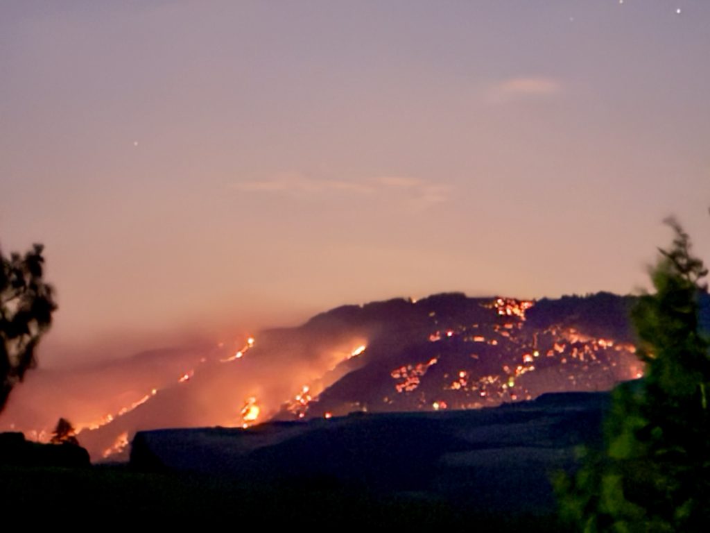
View from Washington side Wednesday night at 10:30. Courtesy of Valerie Fowler, whose home is just east of Catherine Creek.
Oregon Department of Transportation photo from Wednesday
6/11 at 7 p.m.
A fire has been reported at Milepost 78 on I-84 W. Please use caution if you’re in the area.
Rowena Fire 1600 update. https://perimetermap.com/wascocou…/incidents/polygon/62320
LEVEL 3 GO NOW! Evacuation from Rowena Ferry Rd. east to River Rd. Seven Mile Hill Rd to Mountain View Dr., south to Chenowith Creek Rd and Browns Creek Rd., east to W 7th St.
LEVEL 2 BE SET Evacuation Snipes, west to Chenoweth Loop Rd., Chenowith Creek Rd, to Browns Creek Rd.
LEVEL 1 BE READY for Port area of The Dalles.
SHELTERS: The Red Cross has opened a shelter at The Dalles Middle School 1100 East 12th Street, The Dalles, Oregon. If you are affected by the wildfires burning in The Gorge, please come to the shelter. Pets are allowed and volunteers are in place to help.
For updated information, call 1-800-RedCross or download the free Red Cross Emergency App.
The Wasco County Fairgrounds (81849 Fairgrounds Rd, Tygh Valley, OR 97063) is open for livestock and horses.
I-84 and Hwy 30 is closed from Rowena to MP 82. Use alternate route.
Update: Level 1 expands again at 8:50 pm

More detail at 8:50

Level 1 expands with update at 7:01

More details below from 7:01


Map update as of 5:31

Detail as of 5:31 showing level 2 west of Snipes and south of the freeway